Mam Sodhail & Carn Eighe from Glen Affric
Highland Walk
County/Area - Highland - Central Highland
Author - Lou Johnson
Length - 14.4 miles / 23.4 km Ascent - 4300 feet / 1303 metres
Time - 11 hours 30 minutes Grade - hard
Walk Route Description
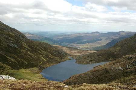
Click image to see photo description.
This demanding walk visits the summits of two Munros, Mam Sodhail and Carn Eighe, which are located on the northern shore of Loch Affric. They are two highest hills north of the Great Glen and the surrounding area is thought by many to offer the finest scenery in the Scottish Highlands. The route initially follows an excellent path which continues into Coire Leachavie. Reaching the head of the corrie, the path zigzags up the steep wall to gain the south ridge of Mam Sodhail. The onward path continues north via a bealach to reach Carn Eighe.
The start is the small pay and display car park at the end of the public road into Glen Affric (grid ref. NH201234). After parking take the path at the western end of the car park to a bridge. Do not cross the bridge and follow the access track leading to Affric Lodge along the north shore of the Loch. As you near the Lodge the path bears right and follows the fence surrounding the grounds. Keep the fence on your left and continue ahead to reach a gate into an area where native Scots Pines are being encouraged to grow. Continue ahead on the clear path to exit the protected area and enter open country.
Continue along the clear track for 800 metres to a junction (grid ref. NH148228). Turn right into Coire Leachavie and follow the clear track into the Corie. The track is clear and easy to follow and gains height steadily towards the head wall. The path zigzags for a short section before following a traverse across the slope to reach the bealach at the foot of Mam Sodhail's south ridge.
The clear path then heads up the ridge to gain the summit of Mam Sodhail (1181 m.). The view is magnificent covering a spectacular array of summits including the next objective Carn Eighe. To continue descend, steeply at first, the north ridge down to a bealach (with Loch Uaine down to the right). Continue ahead up the slope soon bearing northeast to gain the summit of Carn Eighe (1183 m.). The view includes much of that enjoyed from Mam Sodhail but also features the third Munro of the group, Beinn Fhionnlaidh (1005 m.) and Coire Lochan over 500 metres below.
To return, follow the outward route. However, be aware of the steep ground to the left of the path especially on the section back to Mam Sodhail. In poor visibility the junction for the descending path into Coire Leachavie can easily be missed.
Maps 

| Ordnance Survey Explorer 414 | Sheet Map | 1:25k | BUY |
| Anquet OS Explorer 414 | Digital Map | 1:25k | BUY |
| Ordnance Survey Digital Map Subscription | |||
| Latest Ordnance Survey Discounts | |||
Other walks nearby
| Walk 2513 | Five day Knoydart exploration | very hard | 91.4 miles |
| Walk 3083 | Five Sisters Ridge, North Glen Shiel | very hard | 8.0 miles |
| Walk 2468 | Falls of Glomach | moderate | 7.5 miles |
| Walk 3289 | Loch Lundie from Invergarry | easy/mod | 6.5 miles |
| Walk 3275 | Ben Tee & Kilfinnan Falls from Laggan | mod/hard | 7.5 miles |
| Walk 2166 | Laggan Locks Circular | easy | 4.0 miles |
| Walk 2693 | Achnashellach & Easan Dorcha | moderate | 8.8 miles |
| Walk 2824 | Arkaig Hills Circular | moderate | 8.8 miles |
| Walk 1163 | Fraoch Bheinn | moderate | 5.0 miles |
| Walk 1886 | Carn a' Bhealaich Mhoir | easy/mod | 8.0 miles |
Recommended Books & eBooks
Walking in Torridon
 This guidebook contains 52 day walks in Torridon, a remote and much-loved area of the Scottish Highlands. Based around Shieldaig and Slioch, the routes are split into 3 sections: easy walks, long and high level walks and mountain ascents over 2000ft including 9 Munros, and 5 outline suggestions for major ridge walks.
More information
Skye's Cuillin Ridge Traverse
 This 2-volume set provides all the information required to complete the main ridge traverse on Skye's Black Cuillin. Strategy, gear, training, navigation and logistics are covered, and 10 classic scrambles are described. A lightweight second guidebook gives the scrambler detailed maps, topos and route description for the ridge traverse itself.
More information
