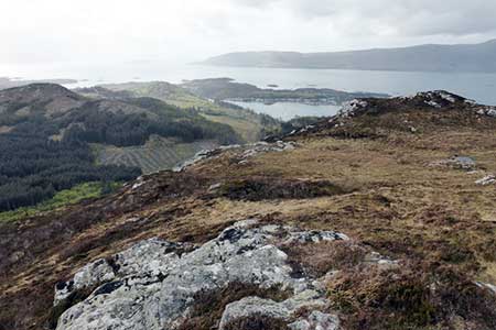
Carn a' Bhealaich Mhoir from Plockton
Highland Walk
County/Area - Highland - Central Highland
Author - Lou Johnson
Length - 8.0 miles / 13 km Ascent - 1400 feet / 424 metres
Time - 5 hours 20 minutes Grade - easy/mod
Walk Route Description
Click image to see photo description.
This varied walk from Plockton Railway station explores the area to the east. The route uses paths, quiet minor roads and tracks passing a reservoir and a loch as well as climbing up to the viewpoint on Carn a' Bhealaich Mhoir from where an extensive view can be enjoyed.
Parking is available at Plockton station (grid ref. NG794329) which served by trains between Inverness and Kyle of Lochalsh. Alternative parking is available on the nearby roads. After parking walk up Station Road to a T-junction and turn right. Almost immediately turn left towards Plockton village. After 200 metres turn right onto a footpath (fingerpost - Duncraig Castle). The path follows the shore with a pleasant view across to the village. The path then passes under the railway and then climbs through trees to a kissing gate at a minor road (grid ref. NG809327).
Turn right to reach a junction. Turn left uphill (signed to Duirinish). Follow the road around a right-hand bend. You soon pass a footpath sign on the left which is where you will return later in the walk. Continue along the rising road through missed woodland to reach the shores of Loch Lundie Reservoir. Continue past the end of the loch to a road junction by a bush shelter (grid ref. NG803315). Turn left, signed Achnahinich, and follow the quiet road to reach the shores of Loch Achaidh na -h-Inich. Pass through the village of Achnadarach to reach the loch shore after 800 metres.
As you make progress you can enjoy good views to the hills that circle the loch. Just after the end of the loch the road forks (grid ref. NG816312). Bear left, pass through a gate to reach a cross-track. Go straight ahead and follow the clear track through woodland. A short optional diversion on the right leads to Sean-chraig hill fort. After about a kilometre from the loch you reach a junction where the track levels off (grid ref. NG819321).
Turn right (signed Carn a' Bhealaich Mhoir viewpoint. The track climbs steeply in places looping across the south face of the carn before reaching easier ground before a final steep section slanting left up to the radio mast. The view is excellent, but it is worth spending time exploring to the north along the edge of the crags to obtain a view across to Plockton.
To return, descend the track used for the ascent back to the junction (grid ref. NG819321). Turn right and follow the descending track which soon sweeps left before continuing down to the road used near the start of the walk. Turn right along the road, right at the first junction and then left through the kissing gate to follow the path back to Plockton station.
Maps 

| Ordnance Survey Explorer 428 | Sheet Map | 1:25k | BUY |
| Anquet OS Explorer 428 | Digital Map | 1:25k | BUY |
| Ordnance Survey Digital Map Subscription | |||
| Latest Ordnance Survey Discounts | |||
Other walks nearby
| Walk 2468 | Falls of Glomach | moderate | 7.5 miles |
| Walk 3083 | Five Sisters Ridge, North Glen Shiel | very hard | 8.0 miles |
| Walk 3753 | Blabheinn via south ridge | mod/hard | 8.0 miles |
| Walk 2002 | Dun Caan, Isle of Raasay | moderate | 10.6 miles |
| Walk 3760 | Glamaig (Sgurr Mhairi & An Coileach) | mod/hard | 4.5 miles |
| Walk 1166 | Loch Coruisk | easy | 4.0 miles |
| Walk 2513 | Five day Knoydart exploration | very hard | 91.4 miles |
| Walk 2589 | Marsco | moderate | 8.7 miles |
| Walk 2693 | Achnashellach & Easan Dorcha | moderate | 8.8 miles |
| Walk 1344 | Beinn Alligin & Sgurr Mor | mod/hard | 6.0 miles |
Recommended Books & eBooks
Walking in Torridon
 This guidebook contains 52 day walks in Torridon, a remote and much-loved area of the Scottish Highlands. Based around Shieldaig and Slioch, the routes are split into 3 sections: easy walks, long and high level walks and mountain ascents over 2000ft including 9 Munros, and 5 outline suggestions for major ridge walks.
More information
Skye's Cuillin Ridge Traverse
 This 2-volume set provides all the information required to complete the main ridge traverse on Skye's Black Cuillin. Strategy, gear, training, navigation and logistics are covered, and 10 classic scrambles are described. A lightweight second guidebook gives the scrambler detailed maps, topos and route description for the ridge traverse itself.
More information
