Moel Hebog from Beddgelert
Snowdonia/Eryri Walk
Nat Park - Snowdonia - Moel Hebog Nantlle Ridge
County/Area - Gwynedd
Author - Lou Johnson
Length - 5.5 miles / 8.9 km Ascent - 2500 feet / 758 metres
Time - 5 hours 20 minutes Grade - moderate
Walk Route Description
Click image to see photo description.
Moel Hebog (782 m.) dominates the view west from the village of Beddgelert and provides the basis for a fairly challenging walk into the mountains that offers great views. The route is easy to follow and includes a couple of sections where the occasional use of hands might be necessary. Like all mountain walks do go well-equipped and make sure you check the weather forecast before departure.
The start is the large car park (grid ref. SH587481) in the centre of Beddgelert. From here make you way to road junction in the centre of the village (grid ref. SH585483). From here follow the A4085 Beddgelert to Caernarfon road for about 500 metres from the village centre and take the bridge over the river on your left (grid ref SH585483). Cross the bridge and follow the track past a couple of farmhouses and through woods to reach a barn (Grid ref. SH581479). Immediately after the barn there is a gate. Go through this and follow the path, which is reasonably well defined and has route markers at low level.
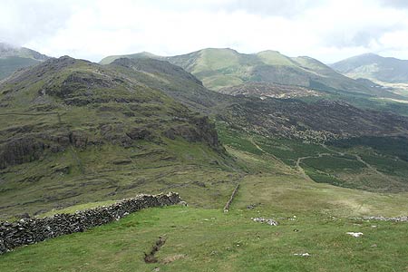
After a short distance from the barn the climbing starts and it is a steep pull all the way to the summit of Moel Hebog. The path continues on an ill-defined ridge and continues to the left of the spectacular crags, Y Diffws, after which there is some light scrambling that will need to use of hands on a couple sections. Looking back you get a superb view of Snowdon together with terrific views to Beddgelert and the Dinas Valley.
The path becomes rocky and is marked by piles of stones. This section leads to a grassy shoulder which in turn leads to another short rocky section and the summit plateau. Like many mountain summits the best view is not obtained from the highest point. Instead the views are all at their finest from the edge of the summit plateau. The views are wide ranging. Snowdon is well known but some lesser known peaks to the north are also worthy of your attention, including namely Mynydd Drws-y-coed and Mynydd Graig Goch at the western end of the Nantlle ridge.
From the summit of Moel Hebog the next leg of the walk heads north following the wall down towards the impressive rock formation at the foot of Moel yr Ogof. Turn right here and follow the path into the forest and down towards the campsite (grid ref. SH577491). Care is needed as navigation is difficult and also some of the tracks lead to dead ends. Continue through the campsite to the road and walk the short distance back to the starting point. From the road you get stunning views of Moel Hebog on your right.
Maps 

| Ordnance Survey Explorer OL17 | Sheet Map | 1:25k | BUY |
| Anquet OS Explorer OL17 | Digital Map | 1:25k | BUY |
| Ordnance Survey Digital Map Subscription | |||
| Latest Ordnance Survey Discounts | |||
Other walks nearby
| Walk 1427 | Craflwyn circular from near Beddgelert | easy/mod | 2.5 miles |
| Walk 3058 | Llyn yr Adar & Llyn Edno from near Bethania | moderate | 9.0 miles |
| Walk 1192 | Yr Aran | mod/hard | 6.5 miles |
| Walk 1103 | Snowdon & Cwm Llan horseshoe | very hard | 13.0 miles |
| Walk 2290 | Snowdon via the Watkin Path & South Ridge from Bethania | mod/hard | 8.0 miles |
| Walk 1136 | Yr Aran (Route 2) | moderate | 5.5 miles |
| Walk 1515 | Tops and Tarns of the Moelwyns | mod/hard | 11.0 miles |
| Walk 2590 | Nantlle Ridge Walk from Rhyd Ddu (Route A) | moderate | 6.0 miles |
| Walk 2797 | Yr Aran and Snowdon from Rhyd-Ddu | mod/hard | 8.5 miles |
| Walk 3509 | Nantlle Ridge from Rhyd Ddu (Route B) | mod/hard | 8.3 miles |
Recommended Books & eBooks
Snowdonia: 30 Low-level and easy walks - North
 Guidebook describing 30 walks in Snowdonia, Wales. Routes are mostly low level and on clear paths and showcase the region's beautiful scenery and rich history and culture. Part of a 2-volume set, this northern volume includes the Snowdon area, the Ogwen and Conwy Valleys, Betws-y-Coed, Beddgelert, Ffestiniog and the coast.
More information
The Wales Coast Path
 A single guidebook to walking the whole Wales Coast Path - 1400km (870 miles) the length of Wales from Chester to Chepstow, including Anglesey, described in 57 stages. The route passes through the Snowdonia and Pembrokeshire National Parks and many AONBs and can be linked with the Offa's Dyke Path for a complete circuit of Wales.
More information
