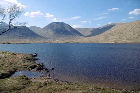
Loch Dochard (near Bridge of Orchy)
Argyll and Bute Walk
County/Area - Argyll and Bute
Author - Lou Johnson
Length - 8.5 miles / 13.8 km Ascent - 500 feet / 152 metres
Time - 4 hours 50 minutes Grade - easy/mod
Walk Route Description
Click image to see photo description.
This walk from near Bridge of Orchy uses tracks and paths to reach Loch Dochard. The route allows you to explore this quiet area with Loch Dochard ringed by mountains especially to the north and west. To reach the start take the road signed to Forest Lodge across the bridge on the west side of the A82 at Bridge of Orchy.
Follow the lane (which is part of the West Highland Way) Past Loch Tulla and the Inveroran Hotel to reach the car park above on the left before Victoria Bridge (grid ref. NN271419). After parking exit the rear of the car park to the left of the information boards and descend to the lane and cross Victoria Bridge. Take the first track on the left just before Forest Lodge. Follow this clear track upstream with the river on your left.
After just under two kilometres, you reach the Clashgour Hut which is used for mountaineering in the area. Continue west across a bridge The main track soon veers right (grid ref. NN254424). At this point bear left off the main track and continue along the riverside track. Continue beside the river for just under two kilometres to reach a footbridge (grid ref. NN238420). Cross the bridge and continue along the north bank of the river to cross a suspension Bridge (grid ref. NN233417).
Once across the river, turn right and continue upstream to reach Loch Dochard in its glorious surroundings. There is a small hut which can provide shelter if the weather worsens. Do allow time to enjoy this mountain setting which is dominated by Munro Meall Nan Eun. You could also consider walking further along the south shore of the loch or having lunch. To return to the start retrace the outward route.
Maps 

| Ordnance Survey Explorer OL50 | Sheet Map | 1:25k | BUY |
| Anquet OS Explorer OL50 | Digital Map | 1:25k | BUY |
| Ordnance Survey Digital Map Subscription | |||
| Latest Ordnance Survey Discounts | |||
Other walks nearby
| Walk 1495 | WHW - Day 5 - Inveroran to Kinlochleven | moderate | 19.0 miles |
| Walk 1019 | Beinn an Dothaidh & Beinn Dorain | moderate | 8.5 miles |
| Walk 3277 | Beinn Dorain | mod/hard | 6.2 miles |
| Walk 3273 | Ben Starav | hard | 8.0 miles |
| Walk 1879 | Ben Starav & Glas Bheinn Mhor` | hard | 10.0 miles |
| Walk 3010 | Stob Dearg (Buachaille Etive Mor) from Altnafeadh | mod/hard | 4.0 miles |
| Walk 3269 | The Munros of Buachaille Etive Mor | mod/hard | 8.2 miles |
| Walk 2819 | Stob na Broige, Buchaille Etive Mor, Glen Coe | mod/hard | 6.1 miles |
| Walk 2808 | Buachaille Etive Beag, Glen Coe | hard | 9.0 miles |
| Walk 2554 | The Lost Valley, Glen Coe | easy/mod | 4.2 miles |
