Beinn Dorain from Bridge of Orchy
Argyll and Bute Walk
County/Area - Argyll and Bute
Author - Lou Johnson
Length - 6.2 miles / 10.1 km Ascent - 2900 feet / 879 metres
Time - 6 hours 0 minutes Grade - mod/hard
Walk Route Description
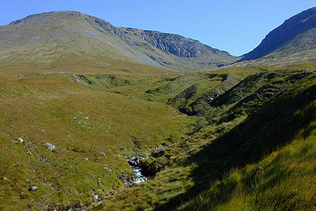
Click image to see photo description.
This walk to the summit of Beinn Dorain from Bridge of Orchy offers a relatively easy hill walk onto a popular Munro. Travellers along the A82 pass this mountain with its distinctive shape. Beinn Dorain lies at the southern end of a ridge with another Munro, Beinn an Dothaidh at the northern end of the ridge. Despite its height of 3530 feet, the route is within the capabilities of most regular hill walkers. This walk only visits Beinn Dorain however Walk 1019 includes both Munros on the ridge.
The start is the car park (grid ref. NN297395) adjacent to the Bridge of Orchy Hotel. After parking cross the A82 with care and head uphill to the railway station (grid ref. NN301395). Continue through the underpass and turn left through a gate to join a clear rising path on the south bank of the Allt Coire an Dothaidh. This leads you into Coire an Dothaidh with its crags rising on either side of the path. A series of zigzags lead steeply through boulders and scree to reach the bealach (grid ref. NN325398). Marked by a cairn there are fine views to Loch Lyon.
From the bealach turn right and follow the obvious route to the summit of Beinn Dorain. The route heads straight up onto a rocky section with a little easy scrambling. The path then levels and veers right to a picturesque lochan (grid ref. NN323394). Head south up scree onto a bumpy ridge. The path splits and it is recommended you ignore the path on the right as staying on the ridge is the safer option especially in poor visibility. This path leads up to a prominent cairn on the north top. After a short descent and re-ascent along a narrow ridge you reach the summit rocks and cairn at 1076m/3530ft (grid ref. NN325378).
The summit is a fine viewpoint, surrounded by mountains. The panorama includes Ben More, Ben Lui, Ben Cruachan, Bidean Nam Bian and Ben Nevis amongst many others. To return to the start retrace your steps north along the ridge to the bealach where you turn left and descend back to Bridge of Orchy.
Maps 

| Ordnance Survey Explorer 377 | Sheet Map | 1:25k | BUY |
| Anquet OS Explorer 377 | Digital Map | 1:25k | BUY |
| Ordnance Survey Digital Map Subscription | |||
| Latest Ordnance Survey Discounts | |||
Other walks nearby
| Walk 1495 | WHW - Day 5 - Inveroran to Kinlochleven | moderate | 19.0 miles |
| Walk 1865 | Loch Dochard (near Bridge of Orchy) | easy/mod | 8.5 miles |
| Walk 2491 | Old Military Road from Victoria Bridge | easy/mod | 6.5 miles |
| Walk 3273 | Ben Starav | hard | 8.0 miles |
| Walk 1879 | Ben Starav & Glas Bheinn Mhor` | hard | 10.0 miles |
| Walk 1406 | Ben More and Stob Binnein | mod/hard | 6.0 miles |
| Walk 3010 | Stob Dearg (Buachaille Etive Mor) from Altnafeadh | mod/hard | 4.0 miles |
| Walk 3269 | The Munros of Buachaille Etive Mor | mod/hard | 8.2 miles |
| Walk 2819 | Stob na Broige, Buchaille Etive Mor, Glen Coe | mod/hard | 6.1 miles |
| Walk 2808 | Buachaille Etive Beag, Glen Coe | hard | 9.0 miles |
