Hole of Horcum & Bridestones from Lockton
North York Moors Walk
Nat Park - North York Moors - North York Moors East
County/Area - North Yorkshire
Author - Lou Johnson
Length - 9.8 miles / 15.9 km Ascent - 1200 feet / 364 metres
Time - 6 hours 10 minutes Grade - moderate
Walk Route Description
Click image to see photo description.
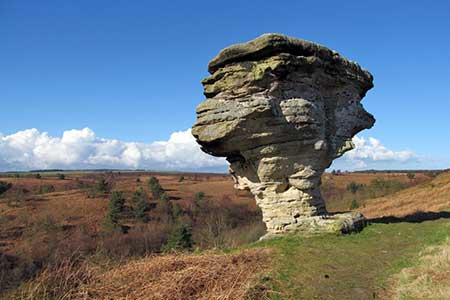
This walk from the village of Lockton explores two notable features of the North York Moors National Park. The undulating route first visits the Hole of Horcum, a vast bowl cut into the moorland before continuing to the Bridestones where large stones have been cut by erosion into interesting shapes.
The start is opposite Lockton Cemetery (grid ref. SE847899). Facing the cemetery, turn right and almost immediately right into a field at the footpath sign. The path crosses the field to join a track which is followed through a gate to reach the A169. passes between trees to reach a gate. Turn left and follow the left-hand grass verge for 40 metres to reach the access road to Warren Farm (grid ref. SE850908) with adjacent footpath sign.
Turn left along the drive and continue to where the drive turns sharp left. At this point pass through a gate, keep the pond on your left and climb past a waymark up to a stile at the top (grid ref. SE819914). Cross the next field keeping to the left-hand edge. In the next field walk half-right to a stile and maintain direction across the next field to reach a farm track. Follow this track as it drops to cross a stream. Bear left up bank and follow wall (on your right) to a stile. Go straight across a large field heading for the far left-hand corner. Cross double stile to join a track (grid ref. SE843926).
Bear left and follow the track which descends into the Hole of Horcum. Pass to the left of the deserted cottage at Low Horcum to follow the well-used path north. Cross a beck and start the climb out of the Hole of Horcum. At the top pass through a gate and turn right onto path below the A169 which is up on your left. From this path you have a grand view over the Hole. At the second bridleway marker, turn left up to the road. Go straight across (with care) onto a tarmac track (Old Wife's Way). After 100 metres, just past the trees, turn left onto a footpath/grassy track.
Continue through gate and after 80 metres turn right onto a grassy bridleway along Satlergate Brow. Pass through another gate and continue for 300 metres to where the track forks (grid ref. SE 859498) to the second blue waymark. Take the right-hand track and continue down the escarpment to reach Malo Cross (grid ref. SE867950). Turn right down the dale with Blakey Ridge plantation on your left. Pass through a gate by trees, head diagonally up the slope, passing Newgate Foot Farm on your left, towards a small gate in the corner (grid ref. SE868935). Cross the farm access track, climb some steps and follow the path which contours along the hillside.
Path then climbs through trees to a stile and a track (grid ref. SE870929). Bear left and continue to where the track forks. Bear left and enter National Trust's Bridestones Moor. After just under a kilometre, you reach a waymark post on your right (grid ref. 877915). Turn right and follow path to join the main path through Bridestones (grid ref. SE874913). Turn right, descend across a stream, and make the short ascent up to Bridestones. Follow the path as it swings south with Dovedale Griff below on your right. Descends steps, cross a small footbridge, and bear right through a gate to Low Staindale. Keep the buildings on your right and join an access driveway.
The driveway climbs across the valley side and then bends right. Before reaching Low Pasture Farm, turn right onto a signed footpath (grid ref. SE866903). Cross several fields to reach a farm a farm track. Bear left. Where the farm track bends to the left, continue ahead through gate and into Thwaite Wood. Emerging from the trees the track bends right and leads to the A169. Cross straight over (with care) and take the minor road opposite. This leads back to the start.
Maps 

| Ordnance Survey Explorer OL27 | Sheet Map | 1:25k | BUY |
| Anquet OS Explorer OL27 | Digital Map | 1:25k | BUY |
| Ordnance Survey Digital Map Subscription | |||
| Latest Ordnance Survey Discounts | |||
Other walks nearby
| Walk 1396 | Hole of Horcum and Saltergate Brow from Lockton | moderate | 10.3 miles |
| Walk 3337 | Dundale Pond from Levisham | easy | 4.8 miles |
| Walk 3585 | Skelton Tower & Hole of Horcum from Levisham | easy/mod | 7.4 miles |
| Walk 1397 | Hole of Horcum from Levisham Station | easy/mod | 8.5 miles |
| Walk 3534 | Dundale Pond & Hole of Horcum from Saltergate | easy/mod | 5.2 miles |
| Walk 1602 | Saltergate, Fylingdales & Allerston High Moor | moderate | 11.5 miles |
| Walk 2665 | Cawthorne Roman Camp Circular | moderate | 12.2 miles |
| Walk 2325 | Troutsdale Circular | moderate | 10.1 miles |
| Walk 1930 | Wheeldale Moor circular | moderate | 11.3 miles |
| Walk 1922 | Goathland & Howl Moors | moderate | 11.2 miles |
Recommended Books & eBooks
Trail and Fell Running in the Yorkshire Dales
 Guidebook to 40 of the best trail and fell runs in the Yorkshire Dales National Park. Ranging from 5 to 24 miles, the graded runs start from bases such as Ribblehead, Dent, Sedbergh, Malham and Grassington and take in the region's diverse delights, from castles and waterfalls to iconic mountains such as Whernside, Ingleborough and Pen Y Ghent.
More information
