Poldhu Cove to Lizard Point
Cornwall AONB Walk
Region - Cornwall AONB
County/Area - Cornwall
Author - Lou Johnson
Length - 9.5 miles / 15.4 km Ascent - 1200 feet / 364 metres
Time - 6 hours 0 minutes Grade - moderate
Walk Route Description
Click image to see photo description.
This superb walk follows the South West Coast Path from pretty Poldhu Cove to Lizard Point, Britain's most southerly point. The route includes many highlights including the harbour at Mullion Cove, Kynance Cove and the varied points of interest around Lizard Point. The walk follows a well waymarked path and offers wonderful, rugged seascapes throughout. The start is Lizard where a number of parking options are available. From here take the bus to Poldhu Cove. Buses are infrequent with suitable morning departures from the village green at Lizard.
The journey to Poldhu Cove takes about 30 minutes where you alight at the back of the beach (grid ref. SW667200). Facing the sea urn left and join the South West Coast Path. Initially the route follows a tarmac driveway but soon bears right off the drive to join a clear path along the clifftops to Poldhu Point. Like many coastal walks expect numerous 'ups' and 'downs' with the first descent taking you down to Polruian Cove followed by a short ascent onto the clifftop.
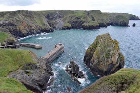
The path is easy to follow, well-signed and is never far from the sea. The next objective is the small harbour at Mullion Cove from here the path returns to the top of the cliffs and soon reaches Predannack Head. The rugged coast continues with many beautiful views so do take your time and enjoy the coastal scenery. Heading south you reach delightful Kynance Cove which features on picture postcards. Just beyond the cove, you reach an outstanding viewpoint (grid ref. SW687133).
The last section of the walk leads to Lizard Point. After relatively quiet walking, hustle and bustle awaits. Continue past the old Lifeboat Station and the Lighthouse before the path veers north-west to reach Housel Bay. Reaching a path junction (grid ref. SW707120) just before the Housel Bay Hotel, turn left and follow the path inland. Reaching Lighthouse Road turn right and walk back into the centre of Lizard.
Maps 

| Ordnance Survey Explorer 103 | Sheet Map | 1:25k | BUY |
| Anquet OS Explorer 103 | Digital Map | 1:25k | BUY |
| Ordnance Survey Digital Map Subscription | |||
| Latest Ordnance Survey Discounts | |||
Other walks nearby
| Walk 2392 | The Lizard Circular | easy/mod | 5.9 miles |
| Walk 2010 | Housel Bay & Bass Point from the Lizard | easy | 3.5 miles |
| Walk 1032 | Kynance Cove, Cadgwith & The Lizard | moderate | 8.0 miles |
| Walk 2001 | Coverack & Lowland Point | easy/mod | 4.2 miles |
| Walk 2007 | Helford Passage & Frenchman's Creek | easy/mod | 7.0 miles |
| Walk 1778 | Maenporth and Helford Passage Circular | easy/mod | 8.0 miles |
| Walk 2009 | Gillan & Nare Point from Porthallow | easy | 4.7 miles |
| Walk 2088 | Rosemullion Head & Mawnan | easy | 4.0 miles |
| Walk 2208 | Marazion - a town stroll | easy | 1.0 miles |
| Walk 3501 | Penzance to Porthcurno via Mousehole and Lamorna | moderate | 11.0 miles |
Recommended Books & eBooks
Walking in Cornwall
 This guidebook includes routes to 40 day walks in Cornwall. From short, easy strolls to longer, wilder routes, there is plenty to appeal to both families and experienced walkers. The walks explore the interior and coasts, including walks through picturesque villages, old tin-mining areas and the Lizard and Land's End Peninsulas.
More information
