Dun Caan, Isle of Raasay
Highland Walk
County/Area - Highland - Isle of Skye
Author - Hebridean Pathways
Length - 10.6 miles / 17.2 km Ascent - 1800 feet / 545 metres
Time - 7 hours 10 minutes Grade - moderate
Maps 

| Ordnance Survey Explorer 411 | Sheet Map | 1:25k | BUY |
| Anquet OS Explorer 411 | Digital Map | 1:25k | BUY |
| Ordnance Survey Landranger 24 | Sheet Map | 1:50k | BUY |
| Anquet OS Landranger 24 | Digital Map | 1:50k | BUY |
Walk Route Description
Click image to visit gallery of 2 images.
The Hebridean Island of Raasay lies quietly to the east of Skye and opposite the mainland area of Applecross. Often over looked due to the proximity of its bigger neighbour, Raasay hides a wealth of great walks and rock climbs together with an abundance of wildlife and history.
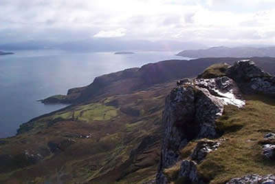
From across the Sound of Raasay the island gives the impression of a long undulating ridge with the only noticeable summit being that of Dun Caan - the highest point at 443m. Although of a modest height in comparison to the Skye and mainland peaks this shapely summit affords a fantastic 360 degree panorama. Views of Kintail, Applecross, Torridon, the Outer Isles and of course the Cuillin provide a great backdrop to the narrow sea channels surrounding the island.
After taking the ferry (grid ref. NG554331) from Sconser (on Skye) the walk is started by heading north along the road to Inverarish and then following directions towards the Youth Hostel. From the hostel continue along the quiet road for 2km to a path junction (Grid ref. 561405). Follow the rocky path southeast for 2km to reach the broad shoulder that is separated from Dun Caan by a great north-south trending cleft containing a narrow loch. The path up the summit cone is obvious and after a short steep section you are rewarded with the fine views. Dun Caan is surrounded by steep cliffs and the scenery to the east drops dramatically 400m to the sea in a series of steep bluffs, hiding the deserted old crofting settlement of Hallaig.
To return to Inverarish the path is retraced down to the loch before heading south alongside a further loch on a narrower and less well defined track across open moorland. This is a favourite hunting ground of the islands golden eagles. The path soon meets the Inverarish burn, winding its way down to the woodland surrounding the village. At the junction with the forest road (Grid ref. 566370) there are a choice of two routes back to the ferry. Heading left is more direct (3km) and follows the line of the old iron mine railway straight to the pier. Heading right takes you back to the village of Inverarish via an old beech woodland from where the coast road is retraced to the pier and ferry (4km).
Note - the total distance of 16km can be reduced to 9km if transport is used to road/path junction at GR 561405.
Other walks nearby
| Walk 3760 | Glamaig (Sgurr Mhairi & An Coileach) | mod/hard | 4.5 miles |
| Walk 2589 | Marsco | moderate | 8.7 miles |
| Walk 3753 | Blabheinn via south ridge | mod/hard | 8.0 miles |
| Walk 3216 | Sgurr a'Ghreadaidh and Sgurr na Banachdich | very hard | 5.5 miles |
| Walk 2197 | The Inaccessible Pinnacle and Sgurr Mhic Choinnich | very hard | 6.0 miles |
| Walk 1164 | The Storr Sanctuary | easy/mod | 3.2 miles |
| Walk 2640 | The Storr & Old Man of Storr | moderate | 5.5 miles |
| Walk 1167 | Glen Brittle & Coire Lagan | moderate | 4.6 miles |
| Walk 1166 | Loch Coruisk | easy | 4.0 miles |
| Walk 1886 | Carn a' Bhealaich Mhoir | easy/mod | 8.0 miles |
Recommended Books & eBooks
Skye's Cuillin Ridge Traverse
 This 2-volume set provides all the information required to complete the main ridge traverse on Skye's Black Cuillin. Strategy, gear, training, navigation and logistics are covered, and 10 classic scrambles are described. A lightweight second guidebook gives the scrambler detailed maps, topos and route description for the ridge traverse itself.
More information
Walking in Torridon
 This guidebook contains 52 day walks in Torridon, a remote and much-loved area of the Scottish Highlands. Based around Shieldaig and Slioch, the routes are split into 3 sections: easy walks, long and high level walks and mountain ascents over 2000ft including 9 Munros, and 5 outline suggestions for major ridge walks.
More information
Messaging & Social Media
Message Walking Britain and follow the latest news.

Mountain Weather
Stay safe on the mountains with detailed weather forecasts - for iOS devices or for Android devices.