Rothiemurchus Forest via Balvattan from Coylumbridge
Cairngorms Walk
Nat Park - Cairngorms - Cairngorm North
County/Area - Highland
Author - Andy Smith
Length - 4.6 miles / 7.5 km Ascent - 300 feet / 91 metres
Time - 2 hours 40 minutes Grade - easy/mod
Walk Route Description
Click image to visit gallery of 3 images.
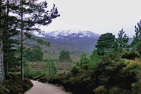
This very short family walk gives very impressive views onto the northern Cairngorm range and the imposing entrance to the Larig Ghru valley. Despite its short distance, this walk gives a real sense of remoteness and adventure making it an ideal all year round walk for the family. It is always within fairly easy range of Coylumbridge village near Aviemore, but make sure you and the family are well prepared for rapid change in weather and temperature.
The route shares its starting point (grid ref. NH915107) with walks 1016, 1721 and 3299 in Coylumbridge close to the hotel. There is ample parking in two large lay-bys close to the campsite and permission can be granted to park at Larig Ghru Cottage (grid ref. NH915104) from the campsite office.
Leave the road via the Larig Ghru footpath passing through a large gate. Continue for a while until the path splits. Take the right signed Glen Einich. Follow the path out the forest. Leaving the forest into the clearing is quite dramatic with superb views straight ahead towards the Cairngorm massif. Clearly the northern corries can be seen along with the immense scale of the Larig Ghru, which may be over 10km in the distance, but appears to be right in front of you!
Simply continue along this track for another 1.5km until a junction is reached, ignore the first, take the second left at grid ref. NH917079 and head east passing Lochan Deo and onto the Cairngorm Club footbridge which makes an ideal half way point to stop for lunch.
Once ready simply retrace your steps for 150m ignoring your previous track on the left, instead continue straight on back into the forest. After a while the track narrows before widening once again as you cross a pretty footbridge deep in this wonderful forest. From here simply walk on until your starting path meets you from the left as you walk back on through the gate and back to reach your car.
Maps 

| Ordnance Survey Explorer OL57 | Sheet Map | 1:25k | BUY |
| Anquet OS Explorer OL57 | Digital Map | 1:25k | BUY |
| Ordnance Survey Digital Map Subscription | |||
| Latest Ordnance Survey Discounts | |||
Other walks nearby
| Walk 1906 | Lochan Mor & Rothiemurchus Forest from Inverdruie | easy/mod | 3.6 miles |
| Walk 1505 | Craigellachie National Nature Reserve | easy/mod | 5.0 miles |
| Walk 1904 | Loch Morlich circular (near Aviemore) | easy | 4.0 miles |
| Walk 2412 | Craiggowrie & Creagan Gorm from Loch Morlich | mod/hard | 7.3 miles |
| Walk 2607 | Lairig Ghru & Chalamain Gap from Glenmore | mod/hard | 11.0 miles |
| Walk 3579 | Meall a'Bhuachaille & Ryvoan Bothy from Glenmore | moderate | 5.5 miles |
| Walk 3218 | Eag a' Chait gap Via Rothiemurchus Lodge from Glenmore | moderate | 8.2 miles |
| Walk 1020 | Glenmore to Linn of Dee via Lairig Ghru & Corrour | hard | 21.0 miles |
| Walk 1605 | Loch an Eilein & Rothiemurchus Forest from Loch Morlich | easy/mod | 10.0 miles |
| Walk 2421 | Braeriach via the Chalamain Gap | hard | 15.0 miles |
Recommended Books & eBooks
Great Mountain Days in Scotland
 Inspirational guidebook to 50 challenging routes for mountaineers, scramblers, hillwalkers and fell runners, many long enough to backpack over 2 days, especially in winter (12 to 25 miles). A mix of classic routes and unsung gems across Scotland from Galloway to the Outer Hebrides in widely differing wild landscapes. With customised OS mapping.
More information
Walking the Munros Vol 2 - Northern Highlands and the Cairngorms
 Guidebook to walking the northern Munros, covering the northern Highlands, the Cairngorms and the Isle of Skye. 70 routes are described, including those up Ben Macdui, Braeriach and Cairn Gorm. Routes range from 7 to 46km, requiring a fair level of fitness. The second of two guidebooks to walking Scotland's Munros: peaks higher than 3000ft.
More information
