Beresford & Wolfescote Dales from Hartington
Peak District Walk
Nat Park - Peak District - Dovedale Manifold Valley
County/Area - Derbyshire & Staffordshire
Author - Lou Johnson
Length - 7.2 miles / 11.7 km Ascent - 550 feet / 167 metres
Time - 4 hours 10 minutes Grade - easy/mod
Walk Route Description
Click image to see photo description.
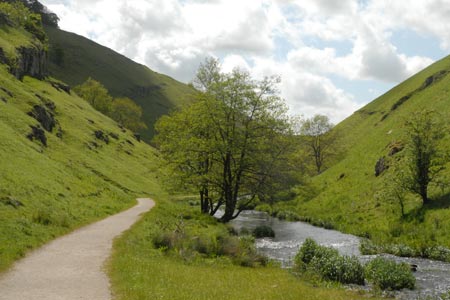
Hartington village with its shops, cafes and pubs makes a perfect start for this Peak District walk in the limestone dales of Staffordshire and Derbyshire. The village, with its green and duck pond, usually has ample parking. On busy days you may have to use the pay and display car park on the B5054 a short way from the centre in the direction of Hulme End. This walk explores Beresford Dale, through which the River Dove flows, before climbing up to the village of Alstonefield from where the route descends back into Dovedale for a return along the river to the start.
To start the walk, follow the B5054 south from the village centre. Close to the public toilets on the left hand side you will locate the signed path into Wolfescote Dale. The path is well used and easy to follow and initially crosses open pastures before entering woodland. You are now in Beresford Dale. The path soon reaches the River Dove and you follow this well-known river south to reach a footbridge (grid ref. SK128588). Cross this to the other side of the river and continue south to a second footbridge at the end of Beresford Lane (grid ref. SK128586).
Turn right down Beresford Lane and after a short distance take the signed footpath on the left. Continue until where the track bends left towards the buildings at Narrowdale (grid ref. SK126576). Here bear right onto a bridleway. At the end of the wall on your left, bear left uphill towards the flank of Narrowdale Hill. Go through the wall and walk left and continue on this footpath/track. Where the track bends left, continue straight ahead across fields and a track to reach a road (grid ref. SK126563).
Turn left along the road for about 600 metres and at grid reference SK129558 bear left onto a track. Keep left walking northeast until you reach a footpath sign on the right hand side (grid ref. SK130558). Turn right here and almost immediately left to follow a well walked path across a number of fields. The path leads into a walled track and continues northeast towards Gypsy Bank and Dovedale.
Continue steeply down into Dovedale. Cross the river using the stepping stones and turn left along the opposite river bank. Continue through Wolfescote Dale to reach the bridge at Beresford Lane. Cross the bridge and return along the path used for the outward part of the walk back into Hartington.
Maps 

| Ordnance Survey Explorer OL24 | Sheet Map | 1:25k | BUY |
| Anquet OS Explorer OL24 | Digital Map | 1:25k | BUY |
| Ordnance Survey Digital Map Subscription | |||
| Latest Ordnance Survey Discounts | |||
Other walks nearby
| Walk 1369 | Tissington Trail - Hartington to Parsley Hey | easy | 4.0 miles |
| Walk 2455 | Lum Edge & Revidge Moor | easy/mod | 6.5 miles |
| Walk 1021 | Milldale & Hall Dale | easy/mod | 5.0 miles |
| Walk 1257 | Wolfscote Dale | easy/mod | 7.5 miles |
| Walk 1709 | Milldale and Wolfscote Dale | easy/mod | 6.5 miles |
| Walk 3597 | Manifold Valley, Thor's Cave, Ecton & Wetton Hills from Alstonefield | moderate | 10.0 miles |
| Walk 3601 | Dove & Manifold Valleys | moderate | 10.0 miles |
| Walk 3709 | Sparklow, Crowdicote & Pilsbury Circular | easy/mod | 9.0 miles |
| Walk 1181 | Wetton Hill & the Manifold Valley | easy/mod | 6.5 miles |
| Walk 1653 | The Manifold Valley from Wetton | easy/mod | 7.8 miles |
Recommended Books & eBooks
Walking in the Peak District - White Peak East
 Guidebook describing 42 half-day and day walks in the limestone landscapes of Derbyshire's White Peak, part of the Peak District National Park. One of two volumes, this book covers the east of the region, with potential bases including Bakewell, Eyam, Castleton, Birchover, Matlock and Wirksworth.
More information
Dark Peak Walks
 Guidebook to 40 walks in the Dark Peak area of the Peak District National Park. 35 circular routes for most abilities, from 8km to 19km, around Edale, Marsden, Fairholmes, Baslow and Castleton, including Kinder Scout and Mam Tor, and 5 longer (25km to 45km) routes highlighting the best of the Gritstone Edges, High Moorland and Deep Valleys.
More information
