Gayle & Aysgill Force from Hawes
Yorkshire Dales Walk
Nat Park - Yorkshire Dales - Wensleydale
County/Area - North Yorkshire
Author - Lou Johnson
Length - 3.5 miles / 5.7 km Ascent - 300 feet / 91 metres
Time - 2 hours 0 minutes Grade - easy
Walk Route Description
Click image to see photo description.
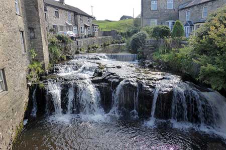
A lovely walk starting from Hawes that explores Gale Beck upstream to Aysgill Force waterfall. The route crosses a typical Yorkshire Dales landscape to the south of Wensleydale. The walk also allows you to explore the village of Gayle where the beck runs through the village and passes over several cascades.
The start is the car park at the Hawes National Park Centre (grid ref. SD876899). (Alternatively parking spaces may be found in the centre of this bustling market town.) After parking follow the access road back to the A684, cross the road and bear right and continue into the town centre. Reaching the church on your left, go through the gate into the churchyard, walk past the church and continue ahead at a path junction to follow the Pennine Way. The path runs close to Gayle Beck which is on your left. Reaching the road in Gayle, turn left and just before a bus shelter on the right follow a path between houses. Cross a road and continue into a field. Walk half left across the field to a lane. Turn right and follow the lane through West End (Gayle). Reaching the end of 30 mph sign, go through a small gate on the left (grid ref. SD868891).
Follow the path with a wall on your right for 150 metres and turn left across two fields to a walled track. Turn left and follow the track as it bends right. Pass a house on the right and walk through a farm (grid ref. SD863886). Just past the farm, the track is enclosed between walls. After a kilometre, the enclosed section ends, and the grassy track crosses a field with a wall on your left. Continue into the next field and pass through a gate on the left (grid ref. SD860877). Just after the gate leave the track and follow a grassy path which runs half left towards Gayle Beck. Just before the beck, turn left through a gate to join the onward path which initially runs beside a wall on your right. After crossing several fields, the path runs close to Gayle Beck and continues downstream past a footbridge to reach Aysgill Falls (grid ref. SD864883). In spate the falls are very dramatic.
After the falls, the path keeps close to the beck. 400 metres beyond the falls, the beck curves right. 200 metres beyond the path veers away from the beck, crosses a field to a stile, and then heads diagonally across the next field to re-join the outward route and Pennine Way (grid ref. SD868890). Instead of retracing your steps along the Pennine Way through West End, cross into the next field and walk half-left across the field keeping just to the right of a wall corner. Continue to a small gate and drop down to the lane. Turn right and continue to a T-junction. Turn right to the "main" road through the village. Turn right a short distance to the road bridge to see the cascades on Gayle Beck, before walking back along the road past the bus stop to turn right along the path used earlier in the walk. Retrace your steps to the church and centre of Hawes.
Maps 

| Ordnance Survey Explorer OL30 | Sheet Map | 1:25k | BUY |
| Anquet OS Explorer OL30 | Digital Map | 1:25k | BUY |
| Ordnance Survey Digital Map Subscription | |||
| Latest Ordnance Survey Discounts | |||
Other walks nearby
| Walk 2363 | Drumaldrace (Wether Fell) from Burtersett | easy/mod | 5.2 miles |
| Walk 3624 | Great Shunner Fell from Hardraw | mod/hard | 9.2 miles |
| Walk 3621 | Great Shunner Fell & Lovely Seat | mod/hard | 11.4 miles |
| Walk 2155 | Mossdale & Cotterdale | easy/mod | 7.9 miles |
| Walk 2265 | Semer Water, Stalling Busk & Marsett | easy | 4.0 miles |
| Walk 3524 | Semer Water and Cam High Road | easy/mod | 5.7 miles |
| Walk 2822 | Aysgarth & Castle Bolton | mod/hard | 14.5 miles |
| Walk 1694 | Nappa Hall & Whitfield Gill Force | easy/mod | 6.0 miles |
| Walk 1053 | Swinner Gill and Muker | mod/hard | 8.5 miles |
| Walk 2409 | The Upper Eden valley without a car | moderate | 12.0 miles |
Recommended Books & eBooks
Walking in the Yorkshire Dales: North and East
 This guidebook contains 43 circular day walks in the north and east Yorkshire Dales. It explores the dales, hills and moors between Kirkby Stephen and Pateley Bridge. Walking ranges from gentle 3 mile strolls to more strenuous day-long rambles across the Howgills, Wensleydale, Swaledale, Nidderdale, Mallerstang and Coverdale.
More information
Pennine Way Map Booklet
 Map of the 270 miles (435km) Pennine Way National Trail, between Edale in the Peak District and Kirk Yetholm in the Scottish Borders. This booklet is included with the Cicerone guidebook to the trail, and shows the full route on Ordnance Survey 1:25,000 maps. This popular long-distance route typically takes three weeks to complete.
More information
