Penbryn & Tresaith
Ceredigion Walk
County/Area - Ceredigion
Author - Lou Johnson
Length - 3.5 miles / 5.7 km Ascent - 800 feet / 242 metres
Time - 2 hours 30 minutes Grade - easy/mod
Walk Route Description
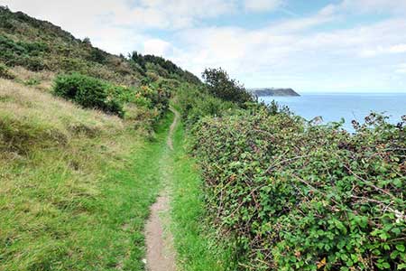
Click image to see photo description.
A short walk from Penbryn exploring the countryside and coast south to Tresaith. The route stays inland for the outward section climbing across a hilly landscape before dropping to down to the Afon Saith. Joining the Ceredigion Coast Path, the walk climbs steeply onto the cliff tops from where excellent views can be enjoyed along the coast. The walk ends with a section of pleasant woodland.
The walk starts from the Penbryn beach car park (grid ref. SN296521). After parking, face the road and turn right. Follow the lane to the first junction and turn right uphill. Follow the lane as it bends left and then take the first track on the left (signed bridleway). Follow the bridleway for 220 metres and turn right up a path between hedges (grid ref. SN298518). At the end of the enclosed section, you enter a field. Walk half-right across the field, pass through trees, enter another field, and keep the large pond on your right. At the end of the pond join a grassy track. This leads through trees into a caravan site. Follow the drive down and the up to a lane (grid ref. SN289515).
Exit the caravan site and turn right along the lane. After 40 metres turn left up a narrow lane and continue down to a T-junction. Turn right and continue downhill to the next junction and turn sharp left. (to shorten the walk. Turn right and after 450 metres turn right onto the Ceredigion Coast Path.) Follow the lane around a right-hand bend and take the first footpath on the right (grid ref. SN283511). Note the path is by a power pole on the right and immediately before a garden wall. Keep the hedge on your left, continue through trees to a path junction. Turn right and continue along a track through trees, pass to the right of the main car park in Tresaith and exit onto a road (grid ref. SN280514).
Turn right downhill and at the next junction go right again. After 30 metres turn left through a gate to Join the Ceredigion Coast Path. The clear path initially heads away from the sea but soon turns left and climbs steeply through woodland to reach a viewpoint from where there is a good view over Tresaith and the coast beyond. After reaching a highpoint about 400 feet above the sea, the path descends gently towards Penbryn. As you near Penbryn, follow the Ceredigion Coast Path signs and pass through woodland to reach the road in Penbryn. Turn right back to the car park used at the start.
Maps 

| Ordnance Survey Explorer 198 | Sheet Map | 1:25k | BUY |
| Anquet OS Explorer 198 | Digital Map | 1:25k | BUY |
| Ordnance Survey Digital Map Subscription | |||
| Latest Ordnance Survey Discounts | |||
Other walks nearby
| Walk 3493 | Llangrannog Circular | easy/mod | 4.5 miles |
| Walk 3492 | Trwyn Crou from Cwmtydu | moderate | 6.1 miles |
| Walk 2656 | New Quay to Cwmtydu using the coastal path | moderate | 8.0 miles |
| Walk 3429 | Byrlip and Ceredigion Coast Path from New Quay | easy/mod | 5.7 miles |
| Walk 3490 | Cemaes Head & Clawddcam from Poppit Sands | moderate | 8.3 miles |
| Walk 3491 | Cwm yr Esgyr & Cemaes Head from Poppit Sands | moderate | 6.1 miles |
| Walk 3494 | Pwllygranant & Cebwr Bay from Moylgrove | mod/hard | 8.5 miles |
| Walk 3468 | Foel Drygarn Hillfort, Preseli Hills | easy | 1.8 miles |
| Walk 3467 | Foel Drygarn Hillfort circular, Preseli Hills | easy/mod | 3.7 miles |
| Walk 2291 | Mynydd Carningli from Newport | easy/mod | 4.5 miles |
Recommended Books & eBooks
The Wales Coast Path
 A single guidebook to walking the whole Wales Coast Path - 1400km (870 miles) the length of Wales from Chester to Chepstow, including Anglesey, described in 57 stages. The route passes through the Snowdonia and Pembrokeshire National Parks and many AONBs and can be linked with the Offa's Dyke Path for a complete circuit of Wales.
More information
