Llangrannog Circular
Ceredigion Walk
County/Area - Ceredigion
Author - Lou Johnson
Length - 4.5 miles / 7.3 km Ascent - 1000 feet / 303 metres
Time - 3 hours 20 minutes Grade - easy/mod
Walk Route Description
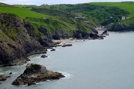
Click image to see photo description.
This Ceredigion walk explores the area around the small seaside village lying to the south of New Quay. The village lies in a steep sided valley and has an excellent beach. This walk initially explores the inland countryside before reaching the coast to follow a section of the Ceredigion Coast Path back to the village.
The start is the free village carpark (grid ref. SN316538) which lies on the south side of the B4334. After parking exit the car park and turn right up the road. The road soon bends sharp left and continues to climb. Just past a house on the right-hand side, take the signed footpath on the left (grid ref. SN319538). The path then passes through woodland to pass Pigeonsford Farm to reach a lane.
Turn left along the lane. Continue over a small stone bridge and uphill to reach a road junction (grid ref. SN327544). Turn right along the B4321 for 200 metres to fork left off the main road. Turn first left up a lane just before a white house on the right. Follow the lane which soon bears right, passes Trecregyn Farm on your left before turning sharp left. Continue ahead along this enclosed lane between hedges. Continue past a house on the left and leave the lane where it bends sharp right (grid ref. SN332511) following a footpath down to the sea on the Ceredigion Coast Path (also the Wales Coast Path).
Turn left and follow the coast path along this rugged section of coastline. The path is clear and generally well-signed. The path climbs steadily soon rising to more than 400 feet above the sea. About 200 metres after reaching the top of the path you reach a track (grid ref. SN317547). Turn right along the track and almost immediately leave the track taking a path on the right. The ancient hillfort of Pen-y-Badell (owned by the National Trust) is located on the top of Pen Dinas Llochtyn, the hill now on your left.
Continue following the clear path soon passi9ng above Traeth-yr-ynys down to your right. The path then curves to the left, passes the rocky outcrop of Carreg Ifan and the follows an undulating route with Llangrannog beach in sight ahead. The path descends to reach the beach and the bustling seafront (grid ref. SN311542). Continue along the road at back of the beach (on your right). Turn left just before the Pentre Arms pub climbing steeply up a narrow lane. Follow the lane upwards as it bends to the right.
Reaching a junction (grid ref. SN311540), turn sharp left and continue to climb. The road levels off before climbing once again. Pass a bungalow on the right and just before reaching a white house on the right turn left onto a signed footpath (fingerpost hidden in the undergrowth). Cross the field half right on a clear path to the B4334. Turn left and the car park used at the start of the walk is a short way along on the left.
Maps 

| Ordnance Survey Explorer 198 | Sheet Map | 1:25k | BUY |
| Anquet OS Explorer 198 | Digital Map | 1:25k | BUY |
| Ordnance Survey Digital Map Subscription | |||
| Latest Ordnance Survey Discounts | |||
Other walks nearby
| Walk 2193 | Penbryn & Llangrannog Circular | easy/mod | 5.4 miles |
| Walk 2250 | Penbryn & Tresaith | easy/mod | 3.5 miles |
| Walk 3492 | Trwyn Crou from Cwmtydu | moderate | 6.1 miles |
| Walk 2656 | New Quay to Cwmtydu using the coastal path | moderate | 8.0 miles |
| Walk 3429 | Byrlip and Ceredigion Coast Path from New Quay | easy/mod | 5.7 miles |
| Walk 3490 | Cemaes Head & Clawddcam from Poppit Sands | moderate | 8.3 miles |
| Walk 3491 | Cwm yr Esgyr & Cemaes Head from Poppit Sands | moderate | 6.1 miles |
| Walk 3494 | Pwllygranant & Cebwr Bay from Moylgrove | mod/hard | 8.5 miles |
| Walk 3468 | Foel Drygarn Hillfort, Preseli Hills | easy | 1.8 miles |
| Walk 3467 | Foel Drygarn Hillfort circular, Preseli Hills | easy/mod | 3.7 miles |
Recommended Books & eBooks
The Wales Coast Path
 A single guidebook to walking the whole Wales Coast Path - 1400km (870 miles) the length of Wales from Chester to Chepstow, including Anglesey, described in 57 stages. The route passes through the Snowdonia and Pembrokeshire National Parks and many AONBs and can be linked with the Offa's Dyke Path for a complete circuit of Wales.
More information
