Trwyn Crou from Cwmtydu
Ceredigion Walk
County/Area - Ceredigion
Author - Lou Johnson
Length - 6.1 miles / 9.9 km Ascent - 1400 feet / 424 metres
Time - 4 hours 30 minutes Grade - moderate
Walk Route Description
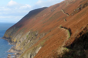
Click image to see photo description.
This often strenuous walk from Cwmtydu uses the Wales Coast Path to complete a circular coastal walk that includes some of the highest cliffs in Wales. The route follows the inland option for the Wales Coast Path to reach the coast southwest of Trwyn Crou. From here a spectacular, and sometimes precipitous, path climbs across the steep hillside above the cliffs often reaching 500 feet above the sea. This path needs care and should be avoided in high winds, ice and snow, and when wet underfoot.
The start is a small parking area beside the river bridge (grid ref. SN357569) about 600 metres south of Cwmtydu. Alternative parking near the beach in Cwmtydu (grid ref. SN356574). After parking, turn right across the bridge and follow the lane uphill. After 800 metres turn left onto a signed footpath (grid ref. SN354562). The path descends across the hillside and soon loops right and then left across a side valley and stream. Shortly after the path forks (grid ref. SN353559). Fork right here, ignoring the descending path on the left. Continue following a generally clear track to reach a lane (grid ref. SN348553).
Turn left along the lane. Continue to a T-junction and turn right signed to Llangrannog. At the next junction fork left and then go straight ahead, ignoring the lane of the left. Follow this lane for 400 metres and turn right onto a descending path by a fingerpost. Drop down, cross small stream and follow the path left. Continue past a building, pass through some trees, and enter a field. Follow the left-hand hedge and continue into the next field. The route then follows a rough track with trees on your right to join a lane (grid ref. SN335543). Bear right along the B4321 and take the signed path on the right after a few metres. Follow the path up through trees to exit at a lane.
Turn right and then after a few metres take the signed footpath on the left. Continue across two fields with the hedge on your left. Continue ahead onto an enclosed lane between hedges. Continue past a house on the left and leave the lane where it bends sharp right (grid ref. SN332511) following a footpath down to the sea.
Reaching the sea, turn right along the Wales Coast Path (also Ceredigion Coast Path). The path initially runs about 80 feet above the sea. However once past Trwyn Crou, the character of the path changes. Ahead can be seen the steep hillside which plunges over 500 feet to the sea. The path climbs steeply up the hillside, soon making a zigzag to gain height on steep ground. An equally steep soon follows before you find that you must regain height again! There is some respite with a short level section before the final ascent leads to the highest point of the walk. The path then descends more gradually with a superb view opening up down to Cwmtydu and along the coast to New Quay and beyond. The path turns right and descends across the hillside to reach the lane used for the initial part of the walk. Turn left and descend back to the start.
Maps 

| Ordnance Survey Explorer 198 | Sheet Map | 1:25k | BUY |
| Anquet OS Explorer 198 | Digital Map | 1:25k | BUY |
| Ordnance Survey Digital Map Subscription | |||
| Latest Ordnance Survey Discounts | |||
Other walks nearby
| Walk 2656 | New Quay to Cwmtydu using the coastal path | moderate | 8.0 miles |
| Walk 3429 | Byrlip and Ceredigion Coast Path from New Quay | easy/mod | 5.7 miles |
| Walk 3493 | Llangrannog Circular | easy/mod | 4.5 miles |
| Walk 2193 | Penbryn & Llangrannog Circular | easy/mod | 5.4 miles |
| Walk 2250 | Penbryn & Tresaith | easy/mod | 3.5 miles |
| Walk 3490 | Cemaes Head & Clawddcam from Poppit Sands | moderate | 8.3 miles |
| Walk 3491 | Cwm yr Esgyr & Cemaes Head from Poppit Sands | moderate | 6.1 miles |
| Walk 3494 | Pwllygranant & Cebwr Bay from Moylgrove | mod/hard | 8.5 miles |
| Walk 1366 | Pentre Bach circular | easy/mod | 9.5 miles |
| Walk 3468 | Foel Drygarn Hillfort, Preseli Hills | easy | 1.8 miles |
Recommended Books & eBooks
The Wales Coast Path
 A single guidebook to walking the whole Wales Coast Path - 1400km (870 miles) the length of Wales from Chester to Chepstow, including Anglesey, described in 57 stages. The route passes through the Snowdonia and Pembrokeshire National Parks and many AONBs and can be linked with the Offa's Dyke Path for a complete circuit of Wales.
More information
