Oxwich Point Circular from Oxwich
Gower Peninsula Walk
Region - Gower Peninsula
County/Area - Swansea
Author - Lou Johnson
Length - 3.5 miles / 5.7 km Ascent - 800 feet / 242 metres
Time - 2 hours 30 minutes Grade - easy/mod
Walk Route Description
Click image to see photo description.
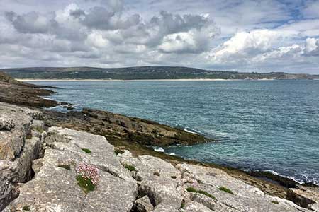
Walk from Oxwich on the Gower Peninsula exploring a fine section of the Wales Coast Path and countryside. The route follows a lane, with a steady climb, through Oxwich Green to Slade. From here the walk leads down to the sea and joins the Wales Coast Path for the reminder of the walk. The undulating coast path runs close to the foreshore to reach Oxwich Point. From here there is an excellent view east across Oxwich Bay. The path then heads up through Oxwich Wood and, after a section along the top of the wood, descends back to the shore for a return to the start.
The walk starts from Oxwich Bay car park (grid ref. SS502865). After parking return to the entrance and turn left along the road to a crossroads. Go straight across (signed Slade) and climb steadily soon passing the entrance to Oxwich Castle on your left. Continue ahead at each junction to walk through Oxwich Green. Reaching the top of climb, the lane descends into the village of Slade. With views to the sea on your left. At the foot of the hill turn left down a narrow lane (Except for access signs) with an adjacent footpath fingerpost. Continue downhill and pass through a metal gate across the lane. Shortly after the gate you reach the Wales Coast Path (grid ref. SS487858).
Fork left and continue down to the foreshore at the back of The Sands. From here follow the path closest to the sea for three kilometres to reach Oxwich Point (grid ref. SS512851) where an information board provides useful information about Oxwich Bay. The path continues close to the shore for 800 metres passing through scattered trees. The path then turns inland climbing up through the trees to the top of the wood. Follow the path its heads right and continue to a path junction (grid ref. SS504859). Turn right here and drop down through trees to re-gain the shore. The path soon joins a tarmac lane which is followed along the beach. To return to the car park either drop down to the beach through a metal gate on your right or turn right up steps shortly after and follow the path back to the car park.
Maps 

| Ordnance Survey Explorer 164 | Sheet Map | 1:25k | BUY |
| Anquet OS Explorer 164 | Digital Map | 1:25k | BUY |
| Ordnance Survey Digital Map Subscription | |||
| Latest Ordnance Survey Discounts | |||
Other walks nearby
| Walk 3761 | Cefn Bryn & Three Cliffs Bay from Penmaen | moderate | 9.0 miles |
| Walk 2358 | Parc le Breos near Parkmill | easy | 3.6 miles |
| Walk 1828 | Three Cliff Bay & Ilston Cwm from Southgate | easy/mod | 9.0 miles |
| Walk 1980 | Pwlldu Head & Bishopston Valley from Southgate | easy | 4.0 miles |
| Walk 1960 | Worms Head from Pilton Green | easy/mod | 7.5 miles |
| Walk 2144 | Port-Eynon from Pilton Green | easy/mod | 6.4 miles |
| Walk 2191 | Cheriton & Weobley Castle from Landimore | easy/mod | 5.2 miles |
| Walk 2424 | Harding's Down & Rhossili Down | moderate | 9.0 miles |
| Walk 3258 | The Beacon from Rossili | easy | 4.0 miles |
| Walk 1967 | Worms Head from Rhossili | easy | 3.3 miles |
