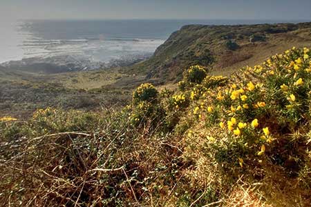
Port-Eynon from Pilton Green
Gower Peninsula Walk
Region - Gower Peninsula
County/Area - Swansea
Author - Lou Johnson
Length - 6.4 miles / 10.4 km Ascent - 600 feet / 182 metres
Time - 3 hours 50 minutes Grade - easy/mod
Walk Route Description
Click image to see photo description.
A circular walk on the Gower Peninsula exploring a dramatic section of coast using the Wales Coast Path. The route starts from Pilton Green a few miles east of Rhossili. During the walk you can enjoy some of the finest coastal scenery in Wales and also interesting flora and fauna. The cliffs in this area are formed from Carboniferous Limestone which extends as a platform into the sea. Ideally choose a time when tides are low to see these limestone platforms at their best.
The walk starts from Pilton Green on the B4247 east of Rhossili where parking is available on the grass verge beside the road leading to Pilton Green Farm (grid ref. SS446871). After parking retrace your steps to the main road and take the footpath opposite. A well-trodden path leads across fields keeping to the right-hand hedge. Just over a kilometre of easy walking takes you to the Wales Coast Path (grid ref. SS439861) at Foxhole Slade.
Turn left along the coast (sea on your right) and continue along the clear path. This part of the route is within the Gower Coast Nature Reserves and you can expect to see a variety of coastal birds as you continue the walk. It is useful to carry the relevant OS 1:25000 map as this will help you identify the many interesting features passed along the coast. The path initially ruins along the cliff tops but descends to pass below Overton Cliff. On this section you have an excellent view across Overton Mere, an extensive limestone reef. An interesting short diversion is to scramble down onto the limestone reef to see Culver Hole.
Return to the Wales Coast Path and continue to Port-Eynon Point. Stay on the waymarked Wales Coast Path and continue through a campsite to reach a roundabout (grid ref. SS468852). Turn left up the A4118 into the village. Keep to the main road and turn left down a side road signed to Overton. After 50 metres turn right onto a track with adjacent fingerpost. Follow the path on the right-hand side of a field. Maintain direction across four more fields to reach a footpath junction (grid ref. SS460861) where you continue ahead ignoring the path to the right. Pass to the left of a stand of trees and continue to reach a grassy track.
Turn left along the track to reach a building (Little Hills). Keep straight ahead here along a track enclosed by hedges. At the end of the enclosed section, pass some derelict buildings at Hills. Maintain direction to pass a trig column keeping a hedge to your left. Continue into the next field and follow the path alongside the hedge. The path bears right and shortly afterwards turns left through a hedge. The onward route follows a hedge on your left to reach a clear track. Turn right and follow the track through the farmyard at Paviland Manor. 250 metres beyond the barns, the path turns left (grid ref. SS447867). Cross the field and reaching the far side, turn right to regain the path used at the start of the walk. Continue north back to the start at Pilton Green.
Maps 

| Ordnance Survey Explorer 164 | Sheet Map | 1:25k | BUY |
| Anquet OS Explorer 164 | Digital Map | 1:25k | BUY |
| Ordnance Survey Digital Map Subscription | |||
| Latest Ordnance Survey Discounts | |||
Other walks nearby
| Walk 2424 | Harding's Down & Rhossili Down | moderate | 9.0 miles |
| Walk 3258 | The Beacon from Rossili | easy | 4.0 miles |
| Walk 1967 | Worms Head from Rhossili | easy | 3.3 miles |
| Walk 2277 | Oxwich Point Circular from Oxwich | easy/mod | 3.5 miles |
| Walk 2287 | Cefn Bryn & Penrice | easy/mod | 7.7 miles |
| Walk 1691 | Whiteford Point & Broughton Bay from Llanmadoc | easy/mod | 8.5 miles |
| Walk 2724 | Whiteford Sands from Llanmadoc | easy | 5.1 miles |
| Walk 2191 | Cheriton & Weobley Castle from Landimore | easy/mod | 5.2 miles |
| Walk 3761 | Cefn Bryn & Three Cliffs Bay from Penmaen | moderate | 9.0 miles |
| Walk 2358 | Parc le Breos near Parkmill | easy | 3.6 miles |
