The Beacon from Rossili
Gower Peninsula Walk
Region - Gower Peninsula
County/Area - Swansea
Author - Lou Johnson
Length - 4.0 miles / 6.5 km Ascent - 700 feet / 212 metres
Time - 2 hours 40 minutes Grade - easy
Maps 

| Ordnance Survey Explorer 164 | Sheet Map | 1:25k | BUY |
| Anquet OS Explorer 164 | Digital Map | 1:25k | BUY |
Walk Route Description
Click image to see photo description.
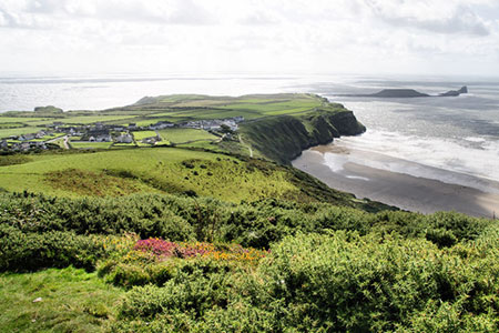
This walk from Rossili on the Gower Peninsula follows an excellent path onto The Beacon on Rossili Down. The return route follows the Wales Coast Path although you could also return along the beach. The walk offers fine views especially to Worm's Head.
The start is the car park on the seafront at Rhossili (grid ref. SS415879). After parking follow the road used to access the car park to pass the church on your left. Just past the church bear left onto a wide path with fingerposts on the right. Continue past the large standing stone on your right, pass through a gate onto Rhossili Down. Take the obvious path climbing steeply through bracken. The gradient soon eases, and you make steady progress uphill with improving views especially behind you to Worm's Head. You soon reach the first objective, the trig column at The Beacon (grid ref. SS420889).
After enjoying the extensive 360-degree panorama continue along the ridge in a northerly direction. Descend to the first dip in the ridge and shortly after fork left soon passing the remains on an old radar station on your right. For a brief section you regain height before the path descends steeply down towards the caravan park at Hillend. Just before reaching a gate (grid ref. SS418908) turn sharp left to follow the Wales Coast Path keeping the boundary fence for the caravan site on your right. Stay on the Wales Coast Path for 2.5 kilometres back to the gate used to access Rhossili Down at the start of the walk. From here retrace your steps along the road past the church to reach the car park.
As an alternative you can return along the beach from Hillend. Pass the shop and turn left down the roadway to Hillend car park. From here a path drops down to the beach. Turn left along the beach and keep the sea on your right. Nearing Rossili, bear left onto a rising path that leads back to the paring area.
Other walks nearby
| Walk 1960 | Worms Head from Pilton Green | easy/mod | 7.5 miles |
| Walk 2144 | Port-Eynon from Pilton Green | easy/mod | 6.4 miles |
| Walk 1691 | Whiteford Point & Broughton Bay from Llanmadoc | easy/mod | 8.5 miles |
| Walk 2724 | Whiteford Sands from Llanmadoc | easy | 5.1 miles |
| Walk 2191 | Cheriton & Weobley Castle from Landimore | easy/mod | 5.2 miles |
| Walk 2277 | Oxwich Point Circular from Oxwich | easy/mod | 3.5 miles |
| Walk 2287 | Cefn Bryn & Penrice | easy/mod | 7.7 miles |
| Walk 3761 | Cefn Bryn & Three Cliffs Bay from Penmaen | moderate | 9.0 miles |
| Walk 2358 | Parc le Breos near Parkmill | easy | 3.6 miles |
| Walk 1828 | Three Cliff Bay & Ilston Cwm from Southgate | easy/mod | 9.0 miles |
Recommended Books & eBooks
No suggestions for this area.Messaging & Social Media
Message Walking Britain and follow the latest news.

Mountain Weather
Stay safe on the mountains with detailed weather forecasts - for iOS devices or for Android devices.