Brown Clee Hill Circular from Brown Clee picnic area
Shropshire Hills Walk
Region - Shropshire Hills
County/Area - Shropshire
Author - Peter Lane
Length - 4.5 miles / 7.3 km Ascent - 920 feet / 279 metres
Time - 3 hours 10 minutes Grade - easy/mod
Walk Route Description
Click image to visit gallery of 9 images.
Brown Clee Hill at 540m is the county top of Shropshire. Like its sister: Titterstone Clee Hill, its summit is marred by a microwave relay station, However, it commands some outstanding views across to its sister and also across to the Long Mynd. This walk has a distinct East/West divide from the summit. To the West is open heather moor and barren wilderness, the East is rural idyll, woods and country estate land.
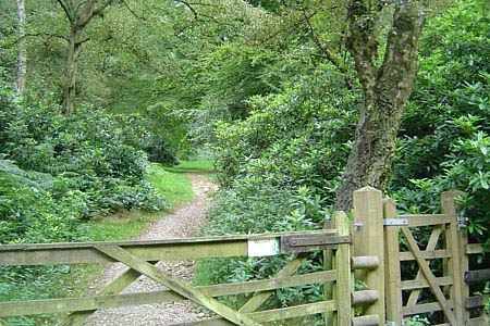
The start point is Brown Clee Picnic Area, a site provided courtesy of the Burwarton Estate at grid reference SO608872. There is ample roadside parking for the few cars likely to be there, but don't expect picnic benches and the like! Climb the hill through the clearing that is the "picnic site" and upon reaching a fence, cross and head up to the park bench further ahead up the hill. Here turn left and follow into woods and meet up with a forestry road. Turn left along this for 100 metres and then follow the footpath waymarked through a wooden gate by some large rhododendrons through idyllic woodland. This pleasant path eventually reaches a gate and the beginning of the Access Land area.
Continue straight on up the hill (not the right of way shown on the OS map, but it's clear on the ground). This path climbs steadily to the rough wilderness summit and an access road to the microwave relay station. Turn left along the tarmac lane, past a cattle grid and around to the newly constructed summit toposcope. This is a good spot to take a short break and admire the views. The descent is on the obvious footpath heading South West from the summit. Follow this until it hits a fence and picks up the Shropshire Way. Head left (South East) along the hillside with some of the best views of the walk ahead and to the right. Titterstone Clee Hill is clearly defined with its steep escarpment and "golf ball" radar domes in the distance. The shapely flank of Clee Liberty lies ahead and to the right are expansive views of rural Shropshire and the Long Mynd in the distance.
Reaching a small wood and a metal gate, leave the Shropshire Way and pass through the gate down a broad track to Big Wood. Whilst this lane will happily take you back, my sense of adventure took me off it after 250 metres where I turned right into an overgrown field on a neglected right of way. Head for the trees and drop down a bracken strewn bank to a gate. Cross the track and follow the small stream to the left in a valley that deepens. This path descends charmingly as it follows the stream and flanks of Big Wood until it emerges at the main access road to the Burwarton Estate.
Head (straight on) along the access road until a broad, well made road comes in sharply from the left. Take a few paces up this road and turn right along a path (permissive). This runs parallel to the Estate road and emerges eventually at the "picnic site".
Maps 

| Ordnance Survey Explorer 217 | Sheet Map | 1:25k | BUY |
| Anquet OS Explorer 217 | Digital Map | 1:25k | BUY |
| Ordnance Survey Digital Map Subscription | |||
| Latest Ordnance Survey Discounts | |||
Other walks nearby
| Walk 2633 | Brown Clee Hill | easy/mod | 6.3 miles |
| Walk 2678 | Wenlock Edge & Broadstone | easy/mod | 6.4 miles |
| Walk 3334 | Titterstone Clee Hill and Catherton Common | easy/mod | 5.5 miles |
| Walk 2654 | Titterstone Clee Hill & Cleeton St. Mary from Cleehill | moderate | 7.5 miles |
| Walk 2022 | Wenlock Edge & Aston Munslow | moderate | 7.8 miles |
| Walk 3447 | Caer Caradoc, Hope Bowdler & Willstone Hills | moderate | 7.0 miles |
| Walk 2807 | The River Severn from Hampton Loade to Bridgnorth | easy/mod | 6.0 miles |
| Walk 3504 | Highley to Bewdley along the River Severn | easy/mod | 7.0 miles |
| Walk 1451 | Dudmaston Estate circular | easy | 4.0 miles |
| Walk 2092 | Highley from the Severn Valley Country Park | easy/mod | 4.5 miles |
Recommended Books & eBooks
Hillwalking in Shropshire
 Guidebook to 32 walking routes in Shropshire in the West Midlands. The routes range from 3 miles (5km) to 12 miles (19km), taking in highlights such as The Wrekin, Wenlock Edge, Long Mynd and Stiperstones, Castle Ring and Bury Ditches. Many routes start near delightful towns and villages including Church Stretton, Ludlow and Bishops Castle.
More information
