Caldbeck & Watersmeet from Hesket Newmarket
Lake District Walk
Nat Park - Lake District - Lake District Northern Fells
County/Area - Cumbria
Author - Lou Johnson
Length - 4.3 miles / 7 km Ascent - 500 feet / 152 metres
Time - 2 hours 40 minutes Grade - easy
Walk Route Description
Click image to see photo description.
Starting from Hesket Newmarket, which lies close to the Northern Fells of the Lake District National Park, this walk explores an area of fields and valleys with a section of woodland. The route passes through the pretty village of Caldbeck, follows a section of the Cumbria Way, and explores Watersmeet where two rivers meet with an "island" at their confluence.
The walk starts from Hesket Newmarket car park (grid ref. NY342386) at the eastern end of the village. After parking return to the road and turn left. Continue uphill soon passing the Post Office on your left. Where the main road bends to the right, continue ahead up The Street. After 600 metres you pass Street Head Farm on your left. 350 metres beyond the farm turn right onto a footpath signed to Matthew Rudding. The path follows a wall on your left to reach a gate. Pass through the gate and head across a field aiming for the farm buildings. Keep to the right of the buildings to locate and exit through a gate in the left-hand corner at the bottom of the field. Continue with the farmhouse on your left and join the farm's access drive (grid ref. NY330391).
Follow the drive to reach a group of buildings at Townhead. Opposite the second building turn right through a kissing gate. You are now following the Cumbria Way. The path follows the left-hand side of a field. Where the hedge bends left continue ahead, pass through a gate, cross a small footbridge and continue ahead to the B5299 in Caldbeck (grid ref. NY323397). Turn right along the main road. At the first junction, bear left (signed to Wigton and Carlisle). Stay on the B5299, ignore the first footpath on the right, cross Cald Beck and turn right into Friar Row (signed as footpath to Hesket Newmarket).
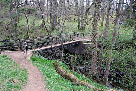
Reaching the end of the lane, pass through gate and continue past a water treatment plant on your left. Pass through a gate and follow a clear path through the woodland of Parson's Park. The path starts to climb. Ignore the path to the right and continue climbing with improving views to the Northern Fells. Nearing the end of Parson's Park, you reach a gate (grid ref. NY339400). 75 metres beyond the gate turn right down to cross a footbridge over Cald Beck. Once over the bridge you are an "island" of woodland surrounded by Cald Beck and the River Caldew. There are many paths, but the best idea is, after crossing the bridge, turn left and then continue with Cald Beck on your left to the confluence of the two rivers at Watersmeet. To continue follow the path beside the River Caldew (also on your left). The path continues by the river to a gate near the footbridge crossed earlier.
Pass through the gate and make a short climb up a bank to a kissing gate. After the gate, cross an open field heading roughly south. After crossing the field, the path re-enters woodland with occasional way markers to help with route finding. The final section is across fields with the path soon reaching the road and village green in Hesket Newmarket. Turn left to return to the car park used at the start of the walk.
Maps 

| Ordnance Survey Explorer OL5 | Sheet Map | 1:25k | BUY |
| Anquet OS Explorer OL5 | Digital Map | 1:25k | BUY |
| Ordnance Survey Digital Map Subscription | |||
| Latest Ordnance Survey Discounts | |||
Other walks nearby
| Walk 2390 | High Pike from Fell Side | moderate | 5.2 miles |
| Walk 2612 | Roughton Gill, Caldbeck Fells | easy | 4.5 miles |
| Walk 1101 | Carrock Fell, High Pike and Knott | moderate | 11.0 miles |
| Walk 1214 | Carrock Fell & High Pike from Mosedale | moderate | 7.0 miles |
| Walk 1177 | Great Sca Fell via Trusmadoor | moderate | 6.5 miles |
| Walk 3283 | Great Cockup and Meal Fell from Longlands | moderate | 6.0 miles |
| Walk 1354 | Bannerdale Crags & Souther Fell | moderate | 7.5 miles |
| Walk 2244 | Whitewater Dash and Great Calva | moderate | 7.0 miles |
| Walk 1008 | Blencathra via Sharp Edge | mod/hard | 5.0 miles |
| Walk 1188 | Blencathra via Hall's Fell ridge | mod/hard | 6.0 miles |
Recommended Books & eBooks
Walking the Lake District Fells - Wasdale
 Part of the Walking the Lake District Fells series, this guidebook covers a wide range of routes to 25 Lakeland summits that can be climbed from the Wasdale, Eskdale and Ennerdale valleys, with highlights including Scafell Pike, Great Gable and Pillar. Suggestions for longer ridge routes are also included.
More information
Outdoor Adventures with Children - Lake District
 Guidebook to 40 outdoor adventures in the Lake District with children under 12, including walking, cycling, orienteering, paddling, boating, hostelling and more. Graded activities for varying age ranges or for families with children of different ages.
More information
