High Pike from Fell Side
Lake District Walk
Nat Park - Lake District - Lake District Northern Fells
Wainwrights - High Pike
County/Area - Cumbria
Author - Lou Johnson
Length - 5.2 miles / 8.5 km Ascent - 1300 feet / 394 metres
Time - 3 hours 50 minutes Grade - moderate
Walk Route Description
Click image to see photo description.
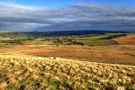
High Pike (658 metres) lies in the northern fells of the Lake District. The fells at the back o' Skiddaw offer excellent walking with views to the Lake District fells and north across the Solway Firth to the Scottish hills. This route should be avoided in poor visibility as the terrain can be confusing with few obvious landmarks. The ascent route involves a steady climb with only a few steeper sections. Much of area crossed was subject to mining although today nature has reclaimed many of the scars.
The start is the small parking are at Fell Side (grid ref. NY305375) which lies on the south side of the lane around the northern perimeter of the National Park. After parking walk south up the tarmac track and either cross the stile or pass through the gate into open country. Turn right along a clear track and after 75 metres turn left onto a grassy rising path. After 500 metres you reach a fork with a waymark. Bear left and continue across moorland to reach a cross path after 400 metres (grid ref. NY312368). Bear half right and continue uphill to cross a clear stony cross track. There is evidence of former mining activities on this section of the route with danger areas enclosed by fences.
Continue along the grassy path over Deer Hills and continue to climb reaching a cross path (grid ref. NY318358). Ahead lies the final climb onto High Pike. Pass the remains of an old hut and continue the short way to the summit with its OS trig column and rudimentary stone shelter. The view is excellent with many of the northern Lakeland fells lying to the south. The northern panorama is equally fine with the Solway Firth and Scottish hills in view.
To start the descent head northeast down a grassy path which leads down to a clear track which once served the mines. Bear left and ignoring paths to the right continue for 700 metres to a clear junction of tracks (grid ref. NY328364). Turn sharp left and continue to just before Potts Gill (not named on OS maps) and a complex junction of tracks with adjacent piles of rubble. Turn right and after 250 metres fork left off the main track onto a clear path. Follow this until it nears the main track and turn sharp left at a wall corner. Follow the path beside the wall to the next wall corner and walk ahead to cross Potts Gill. Follow the path heading west to pass Little Fellside Farm on your right. Join the farm's access drive for about 400 metres before veering left off the track along a grassy path. Drop down to a beck and climb up the other side and continue to reach a clear track used at the start of the walk. Turn right through the gate to return to the parking area at Fellside.
Maps 

| Ordnance Survey Explorer OL5 | Sheet Map | 1:25k | BUY |
| Anquet OS Explorer OL5 | Digital Map | 1:25k | BUY |
| Ordnance Survey Digital Map Subscription | |||
| Latest Ordnance Survey Discounts | |||
Other walks nearby
| Walk 2612 | Roughton Gill, Caldbeck Fells | easy | 4.5 miles |
| Walk 2351 | Caldbeck & Watersmeet from Hesket Newmarket | easy | 4.3 miles |
| Walk 1177 | Great Sca Fell via Trusmadoor | moderate | 6.5 miles |
| Walk 3283 | Great Cockup and Meal Fell from Longlands | moderate | 6.0 miles |
| Walk 1101 | Carrock Fell, High Pike and Knott | moderate | 11.0 miles |
| Walk 1214 | Carrock Fell & High Pike from Mosedale | moderate | 7.0 miles |
| Walk 2244 | Whitewater Dash and Great Calva | moderate | 7.0 miles |
| Walk 1354 | Bannerdale Crags & Souther Fell | moderate | 7.5 miles |
| Walk 1676 | Ullock Pike, Long Side and Carl Side | moderate | 5.5 miles |
| Walk 2040 | Ullock Pike & Carlside | moderate | 5.5 miles |
Recommended Books & eBooks
The Cumbria Way
 A guidebook to the 73 mile Cumbria Way, an easy long-distance walk though the heart of the Lake District National Park, from Ulverston in the south to Carlisle in the north, with good transport links to either end. The route is largely low-level but this guide offers alternative mountain days to climb some of the famous fells en route.
More information
Hadrian's Wall Path
 Hadrians Wall Path guidebook to walk the 84 mile National Trail. Described in both directions, the main description is west to east between Bowness-on-Solway and Wallsend, Newcastle, with extensions to Maryport and South Shields. With extensive historical information related to this World Heritage site and separate 1:25,000 OS map booklet included.
More information
