Napton-on-the-hill, Grand Union Canal & Beacon Hill
Warwickshire Walk
County/Area - Warwickshire
Author - Lou Johnson
Length - 7.4 miles / 12 km Ascent - 600 feet / 182 metres
Time - 4 hours 20 minutes Grade - easy/mod
Walk Route Description
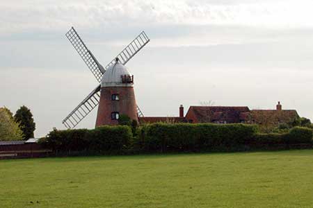
Click image to see photo description.
The Warwickshire countryside is never dramatic but often full of interest and this walk is no exception. The start is the village of Napton-on-the-Hill located just south of the A425 between Southam and Daventry. Limited on street parking is available (grid ref. SP465612) and you are asked not to inconvenience local residents. The walk starts from the junction of Hackwell Street (the main road through the village) and School Hill. From this junction take the enclosed footpath north to reach a track/lane. Turn left and follow this byway passing the parish church on your left and continuing along a driveway which leads to a house with a restored windmill on top of Napton Hill. Before reaching the house and windmill, which is private property, turn right onto the footpath which follows a rather convoluted route to reach a lane (grid ref. SP453613) passing an industrial area on the right.
Turn right along the lane, cross the canal and turn right onto the towpath along the Oxford Canal. You are now on the Oxford Canal Walk which is followed under the A425, and another two side roads to reach Napton Marina on your right. Continue past these moorings to reach the larger Wigrams Turn Marina, also on your right, and Napton Junction where the Grand Union Canal comes in from the left (grid ref. SP468625). Cross the footbridge over the Grand Union Canal and turn left. You are now heading north with the Grand Union Canal on your immediate left. Away to your left are Napton Reservoirs and you soon reach the first of the Calcutt Locks (grid ref. SP468633).
Leave the towpath here by taking the footpath on the right. This path leads across a field with the hedge line on your left to reach a junction with a bridleway (grid ref. SP469636). Turn right here for about a kilometre to join the access drive to Calcutt House Farm. Keep straight ahead and join a lane which is followed for a further 800 metres to reach the canal. Do not cross the canal bridge and turn left and follow the canal towpath (canal to your right) to a footbridge (grid ref. SP488628). Cross this footbridge and continue along the path into the village of Lower Shuckbrough and the main A425 road.
Cross this road with care and take the footpath opposite. The onward path heads south east skirting Park Lane Farm on your right to climb steadily onto the Shuckbrough Hills. Reaching a junction of paths (grid ref. SP495617) bear left and continue with woodland to your left to head southwest towards the summit of Beacon Hill with its trig point (grid ref. SP489609). At the corner of the woodland, turn right and descend across fields with the woodland on your right. Continue to a lane (grid ref. SP483610) with Halls Barn Farm on your left. Turn left along the lane almost immediately take the footpath on your right. This crosses the first field half left and continues across further fields to reach a lane (grid ref. SP472610). Cross this lane and continue along the path following a similar direction past a lake and through another field and out onto a lane (grid ref. SP469611). Cross the road and take the footpath opposite. Almost immediately take the footpath on your left, go half left across a field, cross a byway and continue through another field back to the starting point in Napton-on-the-Hill.
Maps 

| Ordnance Survey Explorer 222 | Sheet Map | 1:25k | BUY |
| Anquet OS Explorer 222 | Digital Map | 1:25k | BUY |
| Ordnance Survey Digital Map Subscription | |||
| Latest Ordnance Survey Discounts | |||
Other walks nearby
| Walk 1820 | Napton on the Hill circular | easy | 5.0 miles |
| Walk 3704 | Napton & Stockton Circular | easy | 6.4 miles |
| Walk 3690 | Lias and Stockton Locks Circular | easy | 5.3 miles |
| Walk 1070 | Hellidon & Priors Marston | easy | 5.7 miles |
| Walk 1819 | Long Itchington Circular | easy/mod | 6.5 miles |
| Walk 2813 | Long Itchington to Ufton and Return | easy/mod | 8.0 miles |
| Walk 1774 | Priors Hardwick & Wormleighton Circular | easy/mod | 8.0 miles |
| Walk 3701 | Upper Boddington Circular | easy | 5.5 miles |
| Walk 2276 | Oxford Canal & Stoneton | easy/mod | 7.0 miles |
| Walk 1790 | Byfield, Aston le Walls & Boddington Reservoir | easy/mod | 8.2 miles |
