Hellidon & Priors Marston
Northamptonshire Walk
County/Area - Northamptonshire
Author - Millennium Way
Length - 5.7 miles / 9.3 km Ascent - 370 feet / 112 metres
Time - 3 hours 10 minutes Grade - easy
Walk Route Description
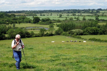
Click image to see photo description.
This circular walk corporates two idyllic villages, quiet country lanes, pleasant woodland, open countryside and an interesting church at Hellidon. A small section of the walk crosses Hellidon Lakes Golf Course, so extra care should be taken near the fairways. The walk starts and finishes at The Red Lion Inn at Hellidon where walkers and dogs are very welcome, but refreshment can also be obtained half way round at The Holly Bush in Priors Marston. There are no difficult sections on this walk and only six stiles. It includes a short section of The Millennium Way at Priors Marston, which is clearly waymarked with the distinctive black and white circular waymarkers.
A - We start our walk from The Red Lion Inn at Hellidon. With your back to the pub go up road directly opposite the front of the pub signposted Priors Marston 2 miles. After approx 100yds take the lane on the right and follow lane around to the left, signposted Priors Marston and Southam. Ignore footpath on left near the bend and continue ahead along the lane past the T-junction. (On your right you have some splendid views past Canning's Spinney to the north.) Pass the entrance to Hellidon Lakes Hotel and Golf Course and continue along lane until you reach the crossroads.
B - Turn right at crossroads and after 100 yds take stile and footpath left to go half right across field keeping the communication towers to your far left. As you descend down the field you can enjoy an attractive panorama of open countryside ahead. Continue gently downhill across the fields until you reach the road.
C - Turn left on road for approx 70 paces then take waymarked footpath right along the track at the end of which take a stile into field and continue quarter right towards corner of copse to take the gap into next field keeping fenced hedge and small lake on your left. Go through the two wooden gates ahead and turn immediately right keeping hedge right.
D - Here you have joined The Millennium Way. Continue with hedge right to cross stile in corner of field and follow the distinctive black and white Millennium Way waymarker, keeping ahead with hedge and fence right. After approx 100 yards, go past wooden gate then a few paces further on take stile right and then go through metal kissing gate and ahead along rather ill-defined grassy path into paddock. Go quarter left across paddock (or skirt around if horses are contained by electric fence) and exit by metal gate. Keep ahead half left on same line to take corner field footbridge over stream. Keep ahead with house left and after approx 100yds take stile left to track and then driveway to reach road.
E - Turn right on road ( you are now entering the village of Priors Marston ) and on reaching the T-junction bear left up road to pass the Priors Marston War Memorial on right and where the road divides take the right fork signposted Lower Shuckburgh and Napton. Continue along Shuckburgh Road passing telephone box on left and continuing past School Lane, St Leonards Close and Vicarage Lane on right. On reaching a red pillar box (we leave The Millennium Way here) continue to next junction and turn right up lane and after 50 yds take waymarked lane left. Stay ahead to the end of the lane and take gate to follow footpath under power lines across next field. Take next gate and cross farm track to go through another gate then continue ahead through small copse. Take metal kissing gate ahead and where paths divide take right hand footpath across field.
F - Go through gap ahead to cross small plank footbridge and continue directly ahead across centre of next field. Go through large five bar gate ahead then immediately leave cinder track to continue on previous line towards wood. Be sure to maintain a straight line towards centre of wood to find a gap (with large black & white waymarker) to enter wood. Go along well defined path through wood following signs, eventually to emerge by a small pond on right. Bear half right here to cross the golf course heading for the area of woodland ahead. The route is clearly marked by black arrows.
Continue through this small area of woodland and on emerging back on to the golf course, cross fairway towards small wooden bridge. Cross footbridge, then ahead across the next fairway and continue through the gap between two small lakes ahead of you. As you walk between the lakes, bear slightly right by the corner of woodland ( keeping lake right ) and continue ahead with wooded area left to cross next fairway to reach another waymarker post just beyond the green. Descend through small copse crossing wooden plank bridge, then over gap stile into field.
G - Go quarter right up the field to find top right corner kissing gate (ignore first wooden gate right, two-thirds up the field.) Take the corner gate and continue along edge of field with hedge left to take next kissing gate then follow path round with fence left to emerge onto road. Go left for 50 yds then right and continue down Church Lane, passing Berry Lane and Cox's Lane, until you reach the church. Go left through metal gate into churchyard of St. John the Baptist Church. Go past front door of church and continue downhill through churchyard to take steps down to lane. Turn right here to walk up the lane which will bring you back to your starting point at The Red Lion Inn.
Maps 

| Ordnance Survey Explorer 206 | Sheet Map | 1:25k | BUY |
| Anquet OS Explorer 206 | Digital Map | 1:25k | BUY |
| Ordnance Survey Digital Map Subscription | |||
| Latest Ordnance Survey Discounts | |||
Other walks nearby
| Walk 1790 | Byfield, Aston le Walls & Boddington Reservoir | easy/mod | 8.2 miles |
| Walk 3090 | Woodford Halse, Hellidon & Badby circular | moderate | 13.8 miles |
| Walk 3701 | Upper Boddington Circular | easy | 5.5 miles |
| Walk 2276 | Oxford Canal & Stoneton | easy/mod | 7.0 miles |
| Walk 2430 | Napton-on-the-hill, Grand Union Canal & Beacon Hill | easy/mod | 7.4 miles |
| Walk 1820 | Napton on the Hill circular | easy | 5.0 miles |
| Walk 3704 | Napton & Stockton Circular | easy | 6.4 miles |
| Walk 1774 | Priors Hardwick & Wormleighton Circular | easy/mod | 8.0 miles |
| Walk 2449 | Canons Ashby Circular | easy | 5.0 miles |
| Walk 1825 | Chipping Warden, Thorpe Mandeville, Culworth Circular | easy/mod | 10.0 miles |
