Hollingworthall Moor & Walkerwood Reservoirs
Greater Manchester Walk
County/Area - Greater Manchester - Tameside
Author - Mike Bexley
Length - 7.0 miles / 11.4 km Ascent - 975 feet / 295 metres
Time - 4 hours 30 minutes Grade - moderate
Walk Route Description
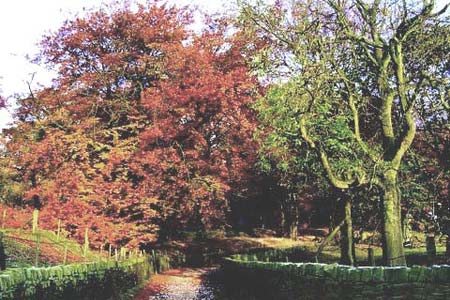
Click image to visit gallery of 6 images.
This is a great little walk. With the exception of the stretch on the moor and near the reservoirs there are views on your right all the time. When you reach the cairn towards the end, depending on the day the view of the Peaks is stunning, yet it's not a high walk and it is within a few miles of a Motorway. This walk, so near to the large towns of Stalybridge and Mossley, Greater Manchester is a classic. If its views you want - there are plenty, if it is the desolate moor you want - it is there. The walk is on good clear footpaths and the map reading is easy. There is only one problem it can be wet under foot so good footwear is a must or alternatively choose a dry spell.
Start at the top of Hobson Moor Road (grid ref. SJ995972). This is only two miles from the end of the M67. Head off in a northwesterly direction, walking past the 'Private Road/Footpath Only' sign to Hall Farm (grid ref. 002977). The converted Hall Farm is at the end of a private drive again signed 'Footpath Only'. On reaching the farm entrance take the left path between the farm and the barn development climbing slightly. Then follow the bridleway straight on. This contours the hill, offering superb views to your right over the Peak District.
On reaching the first finger post sign (grid ref. 007986), turn left and climb up the hill keeping the wall on your right. Then it is over the stile at the top to drop down to the twin Swineshaw Reservoirs. Follow the path which bears to the right and finishes at the foundations to an old building, before making your way down to the five-bar metal gate you can see. This in turn leads to a lane and the road over the dam wall (grid ref. 006996).
Cross over the dam and take the Land Rover track to the right. This track this passes an old wire wrapped building on the left. Staying on this track over the moor you eventually drop down the other side (grid ref. 994003) with further views, this time of Mossley and beyond. Keep to the main track to reach a metal gate continuing straight on to pass cottages on both sides of the track. Take the footpath, indicated with a finger post, on your left. This green path with a fence on your right takes you to Walkerwood Reservoir.
The path joins a road. At the gates turn right down a footpath to the head of the reservoir. The path swings round to the other side and closely follows the boundary fence of the reservoir (note - this lower path is not marked on the map). On reaching the road and 'Stalybridge Country Park' sign keep to the path over the wet ground bridges to turn left at the finger post sign (grid ref. 984987).
Climb up the hill over the stile and straight on to pass through the butts of an old rifle range. This path leads to a stile under electric transmission lines. Keep straight on up the narrow path ahead climbing up to the 'Ashtonhill Cross' buildings and finger posts (grid ref. 982977). Turn left up the metallic road which serves the covered-over spring on your right. Keep straight on up the fields to a stile and continue up the hill ahead to the cairn at the top. Cross over the track to follow the path straight on. A couple of gates in the wall leads you to down some steps to Moorside Farm (995975). Turn right to follow their road back to your start.
Maps 

| Ordnance Survey Explorer OL1 | Sheet Map | 1:25k | BUY |
| Anquet OS Explorer OL1 | Digital Map | 1:25k | BUY |
| Ordnance Survey Digital Map Subscription | |||
| Latest Ordnance Survey Discounts | |||
Other walks nearby
| Walk 3607 | Reservoirs Walk from Tintwistle | easy/mod | 5.5 miles |
| Walk 1703 | Longdendale from Hadfield Station | easy/mod | 9.0 miles |
| Walk 2637 | Coombs Ridge, Cown Edge from Broadbottom | easy/mod | 7.0 miles |
| Walk 1686 | Cown Edge | easy/mod | 7.3 miles |
| Walk 1759 | Torside Clough & Longendale from Old Glossop | moderate | 7.4 miles |
| Walk 1168 | Old Glossop & Bleaklow | moderate | 9.5 miles |
| Walk 2517 | Chew Reservoir & Fox Stone from Dovestones | moderate | 7.5 miles |
| Walk 2553 | Greenfield Reservoir & Raven Stones from Dovestone | moderate | 8.0 miles |
| Walk 1923 | Cown Edge & Whiteley Nab from Chunal | easy/mod | 6.5 miles |
| Walk 2625 | Torside Clough from Longdendale | moderate | 4.5 miles |
