Golden Cap & Charmouth
Jurassic Coast Walk
Region - Jurassic Coast
County/Area - Dorset
Author - Reg Carr
Length - 5.0 miles / 8.1 km Ascent - 1200 feet / 364 metres
Time - 3 hours 40 minutes Grade - easy/mod
Maps 

| Ordnance Survey Explorer 116 | Sheet Map | 1:25k | BUY |
| Anquet OS Explorer 116 | Digital Map | 1:25k | BUY |
| Ordnance Survey Landranger 193 | Sheet Map | 1:50k | BUY |
| Anquet OS Landranger 193 | Digital Map | 1:50k | BUY |
Walk Route Description
Click image to see photo description.
From A35 take slip road into Charmouth and at south end of village look for National Trust sign to Stonebarrow Hill. Go carefully up a very narrow lane until this opens out onto a grassy area on Stonebarrow Hill. This is the car park and provides a convenient start to the walk (Grid ref. SY389935). This is a good area for a picnic and a lazy afternoon on a warm summer's day. This walk is in a quiet part of West Dorset and offers good coastal and country views.
Leave the car park and walk east along the track until you reach a gate (Grid ref. SY396935) and follow the path down the hill. The path becomes a track down to a farm at Upcot (Grid ref. SY396930). After the farm turn right across the field on a path which joins a narrow road (Grid ref. SY399927) and go right on this down to the hamlet of St Gabriel.
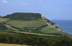
This was once a much larger village but much of it fell into the sea because the Blue Lias clays here are very unstable. Go past the cottage and the ruined church on the left and then take the path on the right which goes steeply up the hill to the crest of Golden Cap (Grid ref. SY406922).
Golden Cap is the highest cliff on the south coast of England and is 191m above sea level. There can be brilliant views from the crest but keep well clear of the cliff edge. To the west you see Charmouth and Lyme Regis and to the east Seatown, Bridport and Chesil Beach.
Continue along to the Trig Point and go down the steps and made up path, and across the stile. Continue straight across to the wood (Langdon Hill - Grid ref. SY411923 and not to the right which will take you down into Seatown with a consequent steep climb back up!
Walk through the wood and on to the track at the north end. Go north until it joins a narrow road (Grid ref. SY411933) and turn left on this road. Continue past Norchard Farm to Upcot (Grid ref. SY396930) and then back up the track to the car park on Stonebarrow Hill.
Other walks nearby
| Walk 1551 | Seatown and Charmouth via Golden Cap | easy/mod | 5.0 miles |
| Walk 1549 | Golden Cap from Seatown | easy/mod | 4.0 miles |
| Walk 2771 | Lyme Regis & Uplyme Circular | easy/mod | 5.5 miles |
| Walk 1550 | Charmouth & Lyme Regis Circular | easy/mod | 6.0 miles |
| Walk 2391 | West Bay & Burton Cliff | easy | 4.5 miles |
| Walk 3629 | Eggardon Hill from Loders | moderate | 8.4 miles |
| Walk 3265 | Eggardon Hill from Powerstock | easy/mod | 6.3 miles |
| Walk 1795 | Beer & Branscombe Circular | easy/mod | 5.5 miles |
| Walk 2565 | Littlebredy from Abbotsbury | moderate | 8.5 miles |
| Walk 2827 | Rodden & Langton Herring from Abbotsbury | easy/mod | 9.2 miles |
Recommended Books & eBooks
South West Coast Path Map Booklet - St Ives to Plymouth
 Map of part of the southern section of the 630 mile (1014km) South West Coast Path National Trail. Covers the trail from St Ives to Plymouth along the west Cornwall and Devon coastline. This convenient and compact booklet of Ordnance Survey 1:25,000 maps shows the route, providing all of the mapping you need to walk the trail in either direction.
More information
The South West Coast Path
 Guidebook to walking the entire South West Coast Path National Trail. The route runs for 630 miles from Minehead to Poole along the north Devon, Cornish, south Devon and Dorset coastline. Divided into 45 stages, this long-distance coastal trek could be completed within 4 weeks, or walked in sections. Guide includes maps and essential information.
More information
Messaging & Social Media
Message Walking Britain and follow the latest news.

Mountain Weather
Stay safe on the mountains with detailed weather forecasts - for iOS devices or for Android devices.