Beaconsfield Circular
Chilterns Walk
Region - Chilterns
County/Area - Buckinghamshire - South Buckinghamshire
Author - Peter Smyly
Length - 9.0 miles / 14.6 km Ascent - 450 feet / 136 metres
Time - 5 hours 0 minutes Grade - easy/mod
Walk Route Description
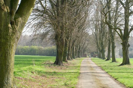
Click image to visit gallery of 6 images.
This is a circular walk through rural Buckinghamshire that starts and finishes at the town of Beaconsfield. Much of the route is along public footpaths, including part of the Chiltern Way. The route also goes along some quiet country lanes though one drawback is that it crosses the very busy Amersham Road twice. The route is described in an anti-clockwise direction, going east through the village of Seer Green, north through Hodgemoor Woods, north west to the village of Coleshill and finally south through woodland back to the start point. Gradients are mostly gentle with the occasional uphill stretch, but none of it difficult. Beaconsfield has a railway station and a car park and this is where the walk starts, following the signs for the Model Village.
A walk through the residential area north of the station leads to Wilton Road and a right turn along Ledborough Lane. Follow this road almost as far as the T junction with Amersham Road, then take a footpath to the north across an open field which later borders a hedgerow on the right. Take the first turning on the right along a tree-lined avenue to Amersham Road. Having carefully crossed this busy road, a path leads through woodland. Follow the route ahead, emerging into the open briefly across a field before continuing downhill through more woodland and at the bottom of the slope, follow the path ahead up a sloping field. At the top of the rise, the path crosses another field with the houses of Seer Green now in view ahead.
On leaving the field, at Bottom Lane, turn left along the road which shortly turns right up a slight hill. Take a narrow signposted public footpath on the left, which could easily be missed, and which leads away from Seer Green. Horses grazing in fields may be seen and there are a few wooden stiles to cross. The path passes the Princess Marina Centre on the right, just before it reaches Rawlings Farm. A right turn here along a narrow tarmac road leads to Hodgemoor Woods on the left. The next aim is to reach the car park by heading more or less due north. Hodgemoor Woods is crossed by a number of similar-looking footpaths. Of possible interest are a few bowl-shaped depressions that may have been caused by flint-mining activities in the past. At the car park, bear right to locate a narrow lane bordered by woodland on the left and a hedge on the right as the road goes downhill. This road connects with the Chiltern Way, signposted on the left.
The route from here to Coleshill is straightforward and it passes Brentford Grange Farm on the right; from near here, a windmill is seen on the far horizon ahead. A tree-lined path ahead leads to the second crossing of Amersham Road, then it continues on the other side of the road, bordering a field before reaching the village of Coleshill where there is a church, a pub and a duck pond with some weeping willow trees bordering the water to one side. Following the road through the village due south leads to a point where the windmill can be seen on the left but it is on private land and this is the closest view of it on this route. At the foot of the hill there is a traffic island at a T junction and, almost directly ahead is the path to follow next, due south. Turn right at Luckings Farm to reach Coleshill Lane. At the bend in the road at Marron's Bottom, follow a path due east initially, leading to another path due south through Great Beard's Wood followed by Netherland's Wood. These are the names of the woods as shown on the map, though the main focus is on heading due south to return to Beaconsfield by following a footpath through woods. Now continue to follow the path ahead through woodland for the next mile or so until the houses of Beaconsfield appear ahead and retrace the route back to the start point.
Maps 

| Ordnance Survey Explorer 172 | Sheet Map | 1:25k | BUY |
| Anquet OS Explorer 172 | Digital Map | 1:25k | BUY |
| Ordnance Survey Digital Map Subscription | |||
| Latest Ordnance Survey Discounts | |||
Other walks nearby
| Walk 1373 | Amersham Old Town Circular | easy/mod | 11.5 miles |
| Walk 1780 | Warren Wood and Little Marlow | easy | 4.4 miles |
| Walk 2928 | Amersham to Chorleywood via Chalfont St Giles | easy/mod | 8.5 miles |
| Walk 1517 | Amersham circular via Hyde Heath and Little Missenden | easy/mod | 8.0 miles |
| Walk 3420 | Cookham to Gerrards Cross via Burnham Beeches | moderate | 12.5 miles |
| Walk 1071 | Chalfont & Latimer, Chalfont St Giles & Chorleywood | easy/mod | 12.6 miles |
| Walk 1536 | Sarratt Bottom and Chenies from Little Chalfont | easy/mod | 6.3 miles |
| Walk 1568 | Chalfont and Latimer, Flaunden and Chorleywood | moderate | 11.7 miles |
| Walk 3443 | Chalfont & Latimer, Latimer and Flaunden | moderate | 13.7 miles |
| Walk 1149 | Chesham to Rickmansworth (Chess Valley) | easy/mod | 10.5 miles |
