Ampleforth, Shallow Dale, Yearsley Moor & Wilderness
North York Moors Walk
Nat Park - North York Moors - North York Moors West
County/Area - North Yorkshire
Author - Phil Catterall
Length - 9.5 miles / 15.4 km Ascent - 1370 feet / 415 metres
Time - 6 hours 10 minutes Grade - moderate
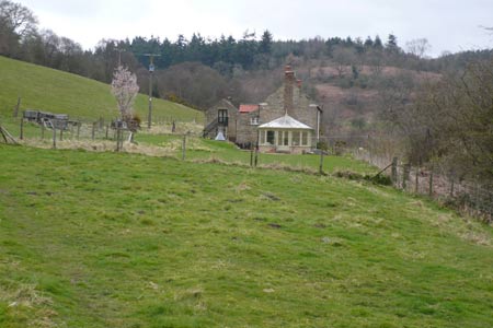
Walk Route Description
Click image to visit gallery of 5 images.
A circular walk mostly in the Howardian Hills AONB and touching the North York Moors National Park. The walk starts from the south side of Ampleforth Village (grid ref. SE582781). Suggested parking place is the wide grass verge. Cross the road to take the rerouted public footpath going NNW, crossing two footbridges to reach the Ampleforth to Wass road. Turn left here walking uphill, ignoring the first lane on your right signposted Hambleton. Take the lane immediately after this to High Woods. The lane is steep and passes a sawmill. With the steep ascent, Shallow Dale is soon below you as the track turns left at grid reference SE568799.
Just before High Woods Farm go through the waymarked gate on your right. Once the farm is passed continue heading south skirting the left flank of a hill to reach Burtis Wood (grid ref. SE564791). The path through the wood is marked by painted white spots on the trees. Caution is needed as you head towards the bottom of the wood as there are some steep banks. Our group of eleven walkers did not have any problems in wet conditions, but go careful. As you leave the wood look diagonally left to the next hedgerow for a gate. Take this footpath through small fields with several stiles to emerge onto the Wass road at Jerry Carr Bank (grid ref. SE572786). Then it is 150m uphill to take the footpath on your right signposted as going to Colley Broach Road.
The view opens up here, dropping downhill first and keeping well to the left of a solitary barn as you now climb uphill on pasture land (no defined path). As you go over the top to drop downhill a path junction appears and we go left though gateposts at grid ref. SE566782. Keep to the left fence line and you soon see a waymarked stile. Continue to the field boundary at grid ref. SE569779 where you turn right and head downhill to join the track to pass by Old Pilfit Farm. At Colley Broach Road (grid ref. SE567769) turn left. This road is gated and you can pick out where the old railway crossing from the Gilling to Pilmoor Junction railway line was located. The King passed through here by train on March 22nd 1944.
At the road junction (grid ref. SE571764) take the track to Low Lions Lodge - a working farm, passing in between barns to a gate, and then heading south east through fields - note it may be better to take the eastern edge if the field is cropped as it was when I did this walk. We soon start to ascend at Gask and are rewarded at the top with an excellent view on a clear day to Byland Abbey and The White Horse of Kilburn. It seems sensible to turn left at grid ref. SE576755 and go east to reach the lane at SE577755. This saves an up and back walk to High Lions Lodge, although the gateposts there are certainly interesting if you don't mind the walk (see photo).
Turn right when you reach the lane and walk uphill for 600m. Turn left into a well maintained forestry road on Yearsley Moor for 1.5 Km, which leads down to an area known as The Wilderness and the Lower and Higher Fish Ponds. At grid ref. SE595758 take a path left and then sharp right into the trees leaving the track which sweeps to the right. We now traverse between the two Higher Fish Ponds, turning left after 100m to follow the lakeside for 150m. We then join the track which takes us through forestry to the bank of the Lower Fish Pond. Follow the bank turning left along the straighter north end of the pond. Half way along the bank an unmarked track takes you right to join an access track at grid ref. SE590767. Ampleforth College can be seen in the distance.
Go straight across the access track to follow the left side of the field NNW, to again cross the path of the former railway line (see photo of sign here). A small gated conservation area is now encountered, and once this is behind you it is a straight run back to Ampleforth village, which can be seen 1 km to the north. Once the houses and road are reached turn left to walk 200m to our start point.
Maps 

| Ordnance Survey Explorer 299 | Sheet Map | 1:25k | BUY |
| Anquet OS Explorer 299 | Digital Map | 1:25k | BUY |
| Ordnance Survey Explorer 300 | Sheet Map | 1:25k | BUY |
| Anquet OS Explorer 300 | Digital Map | 1:25k | BUY |
| Ordnance Survey Digital Map Subscription | |||
| Latest Ordnance Survey Discounts | |||
Other walks nearby
| Walk 1704 | Oswaldkirk, Nunnington & Harome circular | moderate | 11.5 miles |
| Walk 1525 | Beck Dale & Rievaulx from Helmsley | moderate | 9.8 miles |
| Walk 2566 | Rievaulx Abbey from Kilburn, near Thirsk | mod/hard | 15.0 miles |
| Walk 1498 | Kilburn White Horse, Cold Kirby, Murton, & Sutton Bank | moderate | 14.0 miles |
| Walk 1524 | Cold Kirby, Rievaulx Bridge & Wass | moderate | 12.5 miles |
| Walk 3581 | Gormire Lake from Sutton Bank National Park Centre | easy/mod | 3.4 miles |
| Walk 2760 | Riccal Dale & Howl Dale | moderate | 8.2 miles |
| Walk 1920 | Rievaulx Moor from Cowhouse Bank | moderate | 9.5 miles |
| Walk 1311 | Slingsby & South Holme | easy/mod | 8.0 miles |
| Walk 1622 | Hawnby, Bilsdale West and Wetherhouse Moors | moderate | 8.3 miles |
Recommended Books & eBooks
Trail and Fell Running in the Yorkshire Dales
 Guidebook to 40 of the best trail and fell runs in the Yorkshire Dales National Park. Ranging from 5 to 24 miles, the graded runs start from bases such as Ribblehead, Dent, Sedbergh, Malham and Grassington and take in the region's diverse delights, from castles and waterfalls to iconic mountains such as Whernside, Ingleborough and Pen Y Ghent.
More information
