Fleetwith Pike and Buttermere Circular
Lake District Walk
Nat Park - Lake District - Lake District Western Fells
Wainwrights - Fleetwith Pike
County/Area - Cumbria
Author - Lou Johnson
Length - 8.5 miles / 13.8 km Ascent - 2550 feet / 773 metres
Time - 6 hours 50 minutes Grade - mod/hard
Maps 

| Ordnance Survey Explorer OL4 | Sheet Map | 1:25k | BUY |
| Anquet OS Explorer OL4 | Digital Map | 1:25k | BUY |
Walk Route Description
Click image to see photo description.
This Lake District walk is full of interest including beautiful Buttermere and the surrounding fells. The route also includes an ascent of Fleetwith Pike with its grandstand view across Buttermere and a 360-degree panorama including many of the high summits of the Lake District Western and North-Western Fells including Alfred Wainwright's favourite Haystacks.
The start is the pay and display car park in Buttermere village (grid ref. NY173169). Exit the car park and return to the main road through the village (B5289). Turn right and then after a few metres turn right again into a lane between buildings. At the first footpath junction (grid ref. NY177167) turn right and follow the path on the shores of Buttermere. As you make progress along the lakeshore your first view Fleetwith Pike appears ahead. The path eventually leads to the B5289 once more.
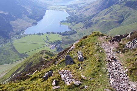
Turn right along the road, walk past the building at Gatescarth and take the track on the right after 150 metres. Almost immediately, turn left on a narrow path. From here, Fleetwith Pike is a daunting prospect yet its ascent is interesting and quickly achieved despite an ascent of over 500 metres. The climb starts immediately after leaving the road and soon passes a memorial cross. The path is steep in places but there are many excuses to pause to look back towards Buttermere and the surrounding fells. From the summit (grid ref. NY205141) the view down the length of Buttermere is superb.
From the cairn follow a narrow path initially descending south soon heading south east. There are several paths and the best option is to follow the most used. Continue the descent to reach a broad quarry track (grid ref. NY212135). Turn right and then after passing the Dubs Hut on your right, descend left. Nearing the bottom of the slope, veer off to the right across wet ground, cross Warnscale Beck and follow the path leading downhill. Cross the footbridge over Warnscale Beck, and continue ahead to join a clear track (grid ref. NY198138). Turn left down the track and continue to road at Gatescarth.
Turn left along the road. Take the path signed to "Buttermere and Ennerdale" on the left. Follow the broad path across pastures and over Peggy's Bridge. At the next footpath junction, turn right to follow the shoreline path along Buttermere. Where the path divides you can take either path but bear in mind the right-hand fork follows a line closer to Buttermere. At the end of the lake, turn right crossing Sourmilk Gill and Buttermere Dubs. At the end of the hedge on your left, turn left through a gate and follow the broad track back into Buttermere village. It is worth pausing on this final stretch of the walk to look back at Fleetwith Pike with a feeling of satisfaction that you have completed the circuit.
Other walks nearby
| Walk 2642 | Buttermere Horseshoe | very hard | 14.0 miles |
| Walk 2539 | Grasmoor and Rannerdale Knotts | moderate | 8.0 miles |
| Walk 1732 | Coledale and Newlands circular from near Buttermere | hard | 9.0 miles |
| Walk 1011 | Knott Rigg and Ard Crags | easy/mod | 3.5 miles |
| Walk 1231 | Grasmoor via Whiteless Pike | moderate | 7.0 miles |
| Walk 2020 | Rannerdale Knotts and Crummock Water from Cinderdale Common | easy/mod | 2.5 miles |
| Walk 1153 | The High Stile Ridge | hard | 10.0 miles |
| Walk 1289 | Fleetwith Pike & Haystacks | moderate | 5.5 miles |
| Walk 2021 | Whiteside, Hopegill Head & Grisedale Pike | moderate | 7.5 miles |
| Walk 3676 | Hen Comb from Loweswater | moderate | 5.4 miles |
Recommended Books & eBooks
Hadrian's Wall Path
 Hadrians Wall Path guidebook to walk the 84 mile National Trail. Described in both directions, the main description is west to east between Bowness-on-Solway and Wallsend, Newcastle, with extensions to Maryport and South Shields. With extensive historical information related to this World Heritage site and separate 1:25,000 OS map booklet included.
More information
Walking the Lake District Fells - Langdale
 Part of the Walking the Lake District Fells series, this guidebook covers a wide range of routes to 25 Lakeland summits that can be climbed from the Great Langdale valley, Ambleside and Grasmere, with highlights including Scafell Pike, Bowfell, the Langdale Pikes and Helm Crag (the Lion and the Lamb). Includes suggestions for longer ridge routes.
More information
Messaging & Social Media
Message Walking Britain and follow the latest news.

Mountain Weather
Stay safe on the mountains with detailed weather forecasts - for iOS devices or for Android devices.