Norbury Park Circular
Woodland Walk
Surrey Walk
County/Area - Surrey
Author - Lou Johnson
Length - 4.0 miles / 6.5 km Ascent - 450 feet / 136 metres
Time - 2 hours 30 minutes Grade - easy
Walk Route Description
Click image to see photo description.
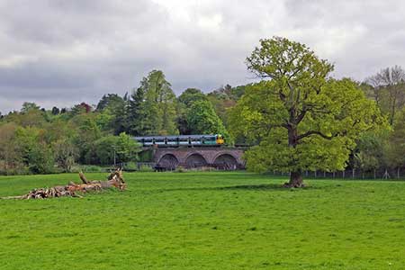
A circular walk in the North Downs from Box Hill & Westhumble station exploring the Mole Valley and Norbury Park. The river Mole is a tributary of the Thames and runs north through the Mole Gap. Norbury Park surrounds an 18th century mansion which today is owned by the Surrey Wildlife Trust. The route also includes a viewpoint over the valley and surrounding downs. Trains from Victoria and Waterloo provide easy access to the area with a journey time of under an hour.
Exit Box hill and Westhumble station (grid ref. TQ167519) and turn left to cross the railway. Almost immediately turn right onto a signed footpath heading north running parallel to the railway. The path crosses a footbridge over the River Mole beside the railway viaduct and 150 metres later veers half-left across a field. The path leads to a lane. Turn right and continue to Cowslip Farm. Turn left (signed to Leatherhead) along a track which soon recrosses the river. Pass to the left of Lodge Farm and keep ahead to reach a picnic area on the edge of the woodland. Go through the gate and continue for 600 metres uphill to a bridleway junction just on the edge of the trees (grid ref. TQ165539).
Turn left along the bridleway climbing steeply to pass a communication tower to a path junction at the top of the climb. Continue ahead beside a fence. Pass the entrance to Norbury Park House and join a tarmac drive. Turn left uphill and after 300 metres reach the Sawmill picnic area (grid ref. TQ158538). Fork left in front of the picnic area along a track past the sawmill (on your right). A short diversion to the left leads to a viewpoint where the panorama includes Box Hill, the Mole Valley, and the Mole Gap.
After enjoying the view return to the main path and continue past a bridleway coming in on the right. When the track bends left, veer right to stay on the approved route which runs just inside the woodland and descends to a small car park on Crabtree Lane (grid ref. TQ158524). Turn left down the lane which leads downhill back to Box Hill and Westhumble station.
Maps 

| Ordnance Survey Explorer 146 | Sheet Map | 1:25k | BUY |
| Anquet OS Explorer 146 | Digital Map | 1:25k | BUY |
| Ordnance Survey Digital Map Subscription | |||
| Latest Ordnance Survey Discounts | |||
Other walks nearby
| Walk 1618 | The Box Hill Hike | mod/hard | 8.0 miles |
| Walk 3610 | Ranmore Common Circular near Dorking | easy | 5.2 miles |
| Walk 1447 | Tadworth Circular | easy/mod | 8.5 miles |
| Walk 2124 | Leith Hill and Box Hill, two of the Surrey Hills | moderate | 12.5 miles |
| Walk 2102 | Leith Hill circular | easy | 1.5 miles |
| Walk 2683 | Farthing Downs and Happy Valley from Coulsdon South | easy/mod | 6.0 miles |
| Walk 1734 | Hampton Court Parks and Gardens | easy/mod | 6.5 miles |
| Walk 1869 | Thorncombe Street from Bramley | easy/mod | 6.0 miles |
| Walk 2479 | Worth Way from Three Bridges, near Crawley | moderate | 14.0 miles |
| Walk 1714 | Virginia Water & the Wentworth Estate | easy/mod | 9.0 miles |
