Kinver Edge circular
Staffordshire Walk
County/Area - Staffordshire - South Staffordshire
Author - Lou Johnson
Length - 4.2 miles / 6.8 km Ascent - 600 feet / 182 metres
Time - 2 hours 40 minutes Grade - easy
Walk Route Description
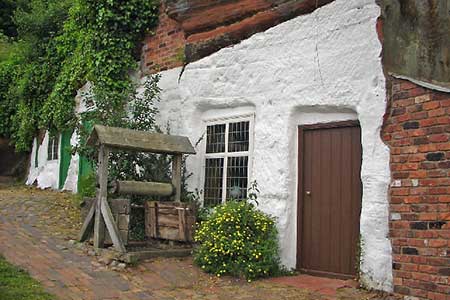
Click image to see photo description.
Located in South Staffordshire near the border with Worcestershire, Kinver Edge is a high heath and woodland escarpment owned by the National Trust just west of Kinver, about four miles west of Stourbridge. This walk offers the opportunity to visit the Holy Austin Rock Cottages which are cliff houses cut out of the red sandstone.
The start is the National Trust carpark on Compton Road just to the west of the centre of Kinver village (grid ref. SO836836). From the car park follow the waymarks up to the viewpoint. After enjoying the view walk south-west along the edge soon joining the Staffordshire Way. After 800 metres you reach a junction with the North Worcestershire Path with a convenient bench close by the junction (grid ref. SO829822). Turn left here are follow the North Worcestershire Path downhill for 150 metres and a cross path. Turn right and follow the path to reach the road in Blakeshall (grid ref. SO831813).
Continue down this lane in a southerly direction and turn right along a track to pass in front of Blakeshall House Lodge (which is on your right) to reach Solcum Lane (grid ref. SO829811). Turn right and almost immediately bear right on the waymarked path initially heading north-east but soon bearing left to reach a junction with the North Worcestershire Path (grid ref. SO825812). Turn right here and follow the path for just over a kilometre to reach the path junction passed earlier at grid ref. SO829822.
Turn left and continue downhill for about 50 metres. Then turn right passing Nanny's Rock Cave and keeping ahead at all path junctions to return to the car park.
Maps 

| Ordnance Survey Explorer 217 | Sheet Map | 1:25k | BUY |
| Anquet OS Explorer 217 | Digital Map | 1:25k | BUY |
| Ordnance Survey Digital Map Subscription | |||
| Latest Ordnance Survey Discounts | |||
Other walks nearby
| Walk 1806 | Kinver Stroll | easy | 2.0 miles |
| Walk 2024 | Kinver Edge, South Staffordshire | easy/mod | 6.0 miles |
| Walk 2874 | Enville Estate and the Sheepwalks | easy | 4.0 miles |
| Walk 1603 | Shatterford Wood and Castle Hill circular | easy/mod | 5.5 miles |
| Walk 1934 | Highgate Common and Surrounding Country | easy | 6.0 miles |
| Walk 2700 | Yieldingtree from Churchill | easy | 5.5 miles |
| Walk 2466 | The Severn Valley from Trimpley Reservoir | easy | 6.0 miles |
| Walk 1933 | Wyre Forest & River Severn from Upper Arley | easy/mod | 7.6 miles |
| Walk 2092 | Highley from the Severn Valley Country Park | easy/mod | 4.5 miles |
| Walk 3504 | Highley to Bewdley along the River Severn | easy/mod | 7.0 miles |
Recommended Books & eBooks
Walking in the Peak District - White Peak East
 Guidebook describing 42 half-day and day walks in the limestone landscapes of Derbyshire's White Peak, part of the Peak District National Park. One of two volumes, this book covers the east of the region, with potential bases including Bakewell, Eyam, Castleton, Birchover, Matlock and Wirksworth.
More information
