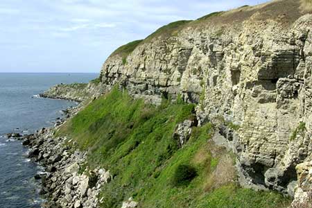
St Aldhelm's Head near Worth Matravers
Dorset Walk
County/Area - Dorset
Author - Lou Johnson
Length - 4.1 miles / 6.7 km Ascent - 600 feet / 182 metres
Time - 2 hours 40 minutes Grade - easy
Walk Route Description
Click image to see photo description.
This walk in Dorset's Isle of Purbeck includes an attractive section of coastal footpath along the limestone cliffs. In the past extensive quarrying of this rock was a major source of local employment and saw extensive use in major buildings through the British Isles. The start is a small carpark located just south of Renscombe Farm at grid ref. SY964773, which lies a mile or so west of the village of Worth Matravers.
To start the walk, exit the car park and take the signed footpath opposite. This leads across a large field with the hedge-line to your immediate left. Bear to the left around Weston Farm (grid ref. SY968773) to a lane. Bear right along the lane and after turn right down a lane with houses to your right. The lane soon bears left and then right before taking a meandering course down to the sea (grid ref. SY976761).
Turn left on to the South West Coast Path. This follows the top of the cliffs and takes you to St Aldhelm's Head where you can visit the former Coastguard Station. Continue along the South West Coast Path as it turns north. The path soon descends into a deep valley before climbing up onto the cliff tops. The views down to your left include the bay of Chapman's Pool with the Purbeck cliffs continuing westwards. Reaching a footpath junction (grid ref. SY959772) turn right signed to Renscombe. This leads back to the car park.
Maps 

| Ordnance Survey Explorer OL15 | Sheet Map | 1:25k | BUY |
| Anquet OS Explorer OL15 | Digital Map | 1:25k | BUY |
| Ordnance Survey Digital Map Subscription | |||
| Latest Ordnance Survey Discounts | |||
Other walks nearby
| Walk 2145 | Houns-tout Cliff from Kingston | easy | 3.5 miles |
| Walk 3286 | Dancing Ledge & Durlston Head from Langton Matravers | easy/mod | 7.0 miles |
| Walk 1331 | Kimmeridge & Tyneham | easy/mod | 6.8 miles |
| Walk 1534 | Swyre Head & Tyneham Cap from Kimmeridge | moderate | 11.8 miles |
| Walk 1995 | Houns-tout & Swyre Head from Kimmeridge | moderate | 8.7 miles |
| Walk 2579 | Purbeck Coast from Swanage | moderate | 10.0 miles |
| Walk 2568 | Egmont Point & Kimmeridge Bay from Tyneham | moderate | 14.0 miles |
| Walk 1533 | Gad Cliff, Povington Hill & Tyneham | easy/mod | 4.5 miles |
| Walk 1634 | Old Harry & Ballard Down from Studland | easy/mod | 5.3 miles |
| Walk 3396 | Agglestone & Old Harry Rocks | easy/mod | 6.4 miles |
Recommended Books & eBooks
Walking the Jurassic Coast
 This guidebook includes 30 walks on the Jurassic Coast of Devon and Dorset. Covering the coast between Exmouth and Bournemouth, these delightful routes range from 3 to 16 miles (5 to 24km), exploring and explaining the spectacular geology of this World Heritage area with clear, easily understood descriptions, cross-sections and timelines.
More information
