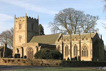
Romaldkirk Moor from Mickleton
North Pennines Walk
Region - North Pennines
County/Area - Durham
Author - Lou Johnson
Length - 7.6 miles / 12.4 km Ascent - 700 feet / 212 metres
Time - 4 hours 30 minutes Grade - easy/mod
Walk Route Description
Click image to see photo description.
The start of this walk is the small car park and picnic area to the south of Mickleton village (grid ref. NY968233) which is located beside the old railway line that once ran along this part of Teesdale. After parking walk northwest (with the village of Mickleton to your right) and continue along the trackbed of the old railway for about 500 metres to the first overbridge. Here leave the old railway and ascend to the lane. Turn left (southwest) and continue for just over half a kilometre to a road junction (grid ref. NY960232).
Turn left here and follow the gently rising lane south. Where the lane turns sharp left, continue ahead on the footpath taking a short cut across a field to re-join the lane at Swarthy Mere. Here head south following a clear track with a wall on your right. Continue with the wall on your right when the wall turns right (grid ref. NY961223) until reach a wall corner after a further 200 yards. From this point the right of way heads roughly south across rough pasture. The path is not clear on the ground and you will need to make your own way just east of south towards a gate in a cross wall (grid ref. NY962218). Go through the gate and with the wall on your right to reach a track (grid ref. NY963214).
Turn left along the track to a crossroads (grid ref. NY974217). Turn right here following a tarmac lane that descends past Currick Rigg on your left to a road junction (grid ref. NY980210). Turn right and then almost immediately left to join the access drive leading south to Gill Field Farm (grid ref. NY981203). Follow the path through the farmyard, over a stile, through a small gate and then over another stile to enter a large field. Aim half left across this field (roughly south-east), through a gate and continue in the same direction down to West End Farm. Here waymarks lead you through the farm and onto the access drive. After just over 600 metres by a small stream go through a waymarked gate on your right. Cross the field to reach an access gate to the Teesdale Railway Path. Turn left and follow the easy graded path to reach a lane and the end of the railway path (grid ref. NY992216).
Turn right along the lane into Romaldskirk village. Bear left along the B6277 at the first junction and continue into the centre of the village. Reaching a road junction, turn left along a lane. This leads to the continuation of the Teesdale Railway Path which is accessed on your right. Follow the clear path and continue for just under two miles to reach the small car park where the walk started.
Maps 

| Ordnance Survey Explorer OL31 | Sheet Map | 1:25k | BUY |
| Anquet OS Explorer OL31 | Digital Map | 1:25k | BUY |
| Ordnance Survey Digital Map Subscription | |||
| Latest Ordnance Survey Discounts | |||
Other walks nearby
| Walk 2157 | Romaldkirk & Cotherstone | easy | 5.0 miles |
| Walk 2170 | Eggleston & Mickleton from Romaldkirk | easy/mod | 5.8 miles |
| Walk 1005 | Harter Fell & Grassholme | moderate | 8.0 miles |
| Walk 1482 | Crossthwaite Common from Middleton-in-Teesdale | moderate | 9.8 miles |
| Walk 1483 | Eggleston & Romaldkirk from Middleton-in-Teesdale | easy/mod | 9.8 miles |
| Walk 1484 | Kirkcarrion from Middleton-in-Teesdale | easy | 3.5 miles |
| Walk 1485 | Hamsterley & Middleton-in-Teesdale | mod/hard | 16.5 miles |
| Walk 1488 | Middleton-in-Teesdale Railway Walk | easy | 2.5 miles |
| Walk 2258 | Grassholme Reservoir from Middleton-in-Teesdale | moderate | 8.2 miles |
| Walk 1553 | Hannah's Meadow, Baldersdale & Brown Rigg Moss | easy/mod | 8.0 miles |
Recommended Books & eBooks
Walking in the North Pennines
 This guidebook describes 50 day walks across the North Pennines, England's remotest Area of Outstanding Natural Beauty taking in parts of Cumbria, County Durham and Northumberland. Most of the routes are circular and they range from 5 to 14 miles, with something to suit all abilities. Route descriptions are accompanied by 1:50K OS mapping.
More information
Great Mountain Days in the Pennines
 An inspirational guidebook to 50 classic walks on the rolling Pennine landscape. The graded routes, between 6 and 13 miles in length, cover classic Pennine fells and moorland such as Whernside, Ilkley Moor and Pendle Hill; exploring the North and South Pennines, Yorkshire Dales, Howgills and Dark Peak. Many routes are also suited to fell running.
More information
