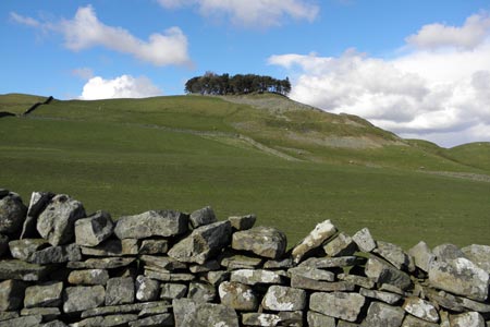
Kirkcarrion from Middleton-in-Teesdale
North Pennines Walk
Region - North Pennines
County/Area - Durham
Author - Steven Wallace
Length - 3.5 miles / 5.7 km Ascent - 600 feet / 182 metres
Time - 2 hours 20 minutes Grade - easy
Walk Route Description
Click image to visit gallery of 3 images.
From the market place turn down Bridge Street and cross the old county bridge over the River Tees. Built in 1811, it used to mark the boundary between the counties of Durham and Yorkshire. Walk up the hill until you come to the first road off to the right (signposted Holwick). Turn right and walk to the end of the house on the corner. To your left you will see a footpath sign for the Pennine Way through a wooden gate. Follow the track up the hill, keeping near the wall on the left. Reaching a green metal gate pass through and continue on the track curving round, keeping to the left when the track splits. Continue up the hill keeping Kirkcarrion in front of you and slightly to the right.
Kirkcarrion was named after a Brigantean prince who was said to have been buried here in pre-Roman times, but it is thought much more likely that a Bronze-Age tribal chieftain was buried in the barrow. His or someone else's ghost is still said to haunt the site on horseback.
Go over a stile beside a metal gate at the fence ahead. By now there are superb views back down the hill over Middleton and a good chance of seeing lapwings, curlews and hearing the skylarks up above. Once over the stile continue slightly left, still keeping Kirkcarrion to your right. Continue on the track, heading for the wall, which climbs up to Kirkcarrion. When you meet the wall you will see a metal gate, go through this and follow the farm track round the side of Kirkcarrion. Follow the track until you meet the road where there is a Bridleway sign by the gate.
Go through the metal gate, turning right and follow the road for 500 metres until you see a farm track on your right with a green metal gate and walls on both sides. This is Greengates Farm. Turn into the track and go through the farm yard, through another green gate. Take the right hand fork when the track forks, then through another green gate into a field. Follow the path, with the wall on your right for 200 metres until it curves round to the left. There is an old quarry above on your left, views of Grassholme Reservoir on your right and Kirkcarrion is now below you and slightly to the right.
As the path curves to the left there is a small hillock ahead of you. Look to the left of this and in the dip you will see a stone wall with a stile. Cross the field to the stile and go over it.
Now you go straight ahead meandering down the valley of Rams Gill with Middleton showing in front of you and Kirkcarrion behind. You will need to keep to sheep tracks at times since the centre of the dip can get boggy after wet weather. Continue straight ahead over a small rise until you can see the fence you crossed on the way up again. Now take the stile with dog gate next to the metal gate and follow the path down to the next metal gate, go through this keeping to the left hand path when the paths split.
Down to the wooden gate in the bottom right hand corner of the field and you are back on Holwick Road. Turn right, then left after the house on the corner and down the road to the bridge and back into Middleton.
This is one of a series of walks which form the Teesdale Challenge Walks Programme - there are many other excellent walks to choose from. Click here for full details of this walk
Maps 

| Ordnance Survey Explorer OL31 | Sheet Map | 1:25k | BUY |
| Anquet OS Explorer OL31 | Digital Map | 1:25k | BUY |
| Ordnance Survey Digital Map Subscription | |||
| Latest Ordnance Survey Discounts | |||
Other walks nearby
| Walk 2228 | Romaldkirk Moor | easy/mod | 7.6 miles |
| Walk 3099 | High Force, Low Force and the River Tees | easy/mod | 7.5 miles |
| Walk 2157 | Romaldkirk & Cotherstone | easy | 5.0 miles |
| Walk 2170 | Eggleston & Mickleton from Romaldkirk | easy/mod | 5.8 miles |
| Walk 1553 | Hannah's Meadow, Baldersdale & Brown Rigg Moss | easy/mod | 8.0 miles |
| Walk 3424 | Cronkley Fell | easy/mod | 7.0 miles |
| Walk 3526 | Hanging Shaw, Cronkley Scar, Low Force & High Force | moderate | 12.7 miles |
| Walk 2767 | Lartington & Cotherstone Circular | easy/mod | 6.8 miles |
| Walk 3634 | Catterick Moss & Bollihope Carrs | moderate | 5.6 miles |
| Walk 2469 | Great Allotment & God's Bridge | moderate | 10.2 miles |
Recommended Books & eBooks
Walking in the North Pennines
 This guidebook describes 50 day walks across the North Pennines, England's remotest Area of Outstanding Natural Beauty taking in parts of Cumbria, County Durham and Northumberland. Most of the routes are circular and they range from 5 to 14 miles, with something to suit all abilities. Route descriptions are accompanied by 1:50K OS mapping.
More information
Walking in County Durham
 Guidebook offering detailed descriptions of 40 day walks, plus 10 traffic-free cycle routes along old railway trackbeds. Together they cover 450 miles and spread all over County Durham to show the region's history and natural wonders. The terrain covered ranges from field paths to open moorlands, from the North Sea to the high Pennines.
More information
