Hamsterley & Middleton-in-Teesdale
North Pennines Walk
Region - North Pennines
County/Area - Durham
Author - Steven Wallace
Length - 16.5 miles / 26.8 km Ascent - 2650 feet / 803 metres
Time - 10 hours 50 minutes Grade - mod/hard
Walk Route Description
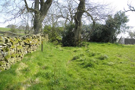
Click image to visit gallery of 10 images.
Leave Middleton on the main road in an easterly direction going past the Coop on the left, with the village green on the right. Follow the curve of the road round to the left and after the last house on the left, with pots of plants across a driveway, turn left to follow a footpath over a stile on the new wall and keeping to the right. Through another stile and continue up the right hand side of the field to the top.
Here you will find a gate with another stile beside it. Turn right along the track into a farmyard, turn left up between two barns, and go over a wooden gated stile at the top right hand corner. Cross the field to another stile in the right hand corner, take this into a narrow lane, now turn right before Stanhope Gate farmhouse and follow the farm track for two fields until you come to a footpath sign pointing into the field on your left. Go through the gate and cross the field to your right to a stile in the wall. Take this and cross the field to the top right to the gate. Go through the metal gate, turn left towards the house, cross the yard to the right and go through a wooden gate.
Now you turn up the field climbing steadily keeping to the wall on your right. Cross the next field still steadily climbing with the wall on your right until you reach the Stanhope road. Go through the gate and turn right onto the road. You will immediately see a footpath sign on the left ahead, go through the gate into the field.
Take the footpath across three fields, steadily climbing to an old ruined barn in the top left hand corner of the last field next to a small plantation. The path can be boggy here so you might want to take the track straight up and then turn left along, next to the wall. At the ruined barn, go through the building following the signs into a large field. From here you can see up Teesdale and across to Coldberry Gutter. Now follow the faint track keeping a few yards left of the stone wall along the top of the field. You will have a small beck to cross then Snailsgill Sike, in a deeper ravine. Keep to the wall until you come to a stile where the wall turns sharp right.
The next part of the walk is across heather and peat hags so take care. Cross the stile, turn left and keep near the wall for approx 1/4 mile then turn uphill, roughly north east, past a small cairn, keeping to the left of the cairn, following a faint track up to the escarpment on top of Monks Moor. Here you will pick up a track with cairns for a short distance taking you over to Great Eggles Hope. This part of the walk, down into the dale, is again over peat hags and can be very wet under foot except after dry weather. Take care as the going is rough. As you drop down into the dale make for a stile roughly opposite Wire Gill. Take the stile then drop down a steep path through high bracken, again taking care.
Follow the track down to the road to the left of disused mine buildings. Follow the road left crossing over Great Eggles Hope beck, a good place to stop for a bite, then follow the track uphill up Wire Gill. The track climbs steadily, go through a gate, then after approx 0.5 mile the track turns right although a footpath continues straight ahead. Take the track crossing the beck and continue in an easterly direction towards a tarn. On reaching the tarn follow the track around to the left and down to Candleseive Sike. Turn right through a gate onto another track, crossing the beck, and follow this to the road. Turn left and after 200 yards turn at the footpath sign to the right, following a track. Continue for 1.3 miles in an easterly direction along the track, with Sharnberry Beck starting as a trickle on your right and gradually turning into a bubbling beck. Keep to the main track when a turning forks to the left and take a wooden stile into Hamsterley Forest.
Continue on the track as it curves to the right and down, past a wooden bench, a welcome stop to look at the view. After 0.9 mile take the left hand path at the fork. After 0.6 mile take the Bridleway sign to the right, to the left is a sign for the visitor centre 4 miles. Climb the hill and follow the track for another mile, when you will see a Public Bridleway sign to the right.
Turn on to this path through the trees, a welcome change to have soft going after the hard paths of the last couple of miles. Climb steadily for approx 0.5 miles through the trees, and then go straight ahead again following a bridleway sign as you cross a forest track. Continue with more established trees on your right and young ones on the left for 200 yards until a final bridle path sign directs you down a narrow path, through a gate and over a beck out of the forest and onto Eggleston Common.
Follow the well-trodden path over the moors in a southwesterly direction. Here again you can see grouse, lapwing and maybe even golden plover. After 0.6 mile you join a wider way-marked track from the left. Continue along the track, which improves when it joins a wider track from the grouse butts, for 1.4 miles until you reach a metal gate next to sheep pens. Go through this gate then another still following the track down to the B6278 with you cross, taking the road downhill signed Middleton. You are now on the Teesdale Way.
Follow the road for 0.8 mile to the crossroads with B6282, cross the road down the track to Egglesburn Farm, keeping to the track curve right through a gate and continue along for 200 yards, taking the footpath to the right as the track curves left. Continue for 0.3 mile to the gate, go through then continue 100 yards to another gate, go through and continue straight ahead taking the footpath meandering next to the river.
After 200 yards cross a wooden footbridge and continue through a field, keeping to the path, then through a gate into the next field, still keeping the river on your left. The path goes up and down a few times as you cross various becks, but follow the river for 2 miles all the way round past the Leekworth Caravan and Camp site and below Middleton until you join the road at the bridge. Turn right into Bridge Street and follow the road up until you reach Horsemarket and are back in the centre of Middleton.
Maps 

| Ordnance Survey Explorer OL31 | Sheet Map | 1:25k | BUY |
| Anquet OS Explorer OL31 | Digital Map | 1:25k | BUY |
| Ordnance Survey Digital Map Subscription | |||
| Latest Ordnance Survey Discounts | |||
Other walks nearby
| Walk 2228 | Romaldkirk Moor | easy/mod | 7.6 miles |
| Walk 3099 | High Force, Low Force and the River Tees | easy/mod | 7.5 miles |
| Walk 2157 | Romaldkirk & Cotherstone | easy | 5.0 miles |
| Walk 2170 | Eggleston & Mickleton from Romaldkirk | easy/mod | 5.8 miles |
| Walk 1553 | Hannah's Meadow, Baldersdale & Brown Rigg Moss | easy/mod | 8.0 miles |
| Walk 3424 | Cronkley Fell | easy/mod | 7.0 miles |
| Walk 3526 | Hanging Shaw, Cronkley Scar, Low Force & High Force | moderate | 12.7 miles |
| Walk 2767 | Lartington & Cotherstone Circular | easy/mod | 6.8 miles |
| Walk 3634 | Catterick Moss & Bollihope Carrs | moderate | 5.6 miles |
| Walk 2469 | Great Allotment & God's Bridge | moderate | 10.2 miles |
Recommended Books & eBooks
Walking in the North Pennines
 This guidebook describes 50 day walks across the North Pennines, England's remotest Area of Outstanding Natural Beauty taking in parts of Cumbria, County Durham and Northumberland. Most of the routes are circular and they range from 5 to 14 miles, with something to suit all abilities. Route descriptions are accompanied by 1:50K OS mapping.
More information
Great Mountain Days in the Pennines
 An inspirational guidebook to 50 classic walks on the rolling Pennine landscape. The graded routes, between 6 and 13 miles in length, cover classic Pennine fells and moorland such as Whernside, Ilkley Moor and Pendle Hill; exploring the North and South Pennines, Yorkshire Dales, Howgills and Dark Peak. Many routes are also suited to fell running.
More information
