Camden Town to Baker Street
London Walk
County/Area - London
Author - Peter Smyly
Length - 2.5 miles / 4.1 km Ascent - 150 feet / 45 metres
Time - 1 hours 20 minutes Grade - easy
Walk Route Description
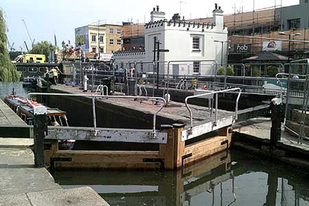
Click image to visit gallery of 8 images.
A walk that ends by "winding your way down on Baker Street" though you are unlikely to be "dead on your feet" given the shortness of the walk - a reference to some of the lyrics of the Gerry Rafferty song "Baker Street". Alternatively, you can conclude the walk by re-joining the London Underground network at Regent's Park or Great Portland Street stations. Although this walk only spans a couple of miles or so in central London, it reveals some of the more scenic aspects of the city.
On this walk you will get to visit the vibrant Camden Market, pass by part of Regent's Canal, walk uphill to the viewpoint of Primrose Hill and also pass through one of London's best-known parks, Regent's Park.
Start at Camden Town station on the northern line. Turn right out of the station and walk up Chalk Farm Road, leaving this road on the left at Camden Lock. Camden Market is open seven days a week so the hustle and bustle of it is pretty much unavoidable, but it does not last for long as, once past Camden Lock, you soon head away from the crowds and pass along the tow path by the canal away from Camden High Street. Leave the canal at Regent's Park Road on the right to locate Primrose Hill, also on the right and follow one of the tarmac paths to the top and pause here to enjoy the view. Some of London's best-known landmarks can be seen in the distance including the London Eye, the Shard building, St Paul's Cathedral and the BT Tower. Once you have had your fill of the view, go down the hill and exit at the south west corner of the green area. Cross the busy Albert Road at a zebra crossing and go right for a few yards before turning left to cross a bridge over the Regent's Canal. This way leads past the ZSL London Zoo, a glimpse of which can be seen on the left. Both Baker Street and Regent's Park stations are to the south of the park and it is a matter of choice as to which of the various paths to take en route. Two of the more attractive features of the park are the Queen Mary's Gardens and the boating lake.
Maps 

| Ordnance Survey Explorer 173 | Sheet Map | 1:25k | BUY |
| Anquet OS Explorer 173 | Digital Map | 1:25k | BUY |
| Ordnance Survey Digital Map Subscription | |||
| Latest Ordnance Survey Discounts | |||
Other walks nearby
| Walk 3379 | Euston to the Monument via St. Paul's | easy | 4.0 miles |
| Walk 1918 | Parliament Hill and the ponds of Hampstead Heath | easy | 3.5 miles |
| Walk 1096 | Highbury & Islington & New River | easy | 1.5 miles |
| Walk 1310 | Chancery Lane to Trafalgar Square | easy | 4.0 miles |
| Walk 1322 | Green Park to Trafalgar Square | easy | 2.5 miles |
| Walk 2360 | Green Park to Westminster via Sloane Square | easy/mod | 5.5 miles |
| Walk 3012 | Green Park to Trafalgar Square via Lambeth Bridge | easy | 4.5 miles |
| Walk 3698 | Central London from Green Park | easy | 5.2 miles |
| Walk 3013 | Trafalgar Square circular | easy | 3.0 miles |
| Walk 1442 | St Paul's Cathedral to Green Park | easy | 5.6 miles |
Recommended Books & eBooks
Walking in London
 A guidebook to 25 walks in London's green spaces and nature reserves, covering both the city centre and Greater London area. Taking in woods and forests, parks and heaths, canals and rivers, the guide includes a wealth of information about some of the species you might encounter as well as the history and conservation of these areas.
More information
