Llanfrynach and Pencelli circular
Brecon Beacons/Bannau Brycheiniog Walk
Nat Park - Brecon Beacons - Brecon Beacons Central
County/Area - Powys
Author - Lou Johnson
Length - 5.6 miles / 9.1 km Ascent - 600 feet / 182 metres
Time - 3 hours 20 minutes Grade - easy/mod
Walk Route Description
Click image to see photo description.
This Powys walk in the Brecon Beacons National Park was originally conceived for walkers staying at the Ty'n-y-Caeau Youth Hostel near Brecon. The walk has been amended to start at the A40 junction with the B4558 to Llanfrynach a few miles east of Brecon. For those staying at the Youth Hotel a further two miles and 100 feet of ascent must be added to the distance.
Parking is available by the canal bridge just south of the A40 alongside the B4558 (grid ref. SO077274). After parking walk south along the B4558 for just under 800 metres to reach a road junction (grid ref. SO075268). Bear right down the lane signed to Llanfrynach and continue for a further kilometre into the village. Just after passing the village sign, bear left down a signed track to the left of a stone built shed. This leads you into the churchyard. Continue past the church (on your right) and exit the churchyard onto a road. Turn right a walk past a terrace of cottages on your left.
At the first road junction bear left following the brown sign for the Taff Trail, which is located on a lamppost on the right. Continue along the lane soon passing a telephone box on your left. Reaching a lane on the right (grid ref. SO076255) after 250 metres continue straight ahead. After a further 500 metres you reach another road junction where you turn right (grid ref. SO079253) and continue to Pentwyn Farm. Pass through the farmyard following a track. After 200 metres or so, take the footpath on the left. Cross the field with the hedge on your left.
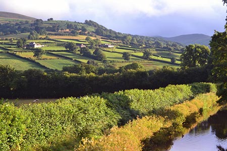
At the end of the field (grid ref. SO081247) enter the next field and head half right across the field to join a lane. Cross the lane and take the footpath opposite. This leads to a footbridge and a track that leads to a track. Walk past St Meugan's church on the let and continue to join a tarmac lane. After 700 metres you reach a T-junction. Turn right into the village of Pencelli soon walking beside the Monmouthshire and Brecon Canal on your left.
Turn left at the next junction and cross the canal. Bear right down an access path on the right just over the bridge and turn right along the canal which will be on your left. Stay on the canal towpath for two and a half miles to cross the River Usk on an aqueduct. At the next overbridge leave the canal and return to your car.
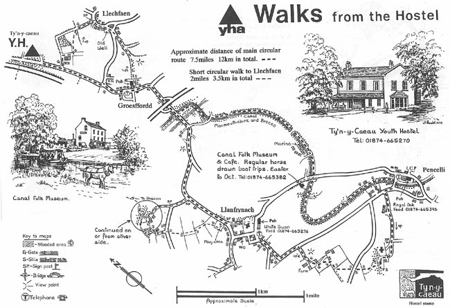
This walk is one of many routes prepared by Martyn Hanks for Youth Hostellers. The routes were drawn in a 'Wainwright' style and provided annotated maps offering additional information for walkers. Prepared before the days of GPS they were an invaluable resource and Walking Britain is happy to ensure that these walks remain in the public domain.
Maps 

| Ordnance Survey Explorer OL12 | Sheet Map | 1:25k | BUY |
| Anquet OS Explorer OL12 | Digital Map | 1:25k | BUY |
| Ordnance Survey Digital Map Subscription | |||
| Latest Ordnance Survey Discounts | |||
Other walks nearby
| Walk 3546 | Pen y Bryn from Pencelli | moderate | 5.0 miles |
| Walk 3536 | Pen y Bryn & Carn Pica from Pencelli | mod/hard | 11.3 miles |
| Walk 3210 | Pen-y-Crug hill fort from Brecon | easy | 3.0 miles |
| Walk 3564 | Groesfford and M & B Canal from Brecon | easy/mod | 6.2 miles |
| Walk 3236 | Pen-y-crug, Sarnau and Battle from Brecon | moderate | 10.0 miles |
| Walk 2400 | Pen y Fan from Cwmgwdi near Brecon | moderate | 5.0 miles |
| Walk 1903 | Pen y Fan & Corn Du from Cwmgwdi | moderate | 7.5 miles |
| Walk 2074 | Highest Peaks of the Brecon Beacons | mod/hard | 11.0 miles |
| Walk 2754 | Allt Lwyd & Waun Rydd | moderate | 7.3 miles |
| Walk 1283 | Fan y Big from Torpantau | moderate | 8.5 miles |
Recommended Books & eBooks
Walking on the Brecon Beacons
 45 circular day walks are described in this guidebook to the Brecon Beacons National Park. From west to east, Mynydd Du, Fforest Fawr, the Brecon Beacons and the Black Mountains these mountain and valley routes offer many options, highlighting the natural features. The walks described explore dramatic waterfalls, wooded gorges and upland valleys.
More information
The Cambrian Way
 Guidebook to the Cambrian Way, a challenging three-week mountain trek through Wales from Cardiff to Conwy. The 470km un-waymarked route is presented from south to north. Often sticking to long, beautiful ridgelines, it crosses wild and rugged terrain and visits many of Wales's highest mountains, including Snowdon.
More information
