Pen y Bryn & Carn Pica from Pencelli
Brecon Beacons/Bannau Brycheiniog Walk
Nat Park - Brecon Beacons - Brecon Beacons Central
County/Area - Powys
Author - Lou Johnson
Length - 11.3 miles / 18.4 km Ascent - 2400 feet / 727 metres
Time - 8 hours 0 minutes Grade - mod/hard
Walk Route Description
Click image to see photo description.
This Brecon Beacons walk starts from the village of Pencelli which can be reached by taking the B4558 south-east from Brecon. The route includes a section of high-level walking taking in the summit of Pen y Bryn before continuing south to Rhiw Bwlch y Ddwyallt. From here the walk heads east to Carn Pica and over Twyn Du before rapidly losing height to join the Taff Trail for relatively easy walking along a disused railway and on the towpath of the Monmouthshire and Brecon Canal back to the start. The terrain crossed can be confusing in low cloud so good navigational skills and a decent map are required for this walk.
The start is the small car park at the west end of Pencelli village (grid ref. SO091250) which is perfectly placed for this walk. After parking exit the car park and turn right (west). Ignore the lane on the left at the first junction and continue for a further 150 metres and take the next lane on the left. A steady climb up the lane for about 1.4 km brings you to a fingerpost on the left-hand side of the lane (grid ref. SO080244). (Note this is the second fingerpost along the lane.)
Turn right off the lane and follow the path between trees through the left-hand metal gate. After 600 metres the path reached open country. Ahead to the south, lies the first objective of this walk, Pen y Bryn. There are several paths once open country is reached. Provided you are heading just west of south and climbing, then you are heading in the right direction. The ground starts to steepen above 500 metres and soon you have reached the summit area with two individual tops with a cairn on the lower of the two (grid ref. SO072227).
This minor summit provides some excellent views across the Usk Valley to the high peaks of the Black Mountains. After regaining your breath leave Pen y Bryn following a clear path south-south-west. The path climbs steadily to reach Rhiw Bwlch y Ddwyallt, with Cwn Cwareli far below on your right. At grid ref. SO057205 you reach a junction of paths at a dramatic location with a deep valley ahead and slightly left and Cwn Cwareli on your right. In poor visibility this is the key point to continuing the walk.
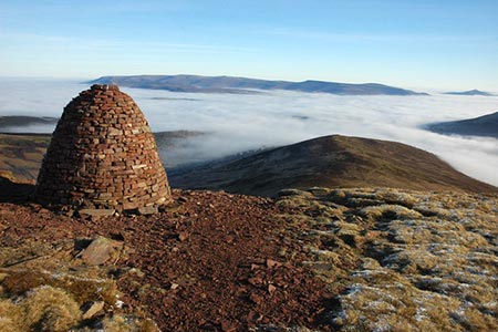
Turn left following a path over Waun Rydd and continue to the recently rebuilt Carn Pica (grid ref. SO069201) perched on top of a steep escarpment. The route ahead follows a path almost due east across Twyn Du. As you progress you soon get a great view down to Talybont Reservoir lying a thousand feet below. Continue along the path which drops quite steeply to leave the Open Access Area (grid ref. SO097206). Join the bridleway to complete the descent into the valley joining a metalled lane at grid ref. SO102208). Continue down this lane to reach the reach the main valley road.
Turn left and cross Aber Bridge. Continue to Aber Farm where you take the signed footpath on the right. Continue across the footbridge to the old railway, where waymarks lead you onto the Taff Trail. Turn left along the Taff Trail and continue to Talybont-on-Usk. From here the Taff Trail follows the towpath of the Monmouthshire and Brecon Canal back to the start at Pencelli. This stretch of canal has some attractive drawbridges that date from when the canal was constructed.
Maps 

| Ordnance Survey Explorer OL12 | Sheet Map | 1:25k | BUY |
| Anquet OS Explorer OL12 | Digital Map | 1:25k | BUY |
| Ordnance Survey Explorer OL13 | Sheet Map | 1:25k | BUY |
| Anquet OS Explorer OL13 | Digital Map | 1:25k | BUY |
| Ordnance Survey Digital Map Subscription | |||
| Latest Ordnance Survey Discounts | |||
Other walks nearby
| Walk 3546 | Pen y Bryn from Pencelli | moderate | 5.0 miles |
| Walk 3209 | Llanfrynach and Pencelli circular | easy/mod | 5.6 miles |
| Walk 2754 | Allt Lwyd & Waun Rydd | moderate | 7.3 miles |
| Walk 3210 | Pen-y-Crug hill fort from Brecon | easy | 3.0 miles |
| Walk 3564 | Groesfford and M & B Canal from Brecon | easy/mod | 6.2 miles |
| Walk 3236 | Pen-y-crug, Sarnau and Battle from Brecon | moderate | 10.0 miles |
| Walk 2400 | Pen y Fan from Cwmgwdi near Brecon | moderate | 5.0 miles |
| Walk 1903 | Pen y Fan & Corn Du from Cwmgwdi | moderate | 7.5 miles |
| Walk 2074 | Highest Peaks of the Brecon Beacons | mod/hard | 11.0 miles |
| Walk 1283 | Fan y Big from Torpantau | moderate | 8.5 miles |
Recommended Books & eBooks
Walking on the Brecon Beacons
 45 circular day walks are described in this guidebook to the Brecon Beacons National Park. From west to east, Mynydd Du, Fforest Fawr, the Brecon Beacons and the Black Mountains these mountain and valley routes offer many options, highlighting the natural features. The walks described explore dramatic waterfalls, wooded gorges and upland valleys.
More information
The Cambrian Way
 Guidebook to the Cambrian Way, a challenging three-week mountain trek through Wales from Cardiff to Conwy. The 470km un-waymarked route is presented from south to north. Often sticking to long, beautiful ridgelines, it crosses wild and rugged terrain and visits many of Wales's highest mountains, including Snowdon.
More information
