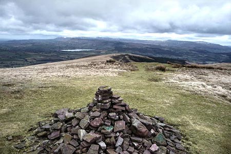
Pen y Bryn from Pencelli
Brecon Beacons/Bannau Brycheiniog Walk
Nat Park - Brecon Beacons - Brecon Beacons Central
County/Area - Powys
Author - Lou Johnson
Length - 5.0 miles / 8.1 km Ascent - 1400 feet / 424 metres
Time - 3 hours 50 minutes Grade - moderate
Walk Route Description
Click image to see photo description.
This short but energetic Brecon Beacons walk starts from the village of Pencelli which lies a few miles south-east of Brecon on the B4558. The objective is the summit of Pen y Bryn (562 metres) which offers extensive views over the Usk Valley and the Black Mountains. There is a small car park at the west end of the village (grid ref. SO091250) which is perfectly placed for this walk.
After parking exit the car park and turn right (west). Ignore the lane on the left at the first junction and continue for a further 150 metres and take the next lane on the left. This lane climbs steadily beaning gently to the right and then left again. Beyond this point (some 1.4 km from the start of the lane) you reach a fingerpost on the left-hand side of the lane (grid ref. SO080244). Note this is the second fingerpost along the lane. Turn right off the lane and follow the path between trees through the left-hand metal gate. After 600 metres the path reached open country.
Ahead to the south, lies the objective of this walk, Pen y Bryn. There are a number of paths once open country is reached. Provided you are heading just west of south and climbing, then you are heading in the right direction. The ground starts to steepen above 500 metres and soon you have reached the summit area with two individual tops with a cairn on the lower of the two (grid ref. SO072227).
On a fine day the summit is a fine place to enjoy the views especially to the north across the Usk Valley to the high peaks of the Black Mountains. All that remains is to retrace your steps downhill to the lane and back to the start.
Maps 

| Ordnance Survey Explorer OL12 | Sheet Map | 1:25k | BUY |
| Anquet OS Explorer OL12 | Digital Map | 1:25k | BUY |
| Ordnance Survey Digital Map Subscription | |||
| Latest Ordnance Survey Discounts | |||
Other walks nearby
| Walk 3536 | Pen y Bryn & Carn Pica from Pencelli | mod/hard | 11.3 miles |
| Walk 3209 | Llanfrynach and Pencelli circular | easy/mod | 5.6 miles |
| Walk 2754 | Allt Lwyd & Waun Rydd | moderate | 7.3 miles |
| Walk 3210 | Pen-y-Crug hill fort from Brecon | easy | 3.0 miles |
| Walk 3564 | Groesfford and M & B Canal from Brecon | easy/mod | 6.2 miles |
| Walk 3236 | Pen-y-crug, Sarnau and Battle from Brecon | moderate | 10.0 miles |
| Walk 2400 | Pen y Fan from Cwmgwdi near Brecon | moderate | 5.0 miles |
| Walk 1903 | Pen y Fan & Corn Du from Cwmgwdi | moderate | 7.5 miles |
| Walk 2074 | Highest Peaks of the Brecon Beacons | mod/hard | 11.0 miles |
| Walk 1283 | Fan y Big from Torpantau | moderate | 8.5 miles |
Recommended Books & eBooks
Walking on the Brecon Beacons
 45 circular day walks are described in this guidebook to the Brecon Beacons National Park. From west to east, Mynydd Du, Fforest Fawr, the Brecon Beacons and the Black Mountains these mountain and valley routes offer many options, highlighting the natural features. The walks described explore dramatic waterfalls, wooded gorges and upland valleys.
More information
The Cambrian Way
 Guidebook to the Cambrian Way, a challenging three-week mountain trek through Wales from Cardiff to Conwy. The 470km un-waymarked route is presented from south to north. Often sticking to long, beautiful ridgelines, it crosses wild and rugged terrain and visits many of Wales's highest mountains, including Snowdon.
More information
