Port Quin & Port Isaac Circular
Cornwall AONB Walk
Region - Cornwall AONB
County/Area - Cornwall
Author - Lou Johnson
Length - 5.7 miles / 9.3 km Ascent - 900 feet / 273 metres
Time - 3 hours 50 minutes Grade - easy/mod
Walk Route Description
Click image to see photo description.
This circular walk from Port Quin to Port Isaac offers a taste of the north Cornwall coast and countryside. The outward route follows an inland path. After exploring Port Isaac with its wide range of amenities, the return route follows the South West Coast Path along a lovely section of coast back to the start.
The start is the small National Trust car park at Port Quin (grid ref. SW972805). After parking exit the car park and turn right up the lane and continue to the first footpath sign on the left (Port Isaac - inland route). Continue in front of cottage and keep straight ahead to follow a well-trodden path with hedge on your right. Reaching the second field keep ahead on the path to join a clear track. Follow this track for about a kilometre to where the track turns sharp right towards Roscarrock Farm (grid ref. SW988805). At this point turn left (hedge on left) and follow the path which soon descends to a footbridge in a valley.
Cross the footbridge and turn left. Immediately bear half right up the hillside. Continue to a stile in the hedge (grid ref. SW992807). Continue along the left side of the field along a clear path. The path soon leads you through a gate to join a road (Roscarrock Hill). Descend the lane into the centre of Port Isaac (grid ref. SW 996807).
To explore Port Isaac, continue ahead past the Lifeboat Station on your right. Continue up narrow Fore Street to turn right into Back Hill (opposite the Old School). A steady climb up Back Hill leads you into to New Road. Descend to the sea front. Turn left into New Road long-stay car park and pick up the path along the cliff tops (grid ref. SX00810). You are now on the South West Coast Path.
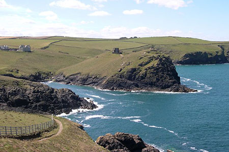
Follow the SWCP around the headland (sea on your right). The path will lead you back into Fore Street. Continue down to pass the Lifeboat Station (now on your left) and bear right up Roscarrock Hill. At the end of this road Turn right to join the SWCP, which is followed back to Port Quin. It is a lovely section of coast. The first objection is Lobber Point after which you descend to a footbridge at Pine Haven. An ascent to Varley Head is soon followed by a view along Reedy Cliff to Kellan Head. After Kellan Head the path turns south and returns to Port Quin. It is worth noting that the path is easy to follow although there are some sections of steps.
Maps 

| Ordnance Survey Explorer 106 | Sheet Map | 1:25k | BUY |
| Anquet OS Explorer 106 | Digital Map | 1:25k | BUY |
| Ordnance Survey Digital Map Subscription | |||
| Latest Ordnance Survey Discounts | |||
Other walks nearby
| Walk 2462 | The Rumps & Pentire Point | easy/mod | 4.0 miles |
| Walk 3738 | Polzeath & Pentire Point from Rock | moderate | 11.4 miles |
| Walk 3589 | Padstow from Little Petherick | easy | 5.0 miles |
| Walk 1029 | Tintagel to Boscastle | moderate | 9.0 miles |
| Walk 1547 | Trevose Head & Constantine Bay from Porthcothan | easy/mod | 8.5 miles |
| Walk 1961 | Porthcothan to Watergate Bay | easy/mod | 6.8 miles |
| Walk 1883 | Advent Church | easy | 5.2 miles |
| Walk 1808 | Brown Willy, exploring Cornwall's highest Tors | easy/mod | 4.0 miles |
| Walk 3279 | Tors of Bodmin Moor | moderate | 10.0 miles |
| Walk 2730 | St Gennys & Castle Point from Crackington Haven | easy/mod | 3.0 miles |
Recommended Books & eBooks
The South West Coast Path
 Guidebook to walking the entire South West Coast Path National Trail. The route runs for 630 miles from Minehead to Poole along the north Devon, Cornish, south Devon and Dorset coastline. Divided into 45 stages, this long-distance coastal trek could be completed within 4 weeks, or walked in sections. Guide includes maps and essential information.
More information
South West Coast Path Map Booklet - St Ives to Plymouth
 Map of part of the southern section of the 630 mile (1014km) South West Coast Path National Trail. Covers the trail from St Ives to Plymouth along the west Cornwall and Devon coastline. This convenient and compact booklet of Ordnance Survey 1:25,000 maps shows the route, providing all of the mapping you need to walk the trail in either direction.
More information
