St Gennys & Castle Point from Crackington Haven
Cornwall Walk
County/Area - Cornwall
Author - Lou Johnson
Length - 3.0 miles / 4.9 km Ascent - 900 feet / 273 metres
Time - 2 hours 20 minutes Grade - easy/mod
Walk Route Description
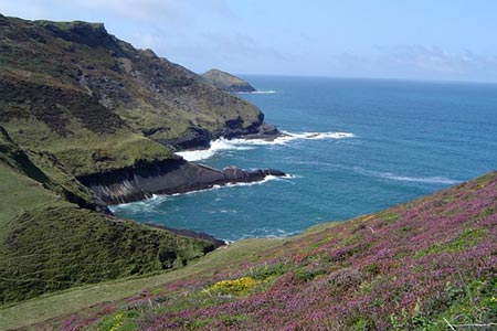
Click image to see photo description.
The delightful Cornish village of Crackington Haven lies on a dramatic section of coast with the high cliffs formed from contorted rock formations. This walk visits the hamlet of St Gennys, with its attractive church, before continuing north to join the South West Coast Path National Trail. The route then continues along the Coast Path to Castle Point and Pencannow Point before descending back to the village. The walk uses well signed paths and is an energetic outing with plenty of uphill walking.
The start is the pay and display car park in Crackington Haven (grid ref. SX143968). In fine weather and during holiday periods space maybe at a premium so an early or late start is recommended. After parking, exit the car park towards the sea. Turn right along the lane passing the Coombe Barton Inn. Walk uphill along the lane for about 800 metres to the first road junction (grid ref. SX151967). Care is needed on this section with traffic on the narrow lane. Turn sharp left up a track that climbs steeply between hedges. Reaching a T-junction, turn left. You now can enjoy some wonderful north along the coast.
Continue along this lane towards St Gennys. The church rower soon comes into view as you reach a road junction (grid ref. SX149970). Continue straight ahead to the village centre and visit the Church. With your back to the church, turn left back the way you came. Walk past the small parking area on the left and take the narrow lane immediately after on your left. Continue along this lane which leads to St Gennys House. Do not enter the private drive and take footpath on the left through a kissing gate. Follow this path down across a footbridge to climb up to the South West Coast Path (grid ref. SX150976).
Turn left along the Coast Path soon reaching Castle Point. Another descent leads you down to cross a stream before the path zigzags up to gain the high ground once more. Continue along the Coast Path to reach Pencannow Point where it is worth walking along the spur path to enjoy the view. From here the Coast Path descends back down to Crackington Haven. Reaching the road, turn right and you will back at the start in a few minutes.
If you have the time and energy, you can continue to Walk 2731 and explore the coastal scenery to the south of Crackington Haven.
Maps 

| Ordnance Survey Explorer 111 | Sheet Map | 1:25k | BUY |
| Anquet OS Explorer 111 | Digital Map | 1:25k | BUY |
| Ordnance Survey Digital Map Subscription | |||
| Latest Ordnance Survey Discounts | |||
Other walks nearby
| Walk 1076 | Dizzard Point & Crackington Haven | moderate | 8.0 miles |
| Walk 3755 | Dizzard Point, Millook from Penhalt Cliff | moderate | 6.0 miles |
| Walk 1029 | Tintagel to Boscastle | moderate | 9.0 miles |
| Walk 1808 | Brown Willy, exploring Cornwall's highest Tors | easy/mod | 4.0 miles |
| Walk 3279 | Tors of Bodmin Moor | moderate | 10.0 miles |
| Walk 1996 | Woodford & Hollygrove Wood | easy/mod | 5.1 miles |
| Walk 1883 | Advent Church | easy | 5.2 miles |
| Walk 3207 | Knap Head to Mansley Cliff | moderate | 8.0 miles |
| Walk 1788 | Welcombe Mouth and Darracott | moderate | 6.0 miles |
| Walk 3264 | Port Quin & Port Isaac Circular | easy/mod | 5.7 miles |
Recommended Books & eBooks
Walking in Cornwall
 This guidebook includes routes to 40 day walks in Cornwall. From short, easy strolls to longer, wilder routes, there is plenty to appeal to both families and experienced walkers. The walks explore the interior and coasts, including walks through picturesque villages, old tin-mining areas and the Lizard and Land's End Peninsulas.
More information
South West Coast Path Map Booklet - St Ives to Plymouth
 Map of part of the southern section of the 630 mile (1014km) South West Coast Path National Trail. Covers the trail from St Ives to Plymouth along the west Cornwall and Devon coastline. This convenient and compact booklet of Ordnance Survey 1:25,000 maps shows the route, providing all of the mapping you need to walk the trail in either direction.
More information
