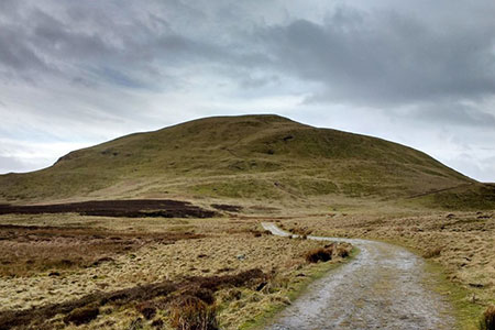
West Lomond from Craigmead
Fife Walk
County/Area - Fife
Author - Lou Johnson
Length - 5.0 miles / 8.1 km Ascent - 740 feet / 224 metres
Time - 3 hours 10 minutes Grade - easy/mod
Walk Route Description
Click image to see photo description.
This walk to the summit of West Lomond (Fife) takes you to the highest point in the Lomond Hills and Fife. West Lomond has volcanic origins and its conical outline is a prominent feature in the landscape. The route follows well-used paths and your efforts are rewarded with extensive views east across the Lomond Hills and west over Loch Leven. For most of the route your objective is in sight, a rocky cone rising above the moorland.
The walk starts from Craigmead car park (grid ref. NO227062) which is located a few miles south-west of Falkland. The route starts from the right had rear corner of the car park to the left of the public toilets. Follow the clear path through the trees and turn left across grass soon following a wall on your right. At the corner of the field go through the gap and join a wider path with a wall on your right.
The clear path/track continues across moorland to reach another wall. Continue alongside the wall for a short distance and then cross Forthear Burn. After passing through a gap in a wall, the path continues over rising ground heading for the lower slopes of the north flank of West Lomond. The path then loops around to the left gaining height to reach the summit of the hill with its OS trig column marking the highest point.
After enjoying the view retrace your outward route back to the start. One point to note is that in descent ensure you take the right-hand path where the track continues between walls (grid ref. NO222064). If time and energy permit, you can continue to the summit of East Lomond which is in view for much of this walk - go to East Lond from Craigmead walk.
Maps 

| Ordnance Survey Explorer 370 | Sheet Map | 1:25k | BUY |
| Anquet OS Explorer 370 | Digital Map | 1:25k | BUY |
| Ordnance Survey Digital Map Subscription | |||
| Latest Ordnance Survey Discounts | |||
Other walks nearby
| Walk 3280 | West Lomond from near Gateside | moderate | 6.8 miles |
| Walk 1962 | Lower Largo to Elie - Fife Coastal Path | easy/mod | 7.4 miles |
| Walk 1562 | Elie to Pittenweem - Fife Coastal Path | easy | 6.0 miles |
| Walk 1558 | Out Head & West Sands, St Andrews | easy | 3.0 miles |
| Walk 1979 | Culross Heritage | easy | 1.5 miles |
| Walk 1563 | Pittenweem to Crail - Fife Coastal Path | easy | 4.5 miles |
| Walk 1700 | Edinburgh - Royal Mile, Arthur's Seat & Princes Street | easy | 5.5 miles |
| Walk 1803 | Edinburgh - Salisbury Crags and the Royal Mile | easy | 4.0 miles |
| Walk 2061 | Edinburgh - Calton Hill and the city centre | easy | 3.0 miles |
| Walk 2222 | Ben Cleuch from Tillicoultry | moderate | 7.0 miles |
