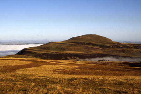
West Lomond from near Gateside
Fife Walk
County/Area - Fife
Author - Lou Johnson
Length - 6.8 miles / 11.1 km Ascent - 1350 feet / 409 metres
Time - 4 hours 50 minutes Grade - moderate
Walk Route Description
Click image to see photo description.
This West Lomond walk takes an interesting approach from the west side of the Lomond Hills (Fife). The route includes the Bonnet Stone, the summit of West Lomond and a descent through Glen Vale. The walk follows generally clear paths and offers superb views east across the Lomond Hills and west over Loch Leven.
The start is the small roadside Bunnet Stone parking area (grid ref. NO185082) on a minor road south-east from Gateside. After parking go through the metal gate onto a clear track with stone wall on your left. When the track ends continue on the footpath, again keeping the wall to your left. Cross three fields to enter a field containing the Bonnet Stone (grid ref. NO190071), which is topped by a mushroom shaped rock.
From the stone, head half left up the top left-hand corner of the field. Continue up this field and after 120 metres turn left and follow the field boundary up to another stile (grid ref. NO193070). The onward path then curves uphill along a grassy ledge to reach and area of flatter ground. Continue along the path to reach a wide path. Turn right and follow the clear path as it curved around the hill to reach the summit of West Lomond (grid ref. NO197066) with its trig column and cairn.
After enjoying the extensive view retrace your steps by descending the main path. You soon reach the point where you meet the Bunnet Stone path. Continue along the main path for about 50 metres and turn right onto a less distinct path heading south. Reaching a cross path (grid ref. approx. NO200064), bear left and follow this path down to a stile (grid ref. NO202061). The path continues south with fence on right before crossing fence to continue downhill with fence left. Reaching a clear track (grid ref. NO201055) turn right and follow the track down the valley for 700 metres to just after left a bend (grid ref. NO194056).
At this point leave the track by taking the footpath on the right. The path descends through Glen Vale passing Glen Vale Waterfalls. The path stays north of Glen Burn to join a clear track (grid ref. NO186061). Not shown on OS maps this track, on the north side of Glen Burn, leads to the road. Turn right along the road to pass an alternative car park (grid ref. NO172069). Continue along the road for a 1.5 kilometre walk back to the start.
Maps 

| Ordnance Survey Explorer 370 | Sheet Map | 1:25k | BUY |
| Anquet OS Explorer 370 | Digital Map | 1:25k | BUY |
| Ordnance Survey Digital Map Subscription | |||
| Latest Ordnance Survey Discounts | |||
Other walks nearby
| Walk 3281 | East Lomond from Craigmead | easy | 2.5 miles |
| Walk 3282 | West Lomond from Craigmead | easy/mod | 5.0 miles |
| Walk 1962 | Lower Largo to Elie - Fife Coastal Path | easy/mod | 7.4 miles |
| Walk 2222 | Ben Cleuch from Tillicoultry | moderate | 7.0 miles |
| Walk 1979 | Culross Heritage | easy | 1.5 miles |
| Walk 1562 | Elie to Pittenweem - Fife Coastal Path | easy | 6.0 miles |
| Walk 1558 | Out Head & West Sands, St Andrews | easy | 3.0 miles |
| Walk 1700 | Edinburgh - Royal Mile, Arthur's Seat & Princes Street | easy | 5.5 miles |
| Walk 1803 | Edinburgh - Salisbury Crags and the Royal Mile | easy | 4.0 miles |
| Walk 2061 | Edinburgh - Calton Hill and the city centre | easy | 3.0 miles |
