The Roman Camp at Chew Green
Northumberland Walk
Nat Park - Northumberland
County/Area - Northumberland County & Scottish Borders
Author - Lou Johnson
Length - 5.8 miles / 9.4 km Ascent - 800 feet / 242 metres
Time - 3 hours 40 minutes Grade - easy/mod
Walk Route Description
Click image to see photo description.
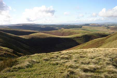
The Cheviot hills are amongst the wildest parts of England with only limited access by road to this part of the Northumberland National Park. This walk includes the Roman Camp at Chew Green and the Roman Signal Station a short distance to the north. The start is the small car park at Chew Green (grid ref. NT794085) at the head of Upper Coquetdale. The journey into the start provides a taste of the scenery to be enjoyed during the walk. From Rothbury take the B6341 through Thropton and after 2 miles take the minor road to Alwinton. From here follow the 'no through road' up Upper Coquetdale for just over 10 miles to Chew Green.
After parking walk west towards the Roman Camp at Chew Green to pick up the Pennine Way at grid ref. NT791084. Turn right onto the Pennine Way with the remains of the Roman Camp on your left. Continue north following the Pennine Way until your reach the border fence (grid ref. NT790095). A short diversion across the fence into Scotland will allow you explore the remains of the old Roman Signal Station which occupies a position with a wide ranging view across the border into Scotland.
Leave the Pennine Way at this point and take the path initially heading NE but soon swinging ENE to the Dodd. In approximately 600 metres from the border fence you join a bridleway heading towards Deel's Hill. The onward route follows a similar heading and descends across wild country to the road Buckham's Bridge (grid ref. NT824107). Turn right along the road back to Chew green and the parking area.
Maps 

| Ordnance Survey Explorer OL16 | Sheet Map | 1:25k | BUY |
| Anquet OS Explorer OL16 | Digital Map | 1:25k | BUY |
| Ordnance Survey Digital Map Subscription | |||
| Latest Ordnance Survey Discounts | |||
Other walks nearby
| Walk 2169 | Chew Green & Upper Coquet Valley | easy/mod | 5.8 miles |
| Walk 2251 | Yearning Saddle & Brownhart Law | moderate | 7.8 miles |
| Walk 1200 | Windy Gyle | moderate | 7.5 miles |
| Walk 1763 | Mozie Law & Windy Gyle | moderate | 8.2 miles |
| Walk 3085 | The Dodd & Wether Cairn | moderate | 9.5 miles |
| Walk 2299 | The Cheviot | moderate | 9.0 miles |
| Walk 3296 | Grubbit Law & Hownam Law from Morebattle | moderate | 7.0 miles |
| Walk 2163 | Darden Pike & Darden Lough | easy/mod | 4.2 miles |
| Walk 1766 | Cushat Law and Bloodybush Edge from Hartside | mod/hard | 12.5 miles |
| Walk 1201 | Black Hag from Kirk Yetholm | moderate | 8.5 miles |
Recommended Books & eBooks
The Pennine Way - the Path, the People, the Journey
 A portrait of the The Pennine Way, Britain's oldest and best known long-distance footpath, stretching 268 miles from the Peak District to the Scottish Borders. This personal, thoughtful and often humorous story of the path's remarkable history, includes the experiences of walkers and local characters on this exhilarating and complex path.
More information
The Pennine Way
 Guidebook to the Pennine Way National Trail with OS map booklet. The 265 mile route from Edale to Kirk Yetholm takes three weeks to walk and is suitable for fit and experienced long distance walkers. The route crosses the Peak District, Yorkshire Dales and North Pennines National Parks. Includes separate OS 1:25,000 map booklet of the route.
More information
