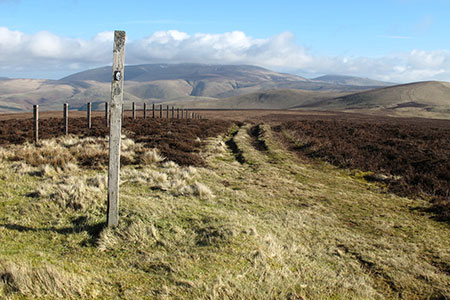
Mozie Law & Windy Gyle from Coquet Valley
Northumberland Walk
Nat Park - Northumberland
County/Area - Northumberland County & Scottish Borders
Author - Lou Johnson
Length - 8.2 miles / 13.3 km Ascent - 1600 feet / 485 metres
Time - 5 hours 40 minutes Grade - moderate
Walk Route Description
Click image to see photo description.
An undulating walk in the Northumberland National Park exploring two hills that straddle the England-Scotland border. The first half of the route follows paths and tracks including a section of the Pennine Way along the border fence. The descent from Windy Gyle follows a grassy path back into the valley.
The start is in the upper Coquet Valley on a minor road a kilometre northwest of Barrowburn where there is a small parking area by a bridge (grid ref. NT859114). The pleasant drive up the valley gives a good impression of the terrain to be encountered during the walk. After parking cross the bridge and take the stile on the right. Head up the clear grassy track with the fence on your left. Continue uphill to the next stile from where the fence is on your right. The grassy track climbs steadily passing across the eastern flank of Swineside Law.
Descend to a grassy col, cross the stile, and continue up the grassy track. Nearing the top of the climb cross another stile and follow the track to reach Plea Know (grid ref. NT835150) with a four-way fingerpost. Turn left over a stile to join the Pennine Way (signed Mozie Law). The grassy path soon becomes paved and follows the fence on your right which leads you to the summit of Mozie Law. Cross the fence (England/Scotland border) to reach the true summit which is in Scotland.
Retrace your steps back top Plea Know. Turn left to follow the Pennine Way in an easterly direction to the summit of Windy Gyle (619 m.) with large cairn topped with an OS trig column. To descend follow the signed path to the Coquet Valley. After leaving the summit the path initially heads south to join a grassy track trending south-east. Follow this track for 350 metres noting that it bears half right to head south (grid ref. NT860148). The path fades in places but makes a gentle descent through Rowhope back to the start.
Maps 

| Ordnance Survey Explorer OL16 | Sheet Map | 1:25k | BUY |
| Anquet OS Explorer OL16 | Digital Map | 1:25k | BUY |
| Ordnance Survey Digital Map Subscription | |||
| Latest Ordnance Survey Discounts | |||
Other walks nearby
| Walk 2169 | Chew Green & Upper Coquet Valley | easy/mod | 5.8 miles |
| Walk 2251 | Yearning Saddle & Brownhart Law | moderate | 7.8 miles |
| Walk 3353 | The Roman Camp at Chew Green | easy/mod | 5.8 miles |
| Walk 3085 | The Dodd & Wether Cairn | moderate | 9.5 miles |
| Walk 2299 | The Cheviot | moderate | 9.0 miles |
| Walk 1766 | Cushat Law and Bloodybush Edge from Hartside | mod/hard | 12.5 miles |
| Walk 1764 | The Cheviot from Langleeford | mod/hard | 8.2 miles |
| Walk 1765 | Comb Fell & Hedgehope Hill from Langleeford | mod/hard | 8.9 miles |
| Walk 1776 | The Cheviot & Auchope Cairn from Langleeford | mod/hard | 10.0 miles |
| Walk 2152 | Hartshope Linn (waterfall) from Langleeford | easy | 4.4 miles |
Recommended Books & eBooks
Pennine Way Map Booklet
 Map of the 270 miles (435km) Pennine Way National Trail, between Edale in the Peak District and Kirk Yetholm in the Scottish Borders. This booklet is included with the Cicerone guidebook to the trail, and shows the full route on Ordnance Survey 1:25,000 maps. This popular long-distance route typically takes three weeks to complete.
More information
The Pennine Way - the Path, the People, the Journey
 A portrait of the The Pennine Way, Britain's oldest and best known long-distance footpath, stretching 268 miles from the Peak District to the Scottish Borders. This personal, thoughtful and often humorous story of the path's remarkable history, includes the experiences of walkers and local characters on this exhilarating and complex path.
More information
