Yearning Saddle & Brownhart Law
Northumberland Walk
Nat Park - Northumberland
County/Area - Northumberland County
Author - Lou Johnson
Length - 7.8 miles / 12.7 km Ascent - 950 feet / 288 metres
Time - 4 hours 50 minutes Grade - moderate
Walk Route Description
Click image to see photo description.
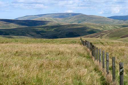
Starting from Buckham's Bridge in Upper Coquetdale, this walk explores an area of hills and moorland close to the Scottish border. The route includes a section of the Pennine Way. The area is remote and wild, providing a taste of this beautiful landscape. After initially following Blind Burn into the hills, the route reaches the Pennine Way. Turning south the walk offers excellent views of the sea of hills across the border fence in Scotland. From the Roman Signal Station by Brownhart Law, the walk crosses the flank of Deel's Hill to descend to the start.
Th walk starts from the small car park at Buckham's Bridge (grid ref. NT824107), which lies about 10 miles up the Coquet Valley from Alwinton. After parking, walk down to the group of houses at Blindburn. Just before the bridge turn left onto the signed footpath through a wooden gate. The path crosses a field, to a small bridge over the Blind Burn and then continues up stream with the Burn on your left. Over to your left rises Yearning Law. Cross a stream coming down on the right (grid ref. NT820124) and then start to climb soon passing the ruins of Yearning Hall.
After 600 metres you pass between ancient circular enclosures. Head northwest on a grassy path to reach a more distinct grassy track. Bear left and continue to the Mountain Refuge Hut on the Pennine Way at Yearning Saddle (grid ref. NT804129). The view into Scotland is superb. Turn left along the Pennine Way and cross wild moorland (with no views). The path is generally clear on the ground with occasional way posts. As you approach the Roman Signal Station with Brownhart Law rising ahead, the path briefly enters Scotland although there are no signs to indicate this.
Reaching a gate (grid ref. NT791096), do not pass through the gate but leave the Pennine Way and turn left. Using the fence on your right as a guide, continue slightly downhill to reach The Dodd. Maintain direction towards Deel's Hill ahead from where a grassy track provides a descent down the hill's eastern ridge to return to the car park at Buckham's Bridge. This section offers a fine view into Upper Coquetdale and across the surrounding hills.
Maps 

| Ordnance Survey Explorer OL16 | Sheet Map | 1:25k | BUY |
| Anquet OS Explorer OL16 | Digital Map | 1:25k | BUY |
| Ordnance Survey Digital Map Subscription | |||
| Latest Ordnance Survey Discounts | |||
Other walks nearby
| Walk 1200 | Windy Gyle | moderate | 7.5 miles |
| Walk 1763 | Mozie Law & Windy Gyle | moderate | 8.2 miles |
| Walk 3353 | The Roman Camp at Chew Green | easy/mod | 5.8 miles |
| Walk 3085 | The Dodd & Wether Cairn | moderate | 9.5 miles |
| Walk 2299 | The Cheviot | moderate | 9.0 miles |
| Walk 3296 | Grubbit Law & Hownam Law from Morebattle | moderate | 7.0 miles |
| Walk 1766 | Cushat Law and Bloodybush Edge from Hartside | mod/hard | 12.5 miles |
| Walk 1764 | The Cheviot from Langleeford | mod/hard | 8.2 miles |
| Walk 1765 | Comb Fell & Hedgehope Hill from Langleeford | mod/hard | 8.9 miles |
| Walk 1776 | The Cheviot & Auchope Cairn from Langleeford | mod/hard | 10.0 miles |
Recommended Books & eBooks
Pennine Way Map Booklet
 Map of the 270 miles (435km) Pennine Way National Trail, between Edale in the Peak District and Kirk Yetholm in the Scottish Borders. This booklet is included with the Cicerone guidebook to the trail, and shows the full route on Ordnance Survey 1:25,000 maps. This popular long-distance route typically takes three weeks to complete.
More information
Walking in Northumberland
 This guidebook contains detailed route descriptions for 36 day walks in Northumberland including the Cheviot Hills. The terrain varies from wild walks and craggy ascents to gentle riverside strolls. Each route ranges from 4 to 16 miles in length and there is the opportunity to link several walks together to create longer treks.
More information
