Rollgate Bank & Aumery Park from Fadmoor
North York Moors Walk
Nat Park - North York Moors - North York Moors West
County/Area - North Yorkshire
Author - Andy Chaplin
Length - 11.0 miles / 17.9 km Ascent - 1000 feet / 303 metres
Time - 6 hours 30 minutes Grade - moderate
Walk Route Description
Click image to visit gallery of 3 images.
This North York Moors walk takes in the Hodge Beck valley as it comes through Sleightholme Dale. From Aldergate and Rollgate Banks you get views eastwards into the Hodge Beck valley and northwards towards Pockley Moor. The starting point, Fadmoor, is some 3km north west of Kirkbymoorside and is a pleasant village where many of the farms and houses surround the village green. There is a village farm shop, room to park around the village green "triangle" but unfortunately the village pub has closed.
The walk starts at grid ref. SE675893 and heads south on Onams Lane then right onto Starfits Lane. After 150m take the footpath off on the right which goes alongside the fence on the left and comes out onto Sleightholme Dale Road where you get the first impression, hidden largely by the trees, of the Hodge Beck valley. Turn left on Sleightholme Dale road then take the track straight ahead at the junction - this is Caldron Mill Road (part of the Tabular Hills Walk - THW). After 300m turn off right on the bridleway through Mell Bank Wood and after another 300m keep right at the path junction to go down to the beck.
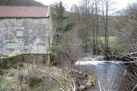
Follow the track then path along the east side of the beck under Brockhill Hagg until you come to the mill buildings at Hold Caldron. Cross over the beck then take the THW up the far bank, along the side of the woods and then out onto Skiplam Road. Follow the road for 2 miles to Wether Cote Farm then continue along the track along the top of Aldergate Bank then Rollgate Bank. There are great views down into the Hodge Beck valley. Shortly after passing the trig point at SE634907 a track joins from the left then the track heads downhill on the Little Roll gate track. It is helpfully signed as unsuitable for cars and motorcycles at this point.
When you get to the bottom of the bank, pass through one gate then turn almost back on yourself before the second gate to follow an ill-defined path that follows a small stream then keeps close to the northern boundary fence of Otterhill Common. Keep to the northwest of the strip of wood just south of the pond on the Great Runnell stream and when you come to the junction of tracks at SE642915 take the track north then southeast to come to the buildings at Otterhills.
From here you follow the road over the Hodge Beck, through Pennyholme, across the Rudland Beck and the Stonely Woods Beck until you come out of the Pennyholme estate at Cherry Tree Farm. Continue along Sleightholme Dale road until you get to the cottages at Aumery Park then take the path off left through the Intake Plantation. It is signed as part of the Inn Way and the path then continues across the fields back to Fadmoor.
Maps 

| Ordnance Survey Explorer OL26 | Sheet Map | 1:25k | BUY |
| Anquet OS Explorer OL26 | Digital Map | 1:25k | BUY |
| Ordnance Survey Digital Map Subscription | |||
| Latest Ordnance Survey Discounts | |||
Other walks nearby
| Walk 2029 | Lastingham & Rosedale from Hutton-le-Hole | moderate | 12.0 miles |
| Walk 2760 | Riccal Dale & Howl Dale | moderate | 8.2 miles |
| Walk 1920 | Rievaulx Moor from Cowhouse Bank | moderate | 9.5 miles |
| Walk 1542 | The Rudland Ridge from Ousegill Bridge | moderate | 10.1 miles |
| Walk 1921 | Spaunton Moor from Chimney Bank | easy/mod | 8.1 miles |
| Walk 1525 | Beck Dale & Rievaulx from Helmsley | moderate | 9.8 miles |
| Walk 1527 | Farndale Circular from Little Blakey | moderate | 12.0 miles |
| Walk 1674 | Rosedale Valley circular from Little Blakey | moderate | 11.0 miles |
| Walk 2665 | Cawthorne Roman Camp Circular | moderate | 12.2 miles |
| Walk 1704 | Oswaldkirk, Nunnington & Harome circular | moderate | 11.5 miles |
Recommended Books & eBooks
Trail and Fell Running in the Yorkshire Dales
 Guidebook to 40 of the best trail and fell runs in the Yorkshire Dales National Park. Ranging from 5 to 24 miles, the graded runs start from bases such as Ribblehead, Dent, Sedbergh, Malham and Grassington and take in the region's diverse delights, from castles and waterfalls to iconic mountains such as Whernside, Ingleborough and Pen Y Ghent.
More information
