Blencathra via Foule Crag from Scales
Lake District Walk
Nat Park - Lake District - Lake District Northern Fells
Wainwrights - Blencathra
County/Area - Cumbria
Author - Lou Johnson
Length - 8.0 miles / 13 km Ascent - 2900 feet / 879 metres
Time - 6 hours 50 minutes Grade - mod/hard
Walk Route Description
Click image to visit gallery of 12 images.
Blencathra is an iconic mountain dominating the scene on the approach to Keswick along the A66 from Penrith. There are many interesting routes to the summit and the Lake District walk described here approaches from the east using quieter paths for much of the way. The route described is not technically difficult and allows you to see many of the interesting features of Blencathra and the great expansive views that can be enjoyed from the summit.
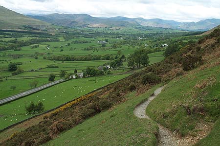
The walk starts from near Scales Farm. Park in one of the lay-bys on the A66 - on a good day spaces may be hard to find! - to take the short footpath (Grid ref NY340267) that provides access beyond the intake wall and onto the fell. After breaching the wall turn right and begin to climb almost immediately with the intake wall on your right. In recent years there have been some path diversions and realignments so maps may not always be too accurate. At grid ref. NY344273 the path leaves the wall and turns north. Follow the path past some crags ignoring paths turning right and left off the main path. Once past the crags, marked as Level (dis) on OS maps, the gradient begins to ease and you reach a broad grassy col between Scales Fell and Souther Fell.
There are a number of paths in this area and you need to take the clear path that heads north-west across the eastern flank of Scales Fell. This gains height steadily offering views ahead to Sharp Edge. Reaching a junction of paths (Grid ref. NY333282), take the right fork and continue along the valley side path. The climb is never steep and quite soon you arrive at the col between Bannedrale Crags and Blencathra (Grid ref. NY327291). The hard work starts now. Turn left and climb the steep mainly grass slope to the summit of Foule Crag. This vantage point offers a birds eye view of Sharp Edge and Scale Tarn far below. It is a perfect place to rest and you can watch the walkers dealing with the challenges of Sharp Edge.
To continue, walk south across the "saddle" of Blencathra to the Halls Fell summit (the highest point on the mountain), which is marked by a trig point. The view from here south across the Lake District is superb and you will enjoy variants of this view for the next mile of so of the walk. Often ignored is the panorama to the north, which includes many of the less well-known fells at the Back o'Skiddaw. Following the main undulating path along the edge with the drop on your left, you will eventually reach Knowe Crags (Grid ref. NY311270).
A long descent now follows with the main path heading southwest. Lookout for a path junction at grid ref. NY306260 where you turn sharp left. The path descends, quite steeply in places to reach the intake wall (Grid ref. NY313259). A well blazed path leads through a walled field to cross Gate Gill (Grid ref. NY324262). From here the onward route follows the intake wall, keeping it on your right. Apart from the need for a little scrambling near Scaley Beck (Grid ref. NY336268) you should encounter no problems reaching the short footpath back to the A66 before Scales Farm.
Maps 

| Ordnance Survey Explorer OL5 | Sheet Map | 1:25k | BUY |
| Anquet OS Explorer OL5 | Digital Map | 1:25k | BUY |
| Ordnance Survey Digital Map Subscription | |||
| Latest Ordnance Survey Discounts | |||
Other walks nearby
| Walk 1354 | Bannerdale Crags & Souther Fell | moderate | 7.5 miles |
| Walk 1073 | Skiddaw & Glenderaterra Beck | moderate | 9.0 miles |
| Walk 1244 | Lonscale Fell & Latrigg | moderate | 7.5 miles |
| Walk 2364 | Clough Head via Great Dodd from near Dockray | moderate | 8.1 miles |
| Walk 1101 | Carrock Fell, High Pike and Knott | moderate | 11.0 miles |
| Walk 1214 | Carrock Fell & High Pike from Mosedale | moderate | 7.0 miles |
| Walk 2587 | Castlerigg Stone Circle & St John's in the Vale | easy/mod | 8.5 miles |
| Walk 1158 | High Rigg | easy | 5.5 miles |
| Walk 2005 | High Rigg & Legburthwaite | easy | 5.5 miles |
| Walk 2049 | Calfhow Pike & the Dodds from Legburthwaite | moderate | 7.5 miles |
Recommended Books & eBooks
Great Mountain Days in the Lake District
 An inspirational guidebook to 50 challenging walks on the high fells of the Lake District. The graded circular routes, between 4 and 14 miles in length, cover classic Lakeland summits like Fairfield, Scafell Pike, Great Gable and Blencathra, to the lesser-known High Spy, King's How and Brund Fell.
More information
Hadrian's Wall Path
 Hadrians Wall Path guidebook to walk the 84 mile National Trail. Described in both directions, the main description is west to east between Bowness-on-Solway and Wallsend, Newcastle, with extensions to Maryport and South Shields. With extensive historical information related to this World Heritage site and separate 1:25,000 OS map booklet included.
More information
