Devil's Dyke Circular
South Downs Walk
Nat Park - South Downs
County/Area - West Sussex
Author - Lou Johnson
Length - 2.5 miles / 4.1 km Ascent - 450 feet / 136 metres
Time - 1 hours 40 minutes Grade - easy
Maps 

| Ordnance Survey Explorer OL11 | Sheet Map | 1:25k | BUY |
| Anquet OS Explorer OL11 | Digital Map | 1:25k | BUY |
Walk Route Description
Click image to see photo description.
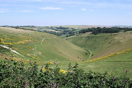
This short Devil's Dyke walk in West Sussex allows you to explore an outstanding feature of the South Downs National Park. The route follows excellent paths and descends into the steep V-shaped dry valley that has become a well-known beauty spot.
The walk starts from the pay and display carpark adjacent to the Devil's Dyke Pub (grid ref. TQ258111) which can be reached by taking a minor road north from the A27 at Westdene (Brighton). After parking it is worth enjoying the excellent view along the northern escarpment of the South Downs. To start the walk head past the pub (on your right) and follow the path on the left-hand verge of Devil's Dyke Road. Ignore the first footpath on the left and continue along the road to reach the South Downs Way. Turn left through the wooden gate and continue along the clear path with the Devil's Dyke on your left.
Ignore all paths on the left and continue ahead. After one kilometre of easy walking, with excellent views to your left, the path forks (grid ref. TQ268111). At this point the South Downs Way forks left and you should continue straight ahead. Continue on this path soon passing a popular viewpoint. The path curves to the left, re-joins the South Downs Way, descends through a car park and joins Saddlescombe Road.
Bear left along the road. On your right is Saddlescombe Farm (National Trust) where it is worth spending some time visiting the large barn with a selection of boards outlining the history of the farm. There is also a large donkey wheel which was used to draw water from a well.
After visiting the farm, return to the road and turn right. After a short distance, turn left through a metal gate by a footpath fingerpost. Once through the gate, follow the clear path which initially bears right and then descend into the valley. Reaching the valley floor, turn left. After 150 metres, turn right over stile and climb the steps up through the wood. Follow the path to a cross path. Climb the six steps opposite, following the path through the woods to a kissing gate.
Go through the gate and climb up the steps. About halfway up there is a superb view through the bushes on the right with the village of Poynings far below. Take your time climbing as there is an excellent view to Fulking village. Continue up this path to a kissing gate above you on your left. Go through the gate and continue back to the car park used at the start of the walk.
Other walks nearby
| Walk 1983 | Edburton Hill from Fulking | easy/mod | 6.1 miles |
| Walk 3487 | Edburton Hill & Devil's Dyke from Saddlescombe | hard | 10.5 miles |
| Walk 3213 | Pyecombe, Devil's Dyke & Upper Beeding | easy/mod | 8.0 miles |
| Walk 2236 | Wolstonbury Hill and Pyecombe from Patcham | moderate | 11.0 miles |
| Walk 2109 | Upper Beeding to Washington by the South Downs Way | easy/mod | 7.0 miles |
| Walk 2903 | Stanmer to Streat | moderate | 12.5 miles |
| Walk 1782 | Steyning Round Hill and No Man's Land | moderate | 7.5 miles |
| Walk 1858 | Cissbury Ring and Chanctonbury Ring | moderate | 10.5 miles |
| Walk 1888 | Cissbury Ring, Chanctonbury Ring & Coombes | moderate | 12.5 miles |
| Walk 2684 | Falmer to Pyecombe & Blackcap by South Downs Way | moderate | 8.8 miles |
Recommended Books & eBooks
Walks in the South Downs National Park
 Guidebook with 40 circular walks throughout the South Downs National Park, exploring the beautiful chalk hills between Eastbourne and Winchester. The walks range from under 5 miles to 11 miles, including Beachy Head and the Seven Sisters, Ditchling Beacon and hundreds of prehistoric sites. Accessible all year, but wild flowers best in spring.
More information
The South Downs Way
 Guidebook to walking the South Downs Way National Trail, a 100 mile (160km) route between Winchester and Eastbourne through the South Downs National Park, described in both directions over 12 stages. Easy walking on ancient and historical tracks, taking in wooded areas, delightful river valleys and pretty villages. With 1:25K OS map booklet.
More information
Messaging & Social Media
Message Walking Britain and follow the latest news.

Mountain Weather
Stay safe on the mountains with detailed weather forecasts - for iOS devices or for Android devices.