Cissbury Ring, Chanctonbury Ring & Coombes
South Downs Walk
Nat Park - South Downs
County/Area - West Sussex
Author - Lou Johnson
Length - 12.5 miles / 20.3 km Ascent - 1200 feet / 364 metres
Time - 7 hours 30 minutes Grade - moderate
Walk Route Description
Click image to see photo description.
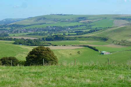
This full day West Sussex walk visits two iron-age hill forts, Cissbury Ring, and the smaller Chanctonbury Ring. The former still retains its impressive ramparts and in addition offers a wide-ranging view along the coast. Topped by a group of beech trees, Chanctonbury Ring also provides extensive views across the South Downs National Park. The lengthy route follows clear paths and tracks with good waymarking.
The start is the small parking area (grid ref. TQ162080) in the west side of Titch Hill, which can be reached from the A27 taking the road signed north past Sompting Parish Church. After parking take the clear track through a metal gate with adjacent fingerpost heading west ignoring tracks going left and right. After two kilometres you reach the small parking area (grid ref. TQ139085) at the foot of Cissbury Ring (National Trust). Turn left and follow the signed path up to the trig point. It is worth making a full circuit of the ramparts before returning downhill to the small parking area.
Reaching the foot of the hill, continue straight ahead keeping the parking area on your left. You now have a steady climb of under three kilometres, ignoring all tracks to the left and right, to reach the main ridge of the South Downs and the South Downs Way (grid ref. TQ145113). Turn left along the SDW and continue up to Chanctonbury Ring and enjoy the view. Retrace your steps along the SDW and continue ahead where you joined it from Cissbury Ring staying on the SDW.
After 1.5 kilometres of downhill walk, you join Bostal Road where you continue ahead following the SDW fingerpost. Use the path along the left-hand grass verge to enjoy the view into Steyning Bowl on the left. Ignore the Monarch's Way on the left and continue for 500 metres to a SDW fingerpost pointing left (grid ref. TQ065090). (At this point you have the option of reducing the length of the walk by 4 miles/6.5 kilometres - see final paragraph.)
To continue the route, stay on the SDW and descend steadily over Annington Hill. Nearing the foot of the descent keep a fence on your right with a pig farm beyond. Follow the track around to the left, bear right leaving the SDW down a steep slope (grid ref. TQ186094) and through a gate to enter a field. Keep to the right-hand side of the field along a bridleway to reach Coombes Road (grid ref. TQ192088).
Turn right into Coombes. After 500 metres turn right (grid ref TQ192083) soon passing a telephone box on the right. Continue up to farm and bear left through a gate following the fingerpost and then right to pass the church on your right. Enter a copse. Exiting the copse, turn right, pass through a gate, and then turn left following a bridleway along the left-hand side of a field. Continue up to pass Coombehead Wood on your right. Continue ahead with a fence on your left a group of trees which will be passed on your left. Reaching a cross track continue ahead and follow the clear track back to the start.
To reduce the length of the walk, ignore the SDW fingerpost pointing left (grid ref. TQ065090) to reach a small parking area. Fork left off the road to join a grassy bridleway that runs parallel to a fence on your left. After just under a kilometre, you reach a cross-track (grid ref. TQ168080). Turn left and follow the clear track back to the start.
Maps 

| Ordnance Survey Explorer OL10 | Sheet Map | 1:25k | BUY |
| Anquet OS Explorer OL10 | Digital Map | 1:25k | BUY |
| Ordnance Survey Explorer OL11 | Sheet Map | 1:25k | BUY |
| Anquet OS Explorer OL11 | Digital Map | 1:25k | BUY |
| Ordnance Survey Digital Map Subscription | |||
| Latest Ordnance Survey Discounts | |||
Other walks nearby
| Walk 1782 | Steyning Round Hill and No Man's Land | moderate | 7.5 miles |
| Walk 1858 | Cissbury Ring and Chanctonbury Ring | moderate | 10.5 miles |
| Walk 2109 | Upper Beeding to Washington by the South Downs Way | easy/mod | 7.0 miles |
| Walk 3078 | Cissbury Ring & Chanctonbury Ring from Washington | easy/mod | 8.3 miles |
| Walk 3310 | Washington to Littleton Farm by the South Downs Way | moderate | 13.0 miles |
| Walk 1983 | Edburton Hill from Fulking | easy/mod | 6.1 miles |
| Walk 3488 | Devil's Dyke Circular | easy | 2.5 miles |
| Walk 1667 | Blackpatch Hill & Harrow Hill from near Storrington | easy/mod | 7.2 miles |
| Walk 3464 | Rackham Hill & Kithurst Hill Circular | easy/mod | 6.7 miles |
| Walk 3487 | Edburton Hill & Devil's Dyke from Saddlescombe | hard | 10.5 miles |
Recommended Books & eBooks
The South Downs Way
 Guidebook to walking the South Downs Way National Trail, a 100 mile (160km) route between Winchester and Eastbourne through the South Downs National Park, described in both directions over 12 stages. Easy walking on ancient and historical tracks, taking in wooded areas, delightful river valleys and pretty villages. With 1:25K OS map booklet.
More information
Walks in the South Downs National Park
 Guidebook with 40 circular walks throughout the South Downs National Park, exploring the beautiful chalk hills between Eastbourne and Winchester. The walks range from under 5 miles to 11 miles, including Beachy Head and the Seven Sisters, Ditchling Beacon and hundreds of prehistoric sites. Accessible all year, but wild flowers best in spring.
More information
