The Silver Walk & Castle Tioram, Loch Moidart
Highland Walk
County/Area - Highland - Fort William Lochaber
Author - Tony Maries
Length - 9.5 miles / 15.4 km Ascent - 2200 feet / 667 metres
Time - 7 hours 0 minutes Grade - moderate
Walk Route Description
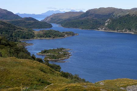
Click image to visit gallery of 8 images.
The Silver Walk is a low-level walk along the south side of Loch Moidart, from Ardmolich Wood on the A861 from Salen to Lochailort, to Castle Tioram where the loch meets the mouth of the River Shiel. There is parking for a few cars at the start of the walk (grid ref. NM715714).
The idea for this walk came during a dismally dreich West Highland morning. As the rain pattered heavily on the windscreen of my car and the hours ticked by, I read Seven Years in Tibet by Heinrich Harrer, and steadily reduced my expectations of what sort of walk I might manage that day. Long past midday the rain became intermittent and eventually I put my boots on and squelched off. I have to confess to a little digital doctoring of some of the pictures, and the ground did not dry as quickly as the skies cleared.
The path was built as an engineered estate path in the late nineteenth century and is named after the discovery of a cache of Elizabethan coinage during construction. There has been a considerable amount of recent work on the path with drainage works, gravelled surfaces and even steps in places. However it hasn't been completely tamed. It is boggy and muddy in places, and there are also large boulders and fallen trees which have to be climbed over. Part of the path follows the loch shore, and it is possible that it may be covered at high spring tide. Castle Tioram is also cut off at high tide. Highlands and Islands Enterprises and the Forestry Commission deserve credit for their work on this path.
From the car park, walk north-west down the path through dense and rather gloomy pine woods in the Glac Mhor (glac=hollow). The dark plantation pines are soon left behind for more attractive natural woodland. After about 1 km (grid ref. NM708717) the path divides. Follow the left fork, which winds through fine natural oak and birch woodland, crosses the Allt Teang Emilstoin, and then climbs up to a fine vantage point above the woods, with views of the full length of the loch, and Skye in the background. The industrious footpath restorers have even provided a bench to sit on.
Retrace your steps back to where the path crosses the Allt Teang Emilstoin. Follow the path which leads down the burn until it comes out at the lower path near to the shore of the loch. Bear west and follow the path as it winds right down to the shore and crosses the Allt an Fheith Dhuinn (this section of the path is not marked on the 2007 edition of the OS Explorer map).
The path climbs through woodlands on the north side of the Meall an Aoil, then drops down to the mouth of the Allt a'Mhuilinn. A ruined house by the burn is a visible reminder of the Highland Clearances. The inhabitants of the townships of Blain, Briag (Briagh) and Portavate (Port a'Bhata) were all evicted by Alexander MacDonald in 1845 and the whole area turned into a large sheepwalk. Sheep proved no more capable of financing the lavish metropolitan lifestyle aspired to by MacDonald than the scattered croft communities he destroyed and the MacDonalds have long since relinquished ownership of the land. Bracken has now reclaimed large areas of former sheep pasture.
Continue north-west along the shore of the loch. The path soon climbs up hill to pass through a low bealach between the north end of Beinn Bhreac and Torr Port a'Bhata. Just over 1 km from the Allt a'Mhuilinn the path forks (grid ref. NM679724). Follow the left fork uphill along the edge of the woods. The considerable number of ruined cottages bears testament to the population which once lived here. Continue south towards Lochan na Fola. Here walk round to the west end of the loch, and walk westward towards the Bealach Sgairt Dea-Uisge. The small lochan in the bealach is dammed and a pipeline leads down hill to supply a fish farm, now disused. Cross a small field and bear right at the road. Continue towards the end of the road at Castle Tioram.
For the first part of the walk along the road there are fine views of the River Shiel. The Shiel is a mere few miles long, connecting the end of Loch Shiel to Loch Moidart. It is remarkable for its' swift current and deep water, and renowned for salmon and sea trout fishing. Ceilidh dance band legend Fergie MacDonald, who lives locally, composed the tune the Dark Waters of the Shiel in tribute.
Castle Tioram is located on a small island, connected to the mainland by a spit of sand which can be walked across at low tide. It is thought to date from the thirteenth century and occupies a strategic commanding position at the mouths of the River Shiel and Loch Moidart. The MacDonalds of Clanranald were confirmed in ownership of the castle in 1373 by King Robert II of Scotland. According to local tradition, Allan, the 14th chief, had forebodings of his demise and ordered the castle to be burned before he left with his men for the battle of Sheriffmuir in the Jacobite rising of 1715.
From the castle, walk back across the sand and head for the shore by the woods. Go through an iron gate and walk along the narrow path around the Sgriobaid Dubh and eastward along the densely wooded south shore of Loch Moidart.
The people of Moidart were predominantly Roman Catholic, and after the failed uprisings of 1715 and 1745 the Catholic Church was savagely suppressed. The priest is supposed to have hidden from the government authorities in a cave somewhere in the dense woodland between Dorlin and Port a'Bhata. His hidey hole in the woods escaped detection, in fact the precise location remains undiscovered to the present day.
The woods are predominantly oak and birch, with the occasional holly, also rowan higher up. The oaks are Sessile Oaks. The poor acid soils result in a far smaller and slower growing tree than the familiar lowland Pedunculate Oak, rarely reaching more than 50 feet in height.
Just before Torr Port a'Bhata you rejoin the outward route, which you can follow back to the starting point at Ardmolich.
Maps 

| Ordnance Survey Explorer 390 | Sheet Map | 1:25k | BUY |
| Anquet OS Explorer 390 | Digital Map | 1:25k | BUY |
| Ordnance Survey Digital Map Subscription | |||
| Latest Ordnance Survey Discounts | |||
Other walks nearby
| Walk 3408 | Beinn Resipol | moderate | 7.0 miles |
| Walk 1161 | Beinn Resipol | hard | 9.0 miles |
| Walk 1813 | Sgurr Dhomhnuill | mod/hard | 8.0 miles |
| Walk 1735 | Monadh Beag and Meall a' Phubuill | hard | 16.5 miles |
| Walk 2597 | Cnoc an Sroine from Selen | easy/mod | 6.0 miles |
| Walk 1163 | Fraoch Bheinn | moderate | 5.0 miles |
| Walk 3270 | Ben Nevis | mod/hard | 9.7 miles |
| Walk 2105 | Ben Nevis via Carn Mor Dearg arete | hard | 10.5 miles |
| Walk 1338 | Ben Nevis Tourist Path | mod/hard | 8.7 miles |
| Walk 1162 | Pap of Glencoe | moderate | 4.2 miles |
Recommended Books & eBooks
Skye's Cuillin Ridge Traverse
 This 2-volume set provides all the information required to complete the main ridge traverse on Skye's Black Cuillin. Strategy, gear, training, navigation and logistics are covered, and 10 classic scrambles are described. A lightweight second guidebook gives the scrambler detailed maps, topos and route description for the ridge traverse itself.
More information
Great Mountain Days in Scotland
 Inspirational guidebook to 50 challenging routes for mountaineers, scramblers, hillwalkers and fell runners, many long enough to backpack over 2 days, especially in winter (12 to 25 miles). A mix of classic routes and unsung gems across Scotland from Galloway to the Outer Hebrides in widely differing wild landscapes. With customised OS mapping.
More information
