River Dee from Farndon
Cheshire Walk
County/Area - Cheshire
Author - Lou Johnson
Length - 4.0 miles / 6.5 km Ascent - 150 feet / 45 metres
Time - 2 hours 10 minutes Grade - easy
Walk Route Description
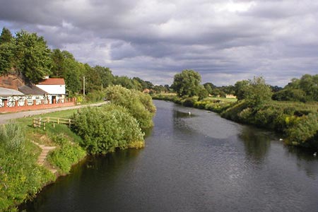
Click image to see photo description.
This short Cheshire walk starts from the village of Farndon which lies on the east bank of the River Dee. The River Dee forms the boundary between England and Wales and by this stage the river meanders across the flood plain.
The start is the free car park which lies behind the Parish Memorial Hall in the centre of the village (grid ref. SJ413545). Exit the car park and turn right along Church Lane. Continue along the lane with the churchyard on your right. Reaching a junction, go straight ahead down a tarmac path (signed no vehicles). This leads you to the High Street. Turn left and continue down to the river Dee. (An interesting diversion from the main route is to turn left following the riverbank for about half a mile to the remains of Holt Castle, which are across the river. If you take this option return along the path to bridge.)
The main route takes the signed footpath on the right just before crossing the river bridge. Follow this path keeping the River Dee on your left. The path follows the meandering course of the river for just under one and a half miles to reach Willows Fish Farm (grid ref. SJ399566). Follow the path past the Fish Farm to reach Townfield Lane. Go straight across to regain the riverside path to enter woodland. After 400 metres of woodland walking you reach a path junction (grid ref. SJ405563).
Turn right here, leaving the riverside path, soon exiting the woods. Join an enclosed track (Knowl Lane). After 350 metres turn right at a signpost (grid ref. SJ411564). Follow the track along the left-hand side of the field (with the field boundary to your left). The track bends right and then left to reach some barns (grid ref. SJ413561). Turn right between the barns and follow the track to a T-junction. Turn left and follow track south for 200 metres to a junction of tracks (grid ref. SJ411559).
Go ahead to join an enclosed track heading south. Follow this path/track south for about one kilometre to reach a road (grid ref. SJ413548). Continue ahead down the road which will lead you back to the centre of Farndon village.
Maps 

| Ordnance Survey Explorer 257 | Sheet Map | 1:25k | BUY |
| Anquet OS Explorer 257 | Digital Map | 1:25k | BUY |
| Ordnance Survey Digital Map Subscription | |||
| Latest Ordnance Survey Discounts | |||
Other walks nearby
| Walk 2460 | Pontcysyllte Aqueduct Circular | easy | 4.5 miles |
| Walk 2598 | Ruabon Mountain, World's End & Panorama Circular | moderate | 12.5 miles |
| Walk 2905 | The Llangollen Canal from Ellesmere | easy/mod | 8.0 miles |
| Walk 2388 | Chirk Castle & Ceiriog Valley | easy/mod | 6.0 miles |
| Walk 1067 | Ruabon Mountain & The Limestone Edges of Llangollen | moderate | 11.0 miles |
| Walk 1259 | Foel Fenli & Moel Famau from Loggerheads | moderate | 9.5 miles |
| Walk 1845 | Castell Dinas Bran from Llangollen | easy/mod | 4.0 miles |
| Walk 2578 | Cheshire Lanes and Woodhouse Hill Fort | easy/mod | 7.0 miles |
| Walk 3655 | Rhewl, Moel y Gamelin & Moel Morfydd | moderate | 5.4 miles |
| Walk 1528 | Moel Famau | easy/mod | 10.0 miles |
